Dams/Barrages Relation to Recent Arsenic Poisoning
1. INTRODUCTION 2. GROUNDWATER CONTAMINATION BY AGRICULTUR 3. Arsenic problem in Bangladesh acute due to upstream dam 4. CONCLUSION
Kailidas, the greatest poet of Indian sub-continent, centuries ago in his poem "Raghu Dynasty" praised the majestic beauty of the meeting place of the Ganges and the Jamuna rivers but now it has become the garbage of the nation. The increase rate of contamination is intensively jeopardising the future of this sub-continent.The Brahmaputra-Gangetic plain stretches from the Himalayan foothills in the north down to the Bay of Bengal in the south, a distance of 555 kilometres. The three major rivers , namely the Padma (Ganges), which enters the country from the west, the Jamuna (Brahmaputra) enters from the north, and the Meghna which enters from the north-east form a great deltaic complex known as the Ganges delta (Fig.: 3). The prominent feature of this plain is the network of rivers streams (Khal), lakes (Bils), swamps and marshes.The Ganges-Brahmaputra-Meghna delta is the largest delta in the world. The Himalayan rivers contribute one-third of the global sediment transport to the world oceans (Millman et al., 1983). Since millions of years the Bengal basin received millions of flood that created this land to the present form.
With the birth of the modern Himalayan Mountains about 35 million years ago the mighty rivers drained along paleoslopes and deposited about 16-18 kilometres of thick sediments in Bangladesh. The ancient river records of this region show several overflows of the channels during the period of high discharge. Sediments of the confluent Ganges-Brahmaputra-Meghna rivers are today deposited predominantly in the huge subaerial delta of these rivers, but during lowered sea levels of the geological past they poured largely into largely in the submarine canyon in the east (Figs. 1 and 2). The shifting of submarine canyons and deeps fans from east to west since 75 million years is one of the remarkable features.
The rivers deposited sediments as active river flood plains, braided flood plains, meander flood plains, major flood plain basins, estuarine flood plains, tidal flood plains and deep sea fans. The Ganges-Brahmaputra river system, the second largest river system of the world, anticipates special significance.
This delta is divided into two parts. The western part is composed of almost flat very swampy plain with large number of rivers, channels and lakes. The eastern part is detected by the presence of different large and small islands divided by large water bodies. The western part of this delta is now dead. There is absolutely no drainage from the either the Ganges or Brahmaputra rivers. The only water supplied is by tides only.
The eastern part of the Meghna river delta is very active, where various tributaries like the Tetulia, shabazpur etc. carry as much as 2.3 million cusses of water during high tide. The external edge of the delta is made up of marine origin relief. This represented by gentle low abrasional scarps about 3.2-4.9 feet (1-1.5 meters) high of finely scalloped contours. The offshore bars unlike the deltaic clayey sediments consist of multi grained sands with typical marine fauna.
Channel migration of two major rivers of the world - the Ganges and the Brahmaputra and numerous tributaries attributed a very complex geomorphic pattern. Other major rivers seek steeper gradient to sea whereas the following factors are suggested for river migration in Bangladesh:
- Recent tectonic movements;
- Flood caused by tropical monsoon;
- Heavy sediment-load (natural);
- Heavy sediment-load (man made);
- Modification by man (dam, channel etc.).
A research study at Free University Berlin, Germany confirms that during the dry periods, in the rivers south-west of Bangladesh low surface water level favours intrusion of surface water salinity from the Bay of Bengal higher than previous records (Hassan, 1992). The estuarine ecosystems (physical, chemical and biological) are interrupted due to non availability of fresh water during the dry season (November-May). About 38 per cent of the country's territory and 33 per cent of the population is already affected by salinity in the water supply. Water supplies for rural and urban users have become saline. Numerous jute mills, a newsprint mill and a power station in Khulna district have to bring in fresh water in barges from areas 100 km. upstream to maintain uninterrupted operations. The Bhairab River used to have a salt content of 1,950 ppm in April 1987, whereas in 1988 it increased to 5,250 ppm.
Besides, during the dry season there is a rapid increase in vector-borne diseases which account for thousands of deaths in Bangladesh. FAP (Flood Action Plan, 1992) reports that after the construction of high embankments the changed drainage conditions in the north-west region are likely to display negatively (Fig. 7). Barriers to drainage by these structures would in result stagnation of waters. Already the poorest are suffering from malnutrition, and with the loss in catches of fish will result in more malnutrition and make people highly susceptible to diseases. WHO (1990) reviewed the negative effects on health of water resource development in 13 countries (including some from Africa, Asia, and Latin America) and in all there were indications that projects to develop water resources had resulted in higher incidence of vector-borne diseases. Different types of irrigation systems (surface, subsurface, over-surface, continuous flow, and intermittent flow) and different water distribution cycles have different effects on the transmission of vector-borne diseases. According to WHO (1992) the irrigation schemes that appear to present the greatest risk of increased transmission of vector-borne diseases are those located where:
- soils present drainage problem
- rice is cultivated
- reservoirs are constructed
- canals are unlined
- there is compacted settlement or
- resettlement.
In 1964 Government hired foreign consultants to chart 20 year Master Plan for water resources development. 58 Master Plan Projects at a cost of 2 billion US Dollars were carried out to built thousands of kilometres of embankment to boost agricultural production. Farmers advise was not taken to consideration. Between 1959 and 1993, 482 small, medium and large projects were implemented. The total cost of all these projects exceeded 5 billion US Dollars. The lion share of this money came as loans or grants from donor countries and agencies (Hossain, 1994). At no stage were local people consulted about the design or implementation of any of the schemes. Kumar River Project is one of the most devastating structures that stopped sustainable agriculture and harmonious society.
). In the planning projects farmers' requirements and knowledge are not considered . Mainly engineers' decisions and designs are imposed on them. For example, under the Ganges-Kobadak Irrigation Project construction of flood embankments turned flowing rivers like Kumar, Kaliganga and Dakua into dead rivers which created serious ecological disaster. Another example of ecological disaster is Horai River Sub-Project where in February 1989 in inlet of the Horai River at the Padma(Ganges) end closed down which resulted in drying up of 20 beels(wetlands) of 9,000 acres. Exploitation of aquatic vegetation and fruits like makna, singra, lotus, lily, hogla on a large area under thin aquatic vegetation. This has also contributed to the decline of fish and migratory birds (Nishat,1993).
But in fact, production gains on land behind embankments tended to be short lived. The intensive cropping and excessive use of agrochemicals promoted by the Green Revolution soon began to take their toll, as farmers abandoned traditional methods of soil fertility (flooding irrigation), rotating crop varieties etc. In the mean time, companies such as Ciba-Geigy are doing roaring trade in Bangladesh.
The excessive use of chemical fertilisers (ammonia, nitrates and phosphates) to cultivate HYV rice, indeed, decreases the take-up of natural nutrients, diminishes the ability to hold water and accelerates erosion. The high deposition of ammonium results in an accumulation of ammonium in soil and in a simultaneous leaching of essential nutrients as potassium, calcium and magnesium from the soil and also leads to damage the root system. The rate of higher productivity of HYV varieties is based on the capacity of photosynthesis and the maximum capacity has arrived. The government and many organisations in Bangladesh have reported that the deterioration in soil fertility is attributed to continuous mono-cropping of rice, particularly HYV rice.
Prof Shajahan of BUET (1994) says , "Such flood control and irrigation projects tend to focus exclusively engineering aspects, neglecting the people, water soil, fish, vegetation - many vital concerns." The high water technology of the West seems poorly suited to both peoples and the lands of developing countries where, as we have seen, the issues surrounding water are more complex and different in kind to those of the temperate regions.
2. GROUNDWATER CONTAMINATION BY AGRICULTUR
Pesticides, fertilizers, herbicides and animal waste are agricultural sources of ground water contamination. The means of agricultural contamination are varied and numerous, but some examples as follows:
Spillage of fertilizers and pesticides during handling; Runoff from the loading and washing of pesticide sprayers or other application equipment; Using chemicals uphill from or within a few hundred feet of a well. Agricultural land that lacks sufficient drainage is considered by many farmers to be lost income land. So they may install drain tiles or drainage wells to make the land more productive. The drainage well then serves as a direct conduit to ground water for agricultural wastes which are washed down with the runoff. Storage of agricultural chemicals near conduits to ground water, such as open and abandoned wells, sink holes, or surface depressions where ponded water is likely to accumulate. Contamination may also occur when chemicals are stored in uncovered areas, unprotected from wind and rain, or are stored in locations where the ground water flows from the direction of the chemical storage to the well. According to the Ministry of Environment and Forest (1991), Government of Bangladesh, since the last decade average HYVs and irrigated rice yield have been dropping. Year round transplanted rice cultivation keeps the land waterlogged continuously for many years. This, in turn, leads to the formation of toxic compounds in soil, loss of essential nutrients like zinc and sulphur through deep percolation, and the spread of soil-borne diseases which thrive in this water-logged, and which become difficult to eradicate.
WHEN DID THE GROUNDWATER ARSENIC POISONING IN BANGLADESH BEGIN?
Thomas E Bridge Professor of Geology (Emeritus), Emporia State University, Kansas, USA and Meer T. Husain (2000) reports:
The UK/DFID statement on the age of the arsenic poisoning in groundwater in Bangladesh contradicts the historical medical evidences. In 1999, Miah, M. A., University of Arkansas, U.S.A. reported that prior to the 1970's hundreds of thousands of people in 2800 villages of Ganges Delta drink water from 280,000 hand-dug wells. The wells were about one to two meters in diameter and about eight meters deep. We know of no difference in the inorganic and organic quality of water from tubewells and hand-dug wells. Both extract water from subsurface geological formations i.e., groundwater and from about the same depth.
If groundwater arsenic contamination had been present for thousands of years, as suggested by the UK report, then both shallow hand-dug wells and tubewells would extract arsenic contaminated water and would have impacted water users with arsenic poisoning before 1975. If the UK/DFID statement were true, then prior to 1965 the people who had been drinking hand-dug well water for hundreds of years would have certainly been poisoned by arsenic. Prior to 1975 there is no evidence that arsenic poisoning had affected people
in Bangladesh, therefore, it appears that the groundwater arsenic poisoning in Bangladesh is a recent environmental episode and began after 1975.
During the 1965 to 1975 period about 4.5 million wells were installed and millions of children and infants drank water from these wells. Therefore, the UK/DFID statement on the age of groundwater arsenic poisoning in Bangladesh is not based on scientific facts but rather it is based on speculation.
The mineral pyrite occurs in several different morphological forms and the grain sizes ranging from invisible to several inches in size. The "framboidal" form is considered highly reactive and characterized by a small grain size and large surface area. Frequent lithofacies change, vertical and horizontal distribution of thickness are common in a delta. Water table elevations in the Bengal delta fluctuate in response to seasonal conditions forming a zone of cyclic wetting and drying. This provides optimal conditions for the oxidation and subsequent leaching of pyrite and associated weathering products. Bangladesh has been experiencing an abnormal cyclic wetting and drying for the last 23 years which allows enough time for oxidation of pyrite minerals. The sulfate concentration level in water depends on many factors
- Pyrite grain size.
- Length of time (23 years) of cyclic wetting, drying, and leaching.
- Pyrite abundance, reaction rate, migration time from generating area to the sample collection location,.
- Residence time, dilution factor due to precipitation, water table fluctuations and addition or loses from other sources.
OFFSITE SOURCES OF ARSENIC CONTAMINATION IN BANGLADESH
Bangladesh is located down gradient from West Bengal. During wet season the country receives huge amounts of surface water and pollution carried by rain water from the Indian Subcontinent. The groundwater flow directions of major aquifers in the six districts of West Bengal are to the south and south easterly direction towards Bangladesh. Being located down gradient, Bangladesh is receiving huge quantities of arsenic contaminated water from West Bengal. The migration of arsenic contaminated water from West Bengal to the Ganges delta of Bangladesh may have increased the concentration of arsenic in both soil and groundwater
A contributing factor to the groundwater arsenic poisoning in Bangladesh may have been India's 23 years of unilateral diversion of water from the Ganges river. In 1995, Miah, M.A. in the article "Farakka the Death Trap" states that" India's continued diversion of 1,133 cum/sec out of 1728 cubic meter per second for about two decades during the dry season, has made serious impacts on the Ganges basin ecosystems. He further states"water level in ponds have dropped about 60 percent both in quantity and duration. During dry seasons agriculture has had to rely on underground water for irrigation". In 1996, Miah M.A. in the article The Water Crisis in Bangladesh A challenge to Integrated Water Management in Urban Areas states that "Farakka is not only the name of the barrage on the Ganges, it has been a symbol of environmental havoc in the national life of Bangladesh.
"Farakka is not only the name of the barrage on the Ganges, it has been a symbol of environmental havoc in the national life of Bangladesh. India has built barrages on 17 more rivers in the east and northeast border with Bangladesh. The Barak barrage to the northeast corner near 25 degree parallel is one of them. The construction of this barrage is built at Teepaimuch which is located between Assam and Manipur provinces. The barrage will be built at a height of 161 meters. The Farakka case study gives us enough information on what we can expect from the rest of the barrages. The Barak barrage will affect the east and northeast part of Bangladesh which fall under the Meghna basin"
In addition to the Farakka barrage, the 17 dam/barrages that India has constructed may have significant influence on the arsenic and other environmental disasters in Bangladesh.
There is a strong correlation between the post Farakka disasters and the Farakka barrage . The hydrograph shows the annual Pre Farakka discharge (1968-1974), the discharge under natural condition and the annual Post-Farakka discharge (1975-1996), the discharge because of India's unilateral diversion violating the natural as well as international river laws has caused many disasters both down stream and up stream. The construction and commission of Farakka barrage, India's 23 years of unilateral diversion of water, the construction of other dams/barrages in common rivers of Bangladesh and India the following disasters in Bangladesh are believed to have been caused by or aggravated by these projects.
WASHINGTON, Nov 30: More than 50 per cent of the world's major rivers are seriously depleted and polluted, poisoning surrounding ecosystems and threatening the health of tens of millions of people, says the World Commission on Water (WCW). A similar problem affects the Ganges, which serves 500 million people. It has become so depleted that during the dry season, the Sundarban wetlands in Bangladesh-one of the world's most unique ecosystems comes under serious threat. In Eurasia, the sickest rivers labeled "very unhealthy" by the commission-include in Central Asia, the Gages, which flows from the Himalayas to the Bay of Bengal.
The groundwater arsenic poisoning in Bangladesh is a recent environmental episode. It appears to be directly related to the Farakka, Tista and other dams/barrages that India constructed in the Bangladesh and India's common rivers. The arsenic contamination in Bangladesh began after 1975.
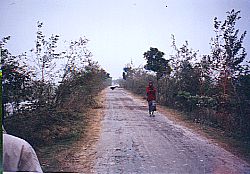
Picture1: Flood water protected area: Arsenic contaminated area. Pictiure middle: Embankment. Picture right:; Flood water from Padma enters here. No arsenic contamination.
This a sad story how green revolution destroyed the very existence of poor farmers live inside the embankment to protect IRRI rice that can not stand flood water. Under the project engineers connstructed embankment (middle picture) to inhibit entry of flood water without consulting the farmers. Farmers about one million population live along Kumar river do not obtain any flood laden soils that existed thousands of years. Now except IRRI rice nothing grows. More and more chmical fertilizers and pesticides are added every year. The land (right in picture) grows three times the crop than inside embankment. No arsenic contamination here.
The land price is also three times higher. Shukir Miah said, "You see, we are now ruined. Without flood water we cannot cultivate any more, we could plant lentils, mustard several other varieties of rice before!".
Farmers tried to break the embankment. But police and soldier protected the embankment.
3. Arsenic problem in Bangladesh acute due to upstream dam
International expert on Arsenic, Water and Environment Meer Husain said the Arsenic problem in Bangladesh has become acute due to man-made dams in the Trans-border Rivers like the Farakka and Tista Barrages that impede the natural river flow. Husain, who is also a Geologist in a US college, said the natural river flows have to be resumed by removing the river-dams to solve the arsenic problem, he said. He stressed on the coordination with India to solve the problem. Meer Husain was addressing a seminar styled "World's largest Man-Made Arsenic Disaster in Bangladesh and Sustainable Solution to the Problem" organised by the Geology Department of Dhaka University (DU) at its auditorium.
DU Pro Vice-Chancellor Prof Dr AFM Yusuf Haider also addressed the seminar, which was presided over by Chairman of the Department Prof Dr Kamrul Hasan. The Pro-VC urged the scientists to work more for a sustainable solution of arsenic problem, as the problem has become alarming in Bangladesh.
He said Bangladesh is a disaster-hit country. Natural disasters and man-made disasters hit the country frequently. Arsenic is one of the man-made disasters, he added. He further said most of the country's crops and industrial production depend on the underground water, but approximately 10 million tube-wells are affected by arsenic across the country.He also said more than 30 million people of the country are drinking the arsenic contaminated water. He urged the scientists to conduct researches to develop the solution of arsenic problem with a view to save the people from the curse of arsenic (The New Nation, July 01, 2008 ).
The natural groundwater flow that existed prior to 1975 should be restored by removing all dams/barrages that India constructed in the common rivers of Bangladesh and India. The removal of dams/barrage and the dredging of rivers will decrease the number of disasters in both Bangladesh and in the upstream region of India. And most importantly stopping the use of contaminated agrochemical and introduce traditional agriculture.
Last Modified: July 1, 2008