The Ganges Barrage: Ecological Disaster
Before partition (1947) of India, water was not withdrawn from upstream side of the Ganges river and its tributaries. Kolkata Goalonodo railroad restricted entrance of Ganges water into its right branches in the last part of the 19th century. In consequence quantity of water in the flow of main stream of the Ganges gradually increased in the first half of the 20th century and the Ganges itself had to carry more than 90 per cent of its total discharge.
At that time the Padma river at Goalondo was enough deep and wide and the British railway authority had to protect right bank of the Ganges (the Padma) at Goalondo by revetment works. Then large vessels (steamers) plied between Goalondo and other river ports of the country. At that time road communication did not develop. Railways and steamers were the only media for communication. Then rivers and canals all over the country were sufficiently deep and wide. Trade and commerce were chiefly dependent upon river communication.
The Brahmaputra river meets the Ganges at Goalondo. Normally accumulated monsoon discharge of the Ganges and the Brahmaputra remains below 1,40,000 cubic metres per second. Before partition of India, configuration of the Ganges at Goalondo was capable of discharging that quantity of water very smoothly. Retention of Ganges water by India has reduced quantity of water in lean (dry season) flow of the Padma. As a result, a part of the Padma, from Goalondo to Daulatdia, accreted in the decade of the last sixties. Goalondo became land-locked and communication system via Goalondo was disrupted totally. Bangladesh felt necessity of restoring the communication system and connected Daulatdia by highway in 1975. Railroad was extended to Daulatdia in 1985.
Cross border rivers, which approach Khulna Division of Bangladesh from western border, do not carry upstream water as India restrains their lean flows. Eventually, bed level of all the branches of the Ganges from Kushtia border to Goalondo have been choked up. Now, these rivers (the Mathabhanga, the Gorai, the Chandana, etcetra) do not have flow in dry season. As a result, the rivers flowing over greater Kushtia and greater Jessore districts are almost dead. Many of them are yet found in maps, but all of them do not exist in the field.
Bed level of many of them are not sufficiently high and in many places river beds have been brought under cultivation. As a result, Khulna Division remains bereft of sweet (upstream) water supply in dry season. The prevailing situation has facilitated entrance of saline sea water far deep into all coastal rivers beyond their estuaries. Now, saline water arrives at the lower reach of greater Jessore district. All the coastal rivers, where saline water intrudes, are now being silted up at an alarming rate.
The Sunderbans, the largest mangrove forest of the world,t became poorer and more open as one proceeds towards the sea or towards the west (India). The fresh water zone The fresh water zone in the north is generally most productive with good quality sundri, gewa, passur, kranka and other timber species flourishing. But with the increase of salinity the mangrove ecosystem has been seriously affected after the construction of the Farakka dam in India. The abnormal reduction of the Ganges flows during dry period have caused excessive siltation, elevation of the bed level sand consequent reduction of flood water discharging capacity of the channels, shifting of Ganges flows thereby blockage of the Gorai river off take.Construction of polders and closures (Cross-dam on rivers) in low- lying coastal belt have worsen the situation. Now, most of the rivers in between two polders have ceased to exist. Now, bed levels of many coastal rivers are higher than low-lying beels of upstream sides. As a result, beel Dakatia of Jessore district remains water-logged throughout the whole year. It may be mentioned that continuous dredging has failed to keep drainage routes (downward rivers) of beel Dakatia active.
Besides this, drainage congestion of upstream water in Satkhira district arose catastrophic flood in September 2000. Now, 98 per cent navigation routes of Khulna Division are out of use or defunct and navigation route of Mongla port has been running a risk. Environmental and ecological condition of the Sundarban mangrove forest has been deteriorating continuously in absence of sweet (upstream) water supply.
After commission of Farrakka Barrage, India restrained lean flow of the Ganges unilaterally till water accord of 1996 took effect. Water accord of 1996 was a diplomatic decision. It was arbitrary and whimsical as it evaded and ignored the concepts of hydrology. The accord distributed quantity of Ganges water available in lean flow of the Ganges at Farakka between India and Bangladesh. It did not account for the volume of water which India restrains and withdraws from upstream side of the Granges and its tributaries and failed to value the adverse affect of withdrawal of upstream water on the configuration of the Ganges itself and its branches at down streamside.Practically, quantity of water in lean flow of the Ganges came down to 70,000 cfs or less in the decade of sixty last. It (70,000 cfs or less) was a fraction of the quantity of water, which was present in lean flow of the Ganges before partition of India and was no longer able to keep up its (Gange's) configuration intact, the concerned countries (India and Bangladesh) did not take any initiative to increase quantity of water in lean (dry season) flow of the Ganges at Farakka and distributed the quantity of water now available in the lean flow at Farakka after withdrawal of large volume of water from lean flow of it and it tributaries at their upstream sides.
(D. S. Ahmed, 2003).
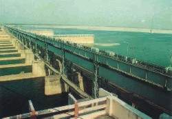
Farakka Barrage gates closed, serious economic,
environ problems in S-W regionKUSHTIA, Jan. 8, 2004:—The water level in the Ganges registered sharp fall and now stands at 6.30 meters at the Hardinge Bridge with a minimum discharge of around 1,420 cusecs of water per second, a source close to the Bangladesh Water Development Board (BWDB) disclosed. The water level is falling around 3 inches per day and as the lean period continues, drastic fall in the water level is feared, the source added.
According to information available across the border, all the gates of the Farakka Barrage have been closed and the Ganges water is being diverted through the link canals to serve irrigation projects in India. The water experts fear that if such situation continues, the mouth of the Gorai, the only source of fresh water supply to the whole of south-western region will be completely blocked in February this year. Last year in March, the mouth of the Gorai was blocked following heavy siltation and there was no water flow in the Gorai. It is feared that this year the Gorai would be blocked completely in February, a reliable source disclosed. This would cause serious economic and environmental problem for the people belonging to the whole of the south-western region, a water resource expert commented.
The Gorai excavation programme by the GRC, an interntional contractor comprising Netherland and Belgium was stopped by the BWDB and there was no dredging in the river for the last two years.
A reliable source close to the BWDB disclosed that the Ganges-Kobadakh project might not be able to supply irrigation water to atleast 1,16,000 hectares of land in four western districts following breakdown of the main pump house consisting of three major pumps and two of the pumps were completely out of order and the rest one had less than 40% capacity and remained out of order on a number of occasions causing disruption in supply of irrigation water (The Daily Observer, January 9, 2004).WASHINGTON, Nov 30: More than 50 per cent of the world's major rivers are seriously depleted and polluted, poisoning surrounding ecosystems and threatening the health of tens of millions of people, says the World Commission on Water (WCW). A similar problem affects the Ganges, which serves 500 million people. It has become so depleted that during the dry season, the Sundarban wetlands in Bangladesh-one of the world's most unique ecosystems comes under serious threat. In Eurasia, the sickest rivers labeled "very unhealthy" by the commission-include in Central Asia, the Gages, which flows from the Himalayas to the Bay of Bengal.
Water availability drops significantly
The overall water availability in the country has dropped significantly. The country faces water scarcity in the dry season due to decline in flow from upstream reaches, encroachment of wetlands and siltation of natural water bodies. The findings came out in the final report on 'Water availability and usage regime in rural Bangladesh' commissioned under sustainable environmental management programme of ministry of environment and forest and UNDP released here yesterday.
The report, prepared by DPHE and IUCN, said people's access to safe drinking water still falls critically short of the World Health Organisation (WHO) standards. There is a serious shortage of irrigation and drinking water in many parts of the country during the dry months from December to March, it pointed out. Moreover, human activities such as use of agro-chemical and dumping of industrial and municipal wastes in the open water bodies have seriously deteriorated the surface water quality, the report said.
The report said that to make things worse, over 60 per cent of the country has shown sign of arsenic contamination in the groundwater. These quantity and quality crises have major economic and ecological impacts on the communities. The number of people competing for the resources is one of the key factors in determining the fresh water availability. The 128 million population is growing at the rate of 1.8 per cent per year. Even if a two-child family norm is achieved today, the population is estimated to reach over 230 million by 2030. Thus access to good quality water will become a critical issue unless the resource is now managed in a sustainable manner, the report said.
Agricultural water requirement adds much pressure on water availability, as this sector alone claims about 85 per cent of all water use. Introduction of irrigation based HYV crops has changed the water dynamics in a major way. Natural hydrological cycle has been altered by flood control, irrigation and drainage projects - the primarily focus of which was to facilitate HYV rice cultivation, the report added.
(BSS, 12. 10. 03)Back to Home Garden
Back to INDIA-BANGLADESH: 21st CENTURY BATTLE FOR WATER SHARING
Top of Page
Home