 |
 |
 |
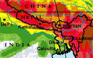
Tragedy in the Himalays and Ganges-Brahmaputra Plain -
Flood, drought, earthquake and cyclone
You Tube: Bangladesh cyclone kills ..
Over 2,200 Die In Bangladesh Cyclone - Bengali Disaster
Bangladesh Cyclone Sidr on MSNBC
Cyclone Sidr Banglades aftermath CBS Nov. 17, 2007
Cyclone Sidr's Deadly Trail Bangladesh Nov. 17 2007
Cyclone Sidr Bangladesh delivering AID Nov. 17, 2007
Cyclone Sidr Ripped Bangladesh
Destruction in storm ravaged Bangladesh - 17 Nov 07 - Barisal
Climate Change
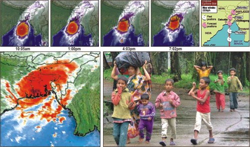
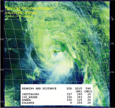
Cyclone Aila - May 25, 2009
 |
 |
 |
 |
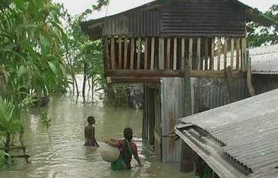
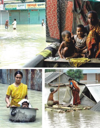
Tropical Storm Aila struck southern Bangladesh and eastern India on May 27, 2009. The New York Times reported that floods and mudslides killed at least 191 people and left hundreds of thousands more homeless. As of May 27, the death toll was expected to rise.
According to the Associated Press, some 2.3 million people were affected by Aila, many of them stranded in flooded villages. Storm surges in Bangladesh flooded agricultural areas with salty water. Home to roughly 25,000 residents, the coastal island Nijhum Dwip was reported to be completely submerged. As of May 27, 2009, many rural villages had not yet been reached by relief workers, and the death toll was expected to rise significantly as search and rescue efforts continued.
"Millions of people have been affected by the cyclone, with half a million in shelters and another half a million forced from their homes or were marooned," a disaster control official told the Reuters news agency in Dhaka, the Bangladeshi capital.
Heavy rain triggered by the storm also raised river levels and burst mud embankments in the Sundarbans delta in West Bengal.
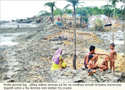
The worst affected area in Bangladesh was the Satkhira district, near the port of Mongla, where a local official said 31 bodies were found in one village.
"The situation here is alarming," Mohammad Abdus Samad, deputy commissioner of Satkhira, told Reuters.
Diarrhoea has broken out in Cyclone Aila-hit coastal areas of Khulna and Satkhira as an acute scarcity of drinking water and food worsened sufferings of thousands. At least two people died of diarrhoea in Khulna coast yesterday, and over 100 were attacked with the disease in coastal areas of the two districts. The situation might turn alarming unless drinking water is immediately made available, reports quoting locals said. Meanwhile, unofficial estimates said death toll from the cyclone rose to 175 yesterday (Daily Star, May 30, 2009).
State of persons with disabilities during disaster10% of the population in Bangladesh are persons with disabilities. They are one of the most vulnerable groups in any kind of situation, especially in the different stages of the disaster cycle.
|
Cyclone Hits Bangladesh, November 16, 2007
At least 425 people were killed and thousands injured in 18 districts as the powerful cyclone Sidr lashed the country's south and south-western regions last night.
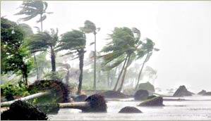
The terrible tropical storm that packed speeds of up to 240 kilometres per hour, made landfall in the Barisal-Khulna belt last night, flattening tens of thousands of houses and uprooting numerous trees.
"The hurricane crossed the coast at 3:00am early today (Friday) and was now lying over the southern and central parts of Bangladesh as a land depression this morning," a latest meteorological office bulletin said.
A total blackout gripped the country after Thursday midnight as all power stations tripped under the impact of the hurricane.
More than 100 people were killed and some 300 went missing in the worst-hit Bagerhat district. Besides, hundreds of people were wounded and thousands of houses flattened in the coastal district, police said.
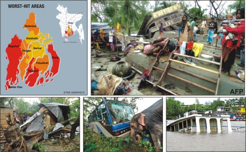 The Daily Star reorts (Nov. 17, 2007):Death toll may cross 1,000; all communications, utility services snapped; thousands missing; houses, crops, trees destroyed; lakhs homeless.
Bangladesh dated with a nightmare as cyclone Sidr ripped through the southwestern coast late Thursday, killing over 700 people and demolishing houses, crops, vegetables and trees alike along its trail of devastation over an area of thousands of square kilometers.
Packing winds over 220km an hour, the fierce tropical storm roared across the shoreline after it hit landfall at the Khulna-Barisal coast at 7:30pm Thursday, cutting off all communications and utility services across the country.
The Daily Star reorts (Nov. 17, 2007):Death toll may cross 1,000; all communications, utility services snapped; thousands missing; houses, crops, trees destroyed; lakhs homeless.
Bangladesh dated with a nightmare as cyclone Sidr ripped through the southwestern coast late Thursday, killing over 700 people and demolishing houses, crops, vegetables and trees alike along its trail of devastation over an area of thousands of square kilometers.
Packing winds over 220km an hour, the fierce tropical storm roared across the shoreline after it hit landfall at the Khulna-Barisal coast at 7:30pm Thursday, cutting off all communications and utility services across the country.
“I've never seen anything like this in my 47 years life,” Khalilur Rahman, a government official in Patuakhali, told The Daily Star over telephone last night. “It was a panic beyond description. People found no way but to keep on screaming as long as the cyclone ran rampage here.”
One of the fiercest cyclones in the history of the land, the Sidr rode
on wailing winds, driving rains and tidal surges to wreak havoc for over 14 hours before moving to Asam and Tripura through the Sylhet border, turning into a well-marked low yesterday (Nov. 16, 2007).
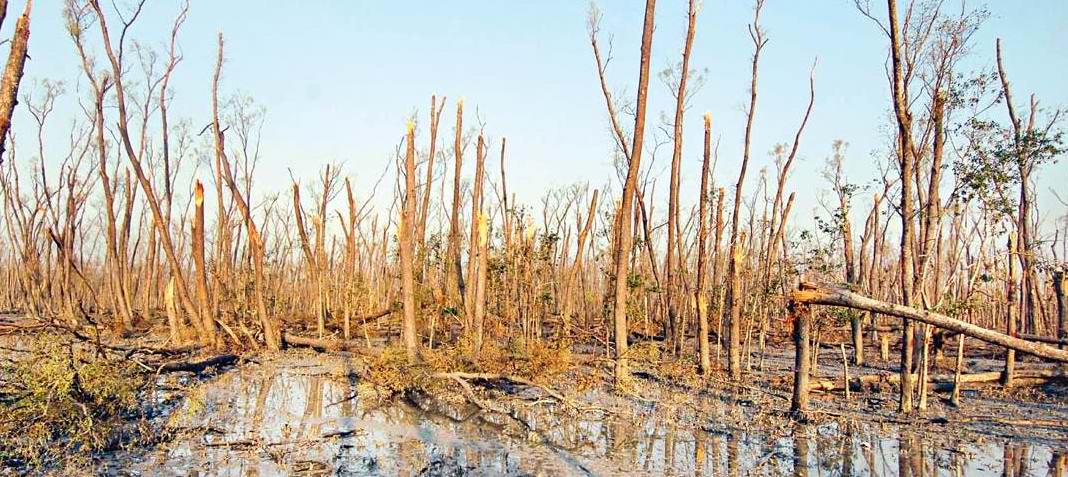
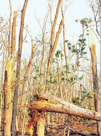 Environmentalists and bio-diversity experts fear immense loss to the Sundarbans and its wildlife, as the brunt of hurricane Sidr was borne by the world's largest mangrove forest.
Sidr, with a ferocious wind force of over 220 kilometres per hour (kmph), hit the eastern parts of the forest, especially Chandpai range including Kochikhali, Kotka, Hiron Point, and Dublarchar, leaving a trail of severe devastation. The uprooted trees and destroyed houses on the edge of the forest are reminiscent of the devastation brought to the forest by the cyclone of 1988, sources said.
Environmentalists and bio-diversity experts fear immense loss to the Sundarbans and its wildlife, as the brunt of hurricane Sidr was borne by the world's largest mangrove forest.
Sidr, with a ferocious wind force of over 220 kilometres per hour (kmph), hit the eastern parts of the forest, especially Chandpai range including Kochikhali, Kotka, Hiron Point, and Dublarchar, leaving a trail of severe devastation. The uprooted trees and destroyed houses on the edge of the forest are reminiscent of the devastation brought to the forest by the cyclone of 1988, sources said.
 Ruining the beautiful, green landscape, cyclone Sidr has dealt a severe blow to the Sundarbans, destroying 1,528 square kilometres of the forest out of around 6,000 square kilometres, according to forest officials' primary assessment.
Of the devastated areas totalling about one-fourth of the forest, 1,200 square kilometres are land and the rest water bodies.
Ruining the beautiful, green landscape, cyclone Sidr has dealt a severe blow to the Sundarbans, destroying 1,528 square kilometres of the forest out of around 6,000 square kilometres, according to forest officials' primary assessment.
Of the devastated areas totalling about one-fourth of the forest, 1,200 square kilometres are land and the rest water bodies.
The officials assess that more than Tk 1,000 crore worth of forest resources have been lost in addition to another Tk 20 crore in infrastructure damage.
Though a chunk of the forest has been completely destroyed carcasses of only one tiger, 38 deer and one monkey have so far been recovered, officials say.
The situation is so bad that the Department of Forest is considering not permitting anyone to collect nypah, goran and honey from the Sundarbans this year (Daily Star, November 30, 2007).
 The cyclone killed at least 57 people and injured hundreds in Barguna, state-run Bangladesh Television reported, adding that thousands of houses were damaged by the nightlong storm.
Further details were not available immediately, as communications with the district remained cut off. A report from Barisal said casualty figures in Barguna could rise further.
The cyclone killed at least 57 people and injured hundreds in Barguna, state-run Bangladesh Television reported, adding that thousands of houses were damaged by the nightlong storm.
Further details were not available immediately, as communications with the district remained cut off. A report from Barisal said casualty figures in Barguna could rise further.
However, the people who are already 'refugees' environmentally, deserve 'obliged subsidies' (not perverse ones) from the international communities. For example, the Sidr-victims of Bangladesh, just after emergency relief, deserve to have houses that usual cyclones cannot destroy. Bangladesh government can at best prepare cyclone shelters, cannot afford to build livable homes for every family. UNHCR's argument “People displaced through environmental degradation will be able to move within their home country” is right. People surely can move from one place to another but they are at risk because sometimes they 'are moved by' both natural and social forces. The people whom we call 'environmental refugees' have been 'persecuted by the environment' and these mostly 'internally displaced peoples' have been driven away or made to flee away by natural, social, economic or the combination of these forces from their homes (Abdus Sattar Molla, November 30, 2007).
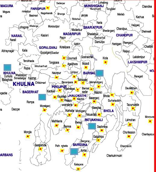
 There were reports of 90 deaths in Patuakhali, 28 in Jhalakathi, 21 in Barisal, 18 in Madaripur, 21 in Gopalganj, 20 in Shariatpur, 12 in Khulna, 24 in Pirojpur, 13 in Bhola, four in Chandpur, three in Munshiganj, six in Faridpur, four in Satkhira, two in Narayanganj and one in Habiganj and Laxmipur each.
Official figures put the death toll at 233 in 19 districts, which exclude Barguna, Pirojpur and Jhalakathi.
Acting Secretary at food and disaster management ministry, Mohammad Ayub Miah, disclosed the casualty figures at a press briefing at PID conference room this afternoon.
There were reports of 90 deaths in Patuakhali, 28 in Jhalakathi, 21 in Barisal, 18 in Madaripur, 21 in Gopalganj, 20 in Shariatpur, 12 in Khulna, 24 in Pirojpur, 13 in Bhola, four in Chandpur, three in Munshiganj, six in Faridpur, four in Satkhira, two in Narayanganj and one in Habiganj and Laxmipur each.
Official figures put the death toll at 233 in 19 districts, which exclude Barguna, Pirojpur and Jhalakathi.
Acting Secretary at food and disaster management ministry, Mohammad Ayub Miah, disclosed the casualty figures at a press briefing at PID conference room this afternoon.
Red Crescent fears toll may top 10,000 Crisis of drinking water; relief inadequate; diarrhoea, hunger spread
Government's disaster preparedness (warning) may have save some lives but not livelihoods
Low-lying areas of many coastal districts were inundated as storm surge whipped by raging winds washed the areas. "It was the worst nightmare of its kind I have ever experienced," a Patuakhali police official quoted an elderly man as saying while narrating the nightlong horrors. Thousands of people were injured in the south and south-western regions and most houses there were either fully or partially damaged in the cyclonic storm, one of the worst in the country.
In Bagerhat, road communications with all upazilas, including Swarankhola, Mongla and Morelganj, remained disrupted. What happened to the residents in Dublar Char, including thousands of fishermen, could not be known as local administration failed to contact them. A coastguard team from Mongla set out for the offshore island in the morning. One trawler, some passenger- and fishing-boats sank in the Mongla port channel, officials said. A Sundarbans forest official told UNB that the cyclone wreaked havoc in the mangrove forests at the "first hit". "Our offices were damaged, boats capsized or washed away," he s
Sidr survivors protest at inadequate relief supply
 Several hundred Sidr victims in Barguna staged a silent demonstration on Wednesday against not getting enough relief for survival.
‘The local government representatives are not giving us sufficient relief goods,’ was the main complaint of the more than 400 destitute people coming from Khajurtala village of Gaurichanna union under sadar upazila of the district.
They demonstrated in front of the Barguna Press Club holding banners for hours and asking the authorities for adequate supply of relief materials to their localities.
Several hundred Sidr victims in Barguna staged a silent demonstration on Wednesday against not getting enough relief for survival.
‘The local government representatives are not giving us sufficient relief goods,’ was the main complaint of the more than 400 destitute people coming from Khajurtala village of Gaurichanna union under sadar upazila of the district.
They demonstrated in front of the Barguna Press Club holding banners for hours and asking the authorities for adequate supply of relief materials to their localities.
The demonstrators, who said they had received only 1.5 kilograms of rice per head since the cyclone, left the scene at around 1.00pm.
But, when contacted, the deputy commissioner of the district, Altaf Hossain, said there was no scarcity of relief goods and everyone was getting relief goods that were adequate for one’s survival.
‘We sent more supplies to the worse affected areas than the less affected ones, which may have caused resentment among the residents of the latter localities,’ Altaf Hossain told New Age.
An elderly resident of Barguna told New Age by phone that he had information that the supply of relief to many of the affected areas, like Raybhogh and Charakgachhia in Nali union, was still inadequate. He said nearly 1,000 homes and a market were completely washed away in Nali, but the survivors had received only 10kg rice per family in the last 13 days from the local UP chairman.
 The police on Sunday detained 12 people when they were out on demonstrations seeking relief at Sonarbangla of Gaurichanna in Barguna.
Witnesses said about 200 people brought out a procession in the village, some 6km off the district headquarters, in the morning. Holding banners and festoons, they demanded food and clothes and marched towards the town before being stopped by the police at Khejurtala, four kilometres off the town.
The police on Sunday detained 12 people when they were out on demonstrations seeking relief at Sonarbangla of Gaurichanna in Barguna.
Witnesses said about 200 people brought out a procession in the village, some 6km off the district headquarters, in the morning. Holding banners and festoons, they demanded food and clothes and marched towards the town before being stopped by the police at Khejurtala, four kilometres off the town.
The police snatched away the banners and festoons and asked the marchers to go to the office of the deputy commissioner to place their demands.
The police led a group of 12 demonstrators, took them to the Barguna police station and detained them, some demonstrators alleged. A large number of women also joined the demonstrations.
Leaders of various political parties denounced the arrest of 12 people in Barguna on charge of rallying for food and the remark of the communications adviser, MA Matin, that the government would go tough against any such demonstrations and politicisation of relief activities. They told New Age that it was unbecoming of the government to show such an attitude towards cyclone victims and suggested that the government should not take any heavy-handed measures (New Age, December 3, 2007).
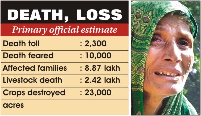
 The Cyclone Sidr apparently held the real degree of its destruction in store for the nation until yesterday, four days into the catastrophe, with the government gradually raising the death toll to 2,300 and Red Crescent fearing causalities as high as 10,000.
Four days into the hurricane, in Majher Killa, the furthest corner of Dublarchar and the worst-hit area, still reeling from the devastation with bodies being recovered; and the need of the moment is water. Eight more bodies were found here and many more are feared buried deep in the forest.
A man standing there picks up the grains and shows us. "This is what we are left with," he says. A bad stench assails our noses rice rotten by water mixed with sand. "We can't eat this. If you eat, you will be like him," and he shows a man sitting under a tree looking lifeless. The man has diarrhoea since last night and is dehydrated by now.
"Do you have some water? Just a little?" asks a boy. "We don't have any pond left."
But just a few feet from him is a big pond full of clear water. "What about that?"
"No, you can't drink that. It is now sea water."
Already a group has formed around us. They look at us with pleading eyes. "Water? Any water? Please!"
"We waited for four days for a trawler to send his body home," Tushar says. Marks of injuries on his chest. "We did not find a single trawler. So we are putting him to rest here."
And that is the tragedy of Dublarchar today. The man who would control all the trawlers could not find a single one left to carry him home.
But then he was lucky, if it could be called "luck" at all. His body was at least identified and buried. We find four more bodies, all floating in the canals of the Sundarbans. One tangled in a net and another stuck to a tree. People are still trawling the ponds in search of their missing ones.
As we walk back from the cyclone shelter, we find a silent column of people walking behind us. Then they catch up with us. "Please take us with you,
just put us on some road, we want to go home," they whisper.
"Please give us some water, please! Please give us some food! Please! Please! Please!"
We know we have no control over these things. We are just some helpless journalists going from one water marooned place to another, and then to a ship anchored in the middle of the bay.
We start walking faster. We are now fleeing from the haunted island (Daily Star, November 19, 2007).
The Sidr havoc- 'environmental refugees'
Who knows if the last 15th November's devastating hurricane (named Sidr) attack on the south and south-west of Bangladesh is not at least partially caused by the recent environmental changes that are largely a product of human actions? This single havoc killed about five thousand people (very conservative estimate in contrast to Red Crescent's estimate of 10 thousand deaths), millions of trees, thousands of wild animals and millions of cultured chickens and prawns. I am not speaking of human dwellings or social institutions.
Why so many people live in the coastal area and in many thatched houses prone to destruction even by a strong wind, let alone such tidal and stormy surge? They are over users of the fisheries and forests there. So there are many funding agencies to 'help them with loans', though in payment of high (one said 16% in a BBC interview) rate of interest.
Besides, they have no other way; they have been driven away from their parental/self-made homes by river erosion, construction of dam or embankment, or industrialization and urbanisation in certain areas of the country. These people can perfectly be called 'environmental refugees' a term popularised by Andrew Simms since 2003.
Number of environmental refugees will surpass the political ones by many folds and it may prove unmanageable by any single international body. So, preventive measures are far better. That is, we need to compete with environmental changes through every means and we must “get on top of the problems before they get on top of us” as Dr. Myers suggested.
Climate-linked migration may trigger conflict
Climate change poses a big threat to a total of 46 nations and 2.7 billion people putting them at high risk of being overwhelmed by armed conflict and war.
"A further 56 countries face political destabilisation, affecting another 1.2 billion individuals," this stark warning will be outlined by the peace group International Alert in a report, A Climate of Conflict, to be released this week.
The report reveals that much of Africa, Asia and South America will suffer outbreaks of war and social disruption as climate change erodes land, raises seas, melts glaciers and increases storms. "Even Europe is at risk."
The report states, "A different situation affects Bangladesh. Here climate-linked migration is already triggering violent conflict."
"Droughts in summer combined with worsening flooding in coastal zones, triggered by increasingly severe cyclones, are destroying farmland in Bangladesh. Millions have already migrated to India, causing increasingly serious conflicts that are destined to worsen."
"Climate change will compound the propensity for violent conflict, which in turn will leave communities poorer and less able to cope with the consequences of climate change," the report states.
The worst threats involve nations lacking resources and stability to deal with global warming, added the agency's secretary-general, Dan Smith.
"Holland will be affected by rising sea levels, but no one expects war or strife," he told The Observer in London.
"Holland has the resources and political structure to act effectively. But other countries that suffer loss of land and water and be buffeted by increasingly fierce storms will have no effective government to ensure corrective measures are taken. People will form defensive groups and battles will break out."
Peru's fresh water comes mostly from glacier melt water. But by 2015 nearly all Peru's glaciers will have been removed by global warming and its 27 million people will nearly all lack fresh water. In Africa, rivers such as the Niger and Monu are key freshwater resources passing through many nations. As droughts worsen and more water is extracted from them conflicts will be inevitable.
In Europe, most countries are currently considered stable enough to cope with global warming, apart from the Balkans; wars have left countries such as Serbia and Montenegro politically weakened. As temperatures rise and farmland is reduced, population pressures will trigger violence that authorities will be unable to contain.
Some nations on the risk map, such as Russia, may cause surprise. "Moscow's control of Russia as a whole will not be undermined by global warming," said Smith. "But loss of farmland in some regions will lead to local rebellions like those already triggered in Chechnya."
Conflict triggered by climate change is not a vague threat for coming years, he added. "It is already upon us."
Source: The New Nation, November 05, 2007).
Climate change induces migration
The International Alert, a group of experts which works for noting the effects of climate change over the years, has reportedly prepared a report on the subject. Based on data obtained from forty-six countries, which are threatened frequently from climatic change, the report reveals that heavy rains and flooding of rivers have not only damaged habitats but also affected the production of the primary sector of the economy. Millions of people in the affected countries bear the brunt of the destruction of habitats and loss of production.
The report entitled "A climate conflict," may be released this week and made available to relevant agencies and quarters of the society in countries in Asia, Africa and South America. The effects of climate change have already started being felt in many countries. The erosion of land, melting of glaciers, rises in the sea levels and flooding of rivers and riverine areas have affected the life and living of the people. In countries like Bangladesh droughts in the dry season and flooding in the rainy season have repeatedly affected production. The people affected adversely migrate from their parental homes to safe zones, including urban areas for survival. The migration of people to neighbouring territories often leads to conflicting situations. The migration of people from environmentally degraded areas to safe zones and neighbouring countries would increase in the coming years. Concerned countries try to send back the environmental refugees to their countries of origin.
Legal actions taken against the migrants not only affect them but also create tensions between the home countries of migrants and host countries. Millions of migrants in Asia, Africa and South America thus face uncertain future.
Climate change in the world is related to global warming in general and exploitation of natural bounties including water, oil, gas, coal, forests, hills and mountains. The use of energy for industrial complexes by developed countries has increased. They have started updating their technology used for aircraft, ships and industries. The effects of the unrestricted use of energy have started appearing in the form of global warming. The snow in mountains are melting in accelerated rates, water of rivers as well as other natural bounties have already been over-used. As a result, the climatic conditions in the world continue to turn dangerous for human beings, animals and plants. That being so, use of natural resources has to be made sustainable. The flows of water in major rivers should be preserved. Otherwise, the availability of fresh water may be reduced and people in different countries may suffer from different problems including diseases. Environmental migration can be stopped only by slowing the pace of environmental degradation with a view to achieving sustainable development in the long run (Source: The New Nation, November 06, 2007).
Environmental migration to escalate tension in South Asia
Bangladesh could face security threats due to climate change, which is likely to trigger environmental migration and cause escalation of tension between neighbours in the years to come, warns a global report on environmental changes.
The report titled ‘Climate Change as a Security Risk’ says, probable loss of arable and residential lands through flooding in this part of the world will result in increase in internal and external environmental migration and strain relations between countries.
‘The instability in the east of the subcontinent is likely to increase and relationships between the countries [Bangladesh and India] will come under additional strain,’ forecasts the report prepared by the German Advisory Council on Global Change. The issue is likely to become a security problem since, the report explains, the two sides are not prepared to engage in political dialogue.
The report, which is yet to be published, warns that by 2020 the economic situation in Bangladesh is extremely unstable and the country is embroiled in a major political crisis in that decade.
‘Political elite thwart the spread of democracy; urgently needed reforms are put on the back burner. A broad middle class, which could institute economic and political reforms, is extremely slow to develop,’ reads the report.
The annual costs of the damage caused by natural disasters now amount to almost 15 per cent of Bangladesh’s gross domestic product. In 2020, the report mentions, Bangladesh could be one of the countries in which the ‘effects of anthropogenically-induced climate change, floods, drought and coastal erosion are already very clearly visible’.
It says severe floods could overwhelm the capacity of Bangladesh to deal with disasters and ultimately its capacity to provide food for the population, 60 per cent of which is supported by agriculture.
Already as a result of sea level rise, the coastal regions around the ‘gulf of Bengal’ are constantly losing valuable residential land, fertile farmland and coastal ecosystems such as Sundarban.
‘Bangladesh will be particularly severely affected by the effects of climate change,’ the report says citing study findings that production of rice and wheat could fall by 8 per cent and 32 per cent, respectively, by the middle of the century.
‘It is therefore foreseeable that climate change will overwhelm political structures and will further exacerbate economic and social problems.’
The climate change will primarily affect subsistence farmers and slum dwellers in the mega-cities, the report warns adding that such a reality, in combination with awareness of increasing social inequality and inadequate access to social services, will increase the existing susceptibility – arising in part from ethnic and religious tensions – to violently expressed conflict.
In a chapter titled ‘Fictitious confrontation scenario: Disaster management fails’ the report points out that the cross-border migration also gives rise to diplomatic tensions between Bangladesh and India.
‘The political conflict between the two states escalates; India threatens Bangladesh with ‘humanitarian intervention’ on the pretext that the environmental migrants represent a terrorist threat,’ according to this scenario.
It further says that the Ganges delta, which has already been badly damaged by storm floods, offers little resistance to the destructive power of the winds — something which has already been witnessed during the recent cyclone Sidr.
However, in another chapter titled ‘Fictitious cooperation scenario: Crisis management succeeds’ the report foresees growing international concern over security situation, especially New Delhi’s reluctance to enter political dialogue with Dhaka on environmental migration after erection of fence along 4,000 kilometres of border (New Age, Dec. 24, 2007).
No VGF cards, house building loans for thousands in Bhola
Thousands of poor farmers and fishermen in remote chars of Bhola are passing their days in misery, without any assistance to rebuild houses and vulnerable group feeding cards, three weeks after cyclone Sidr pounded the south coasts.
There are allegations of irregularities and nepotism by union council chairmen and members in the distribution of the VGF cards and allocation of loans for rebuilding houses in various places of Bhola, especially char areas.
Visits to some chars, about 100 kilometres off the district headquarters, showed thousands of villagers were struggling after losing their livelihood and their homesteads.
People of Anjuhat at Charfesson, Char Leolin, Char Sikdar, Char Motahar and Char Manohar — all in the south of the district or in the Bay of Bengal and difficult to reach — came in groups to tell their miseries after the cyclone.
Abdul Mannan, an elderly resident of Char Sikdar, told New Age what he received in relief was not enough to feed his family. No job is available too, he said (New Age, December 8, 2007).
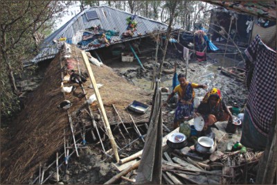
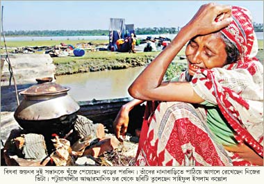
Acute crisis of drinking water
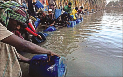 Around 30,000 fishermen at different Sidr-affected chars adjacent to the Sundarbans are facing an acute crisis of drinking water as the November 15 cyclone left badly polluted all the four ponds which used to be the source of potable water for them.
Of the four ponds, three located at Office Kellar Char, Narikelbariar Char and Sholar Char still contain highly contaminated water with no steps as yet for its purification.
Around 30,000 fishermen at different Sidr-affected chars adjacent to the Sundarbans are facing an acute crisis of drinking water as the November 15 cyclone left badly polluted all the four ponds which used to be the source of potable water for them.
Of the four ponds, three located at Office Kellar Char, Narikelbariar Char and Sholar Char still contain highly contaminated water with no steps as yet for its purification.
Water in the other pond, at Meher Alir Char, has been purified to some extent with individual initiative. And several thousand fishermen from nine chars now collect water from this pond every day.
Fishermen at these chars have demanded that the authorities take immediate steps to clean these ponds as diarhhoea has broken out in different areas due to crisis of drinkable water. And any delay in this regard might lead to an epidemic, they feared.
Meanwhile, the administration is providing purified water received as US relief at Maron Char. But fishermen hardly take this water following a rumour that it causes diarrhoea.
At Meher Alir Char Thursday morning, it was found that hundreds of fishermen had already gathered around the eight acre-pond to collect water.
Many of them had come from places 10 to 22km away by boat. Carrying different kinds of water containers, they were standing in long queues.
Dublar Char fishermen led by Major (retd) Ziauddin Ahmed and his brother Kamaluddin Ahmed looks after the pond. They had taken steps to clean the pond and make its water drinkable.
A number of fishermen from Sholar char came to take water from this pond for around 5,000 fishermen at the char, about 30km away. It takes around two hours to come to Meher Alir Char and another two hours to go back.
Maron Char with about 5,000 fishermen living there is about 10km from Meher Alir Char, Majher Kellar Char with about 4,000 fishermen is 4km away while Manik Khalir Char where around 1,000 fishermen now live is 12km away. There are about 4,000 fishermen at Narikelbariar Char which is 22km away, and around 2,000 at Office Kellar Char, 8km away from Meher Alir Char.
And they have to depend on water from this pond.
A number of fishermen said they have got relief materials but they are not getting drinking water. Ziauddin said, "There is hardly any food crisis at these Islands but crisis of drinking water has turned acute. The government should take immediate measurers to purify water of the ponds to end the crisis.” Unless this done as early as possible, diarrhoeal diseases might spread at different chars, said Ziauddin, who was a sub-sector commander in Sector-9 during the Liberation War (Hasan Jahid Tusher, from Meher Alir Char, Sundarbans ; December 8, 2007).The Sundarbans after the Sidr devastation in 2007
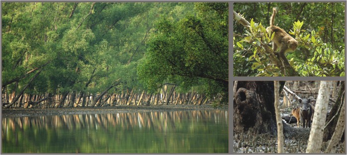 |
The Sundarbans has resuscitated from the Sidr devastation caused about a year ago. The battered forest was a cause for worry for many who thought this world heritage site may be lost for ever. There was no harm in thinking like that -- wherever you went in the mangrove forest, all you could see is fallen trees and mud. Prospect for tourism looked bleak.
 |
But the great forest has sprang back to life with its glory of wildlife. And tour companies are upbeat about revival of the industry. Walk along the Pashur river or go deep into the forest, as our photographer Syed Zakir Hossain did recently, you find the trees in green foliage. And animals scurrying around. The crab eating monkeys diving into the water in search of snails, an amazing sight indeed. The wild boars with their huge tusks moving around in packs. The quick-footed deer scampering into the forest at the presence of tourists. The great adjutant stork slowly winging across the creeks. The huge birds just look fabulous. The greater herons craning their necks to look around at you. The squirrel scamper up the tree trunks and wonderful sight of the woodpecker peeling away at the trees in search of insects. And the Shikra, a bird of prey, wait on a branch looking for smaller birds to pounce on. And then if you are lucky, extremely lucky, you will see the mashed finfoot, an elusive bird. (Z. Hossain, October 28, 2008)
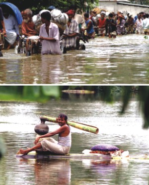
Flood Situation Worsens, August 2007
 In most major religions, cultures and societies around the world there is a tale about a great flood. The stories are all slightly different but the moral remains the same, God (or some higher being) is fed up with the people of the world and the ensuing flood is basically to put them in their place. The most famous story is that of Noah and his ark and that is a story Bangladesh can learn a lot from. When the floods come, pack up your stuff and head for higher ground, but in the great delta very few places can be deemed “higher ground”. What we are left with are disasters of biblical proportions, thousands dead and millions homeless.
The stories of Bangladesh's floods are quite unremarkable depending on their severity they appear every year, and seemingly year after year the nation is left unprepared for them. Why is that the case?
It is either gross negligence or a lack of foresight on the part of the government; it is probably a bit of both.
 Teeming monsoon rains have inundated wide swaths of northern India and neighboring Bangladesh, killing at least 166 people and washing away villages and farmland that 19 million people depend on, officials said Thursday.
With rain-swollen rivers bursting their banks along the fertile plains south of the Himalayas, India sent soldiers to help evacuate people from some of the worst-hit areas.
"I have not seen such flooding in the last 24 years. It's a sheet of water everywhere," said Santosh Mishra, a resident of the Gonda district in Uttar Pradesh, one of the areas soldiers were sent. Authorities urged residents of 65 nearby villages to evacuate.
"There are no signs of houses, temples or trees," Mishra told the local Sahara Samay television channel.
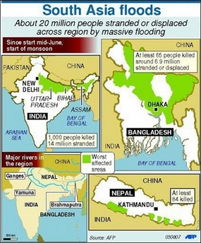
Some 14 million people in India and 5 million in Bangladesh were displaced or marooned by the flooding, according to government figures, with at least 120 people killed in recent days in India and 46 more in Bangladesh (AP, August 2, 2007).
Teeming monsoon rains have inundated wide swaths of northern India and neighboring Bangladesh, killing at least 166 people and washing away villages and farmland that 19 million people depend on, officials said Thursday.
With rain-swollen rivers bursting their banks along the fertile plains south of the Himalayas, India sent soldiers to help evacuate people from some of the worst-hit areas.
"I have not seen such flooding in the last 24 years. It's a sheet of water everywhere," said Santosh Mishra, a resident of the Gonda district in Uttar Pradesh, one of the areas soldiers were sent. Authorities urged residents of 65 nearby villages to evacuate.
"There are no signs of houses, temples or trees," Mishra told the local Sahara Samay television channel.
Some 14 million people in India and 5 million in Bangladesh were displaced or marooned by the flooding, according to government figures, with at least 120 people killed in recent days in India and 46 more in Bangladesh (AP, August 2, 2007).
There are large negative effects of floods on the spatial incidence of poverty. These effects are especially strong in the short term in the immediate aftermath of major floods though there also appear to be longer-term negative effects. However, normal flooding is necessary and beneficial for agriculture, transport and fisheries. The probability of catastrophic flooding in Bangladesh is about once in a decade. Floods can devastate the physical and social capital of societies and destroy whatever tiny amounts of savings poor households have and when these floods are as frequent and catastrophic as they are in Bangladesh and similar flood basins, the effects can be ruinous.
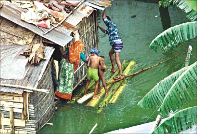
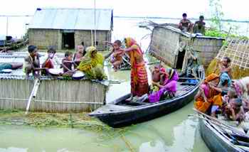
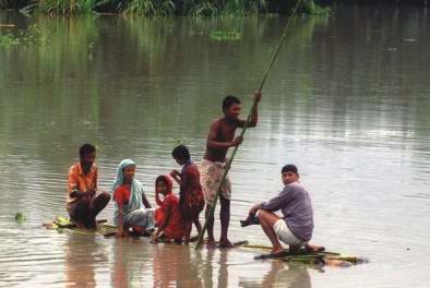
More areas of the central part of the country, including the eastern side of the capital, are going under floodwater, as the Jamuna, Padma, Meghna and small rivers around Dhaka continue to swell at most points. More than a third of Bangladesh, a low-lying delta of 145 million people, has been inundated by floods. Nearly five million people have either been marooned or displaced in the country?s hardest-hit northern region.
Many displaced people have taken shelter on embankments, while others have moved onto rooftops of their houses. Residents are using small boats to move around. The deluge is feared to cause huge losses to the agriculture and bring water-born diseases in its wake.
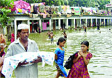
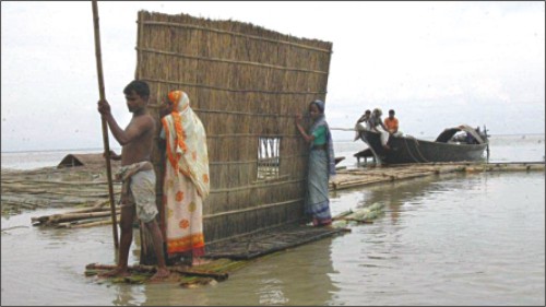 Flood-affected people of Ranigram in Sirajganj dismantle their homes and move to higher grounds yesterday as the flood situation in the district worsens. The flood situation continued to deteriorate in most flood-affected districts yesterday while scarcity of drinking water has become a serious problem for the marooned people exposing them to various water-borne diseases.
Five people, including three children, died by drowning in floodwater in Ullapara and Sadar upazila of Sirajganj yesterday while another child died in Gaibandha.
Flood-affected people of Ranigram in Sirajganj dismantle their homes and move to higher grounds yesterday as the flood situation in the district worsens. The flood situation continued to deteriorate in most flood-affected districts yesterday while scarcity of drinking water has become a serious problem for the marooned people exposing them to various water-borne diseases.
Five people, including three children, died by drowning in floodwater in Ullapara and Sadar upazila of Sirajganj yesterday while another child died in Gaibandha.
Many, mostly the poor, people who took shelter on higher lands and flood protection embankments, are running short of food and have became helpless due to loss of their livelihoods, reports The Daily Star correspondents Hasibur Rahman Bilu and Golam Mostafa Jibon from Sirajganj.
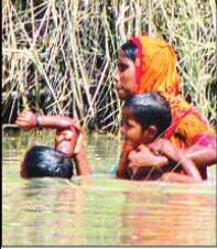
Women and children are bearing the brunt of this crisis as many mothers cannot breastfeed their children.
 Syeda Begum, 20, one of over 12,000 people who took shelter on Ranigram embankment in Sirajganj, said she could not breastfeed her three-month-old boy, as she had nothing to eat for a day.
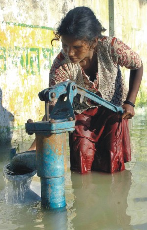
“We have no food left for tomorrow and we are drinking impure water as all the tube wells went under water," said Josna Begum, 60, of Khokshabari in Sirajganj Sadar upazila
Syeda Begum, 20, one of over 12,000 people who took shelter on Ranigram embankment in Sirajganj, said she could not breastfeed her three-month-old boy, as she had nothing to eat for a day.
“We have no food left for tomorrow and we are drinking impure water as all the tube wells went under water," said Josna Begum, 60, of Khokshabari in Sirajganj Sadar upazila
The flood situations in Lalmonirhat, Kurigram, Gaibandha, Rangpur, Netrakona, Sunamganj, Sylhet and Bogra are unlikely to aggravate and may even start improving within the next 24 hours. The situations in Jamalpur, Sirajganj, Pabna and Tangail are still deteriorating and expected to start improving within the next two days.
Floods and poverty are inextricably linked. Over millennia,
people have naturally settled in flood plains and river basins.
The nature of river basins is such that their land is highly fertile,
perfect for intensive agricultural settlements. Indeed, many sites
of civilisation have grown in river basins.
The Nile in Egypt,
the Ganges in India, the Huang He in China, the Mekong
in south-east Asia, and, in modern times, the Mississippi of the
US are examples. Over time, many of these river basins have
developed some of the highest population densities in the world,
with delayed demographic transition consequent to poverty
(Wright, 2005) trapping many such countries in the middle phases. With these growing population densities, the carrying
capacities of the land become strained. Poverty and low education
levels then become prevalent and poverty, environmental
effects and high fertility rates may become locked in a selfperpetuating
cycle
 The water level of the Padma continued to rise at all points and was flowing 122cm and 78cm above danger levels at Goalundo and Bhagyakul. The river is likely to swell further in the next 24 hours.
More areas of Manikganj, Munshiganj, Faridpur, Rajbari, Madaripur, Shariatpur and Dohar and Nawabganj upazilas of Dhaka are likely to be inundated soon.
The water level of the Padma continued to rise at all points and was flowing 122cm and 78cm above danger levels at Goalundo and Bhagyakul. The river is likely to swell further in the next 24 hours.
More areas of Manikganj, Munshiganj, Faridpur, Rajbari, Madaripur, Shariatpur and Dohar and Nawabganj upazilas of Dhaka are likely to be inundated soon.
Small rivers surrounding Dhaka and Narayanganj continued to swell and are likely to approach danger levels in the next day or two. The Buriganga was flowing 82cm below danger level yesterday.
The Meghna at Bhairab Bazar continued to swell and was flowing 25cm above danger level yesterday. The Meghna is likely to rise even further inundating more low-lying areas of Narsingdi, Brahmanbaria and Narayanganj.
Breaching all official estimates, the consumer price inflation has reached a new height at the end of last fiscal year (FY07). Neither the finance ministry nor the central bank has been able to keep the inflation rate within their target.
 There are at least four possible ways in which poor households
might be affected more than non-poor households:
There are at least four possible ways in which poor households
might be affected more than non-poor households:
All four factors can individually and cumulatively lead to the flood-induced spatial or geographic poverty trap referred to earlier, as opposed to non-location specific causes of household poverty.
Although the government has initiated some administrative measures to keep the market prices within a tolerable level, reality checks revealed that these measures have been largely ineffective. Rather, to comply with the international financial institutions like the World Bank and the International Monetary Fund (IMF), the government in April increased the prices of four types of fuel oils, pushing up the inflation risks. Interestingly, both the government and the World Bank argued that the increase in oil prices would not raise the inflation any more. That also proved wrong.
Bhatiali (boatman's) Songs: |

Thousands contract diarrhoea as water starts receding
 Flooding started showing signs of improvement as water in major rivers receded on Wednesday, but the supply of relief goods and medicine to combat waterborne diseases still remain inadequate.
One hundred and ninety-two died in flooding that began in mid-July. About 10 million people in 38, out of the 64, districts have been affected by the flooding, according to official records. The records reported 28 deaths in districts on Wednesday.
Flooding started showing signs of improvement as water in major rivers receded on Wednesday, but the supply of relief goods and medicine to combat waterborne diseases still remain inadequate.
One hundred and ninety-two died in flooding that began in mid-July. About 10 million people in 38, out of the 64, districts have been affected by the flooding, according to official records. The records reported 28 deaths in districts on Wednesday.
At least 18,301 people suffering from diarrhoea were admitted to hospital in the eight days because of a lack of pure drinking water, according to health office sources.
About 6,500 people have been suffering from respiratory tract infections and skin and eye diseases for about a week, and 8,441 people have suffered from waterborne diseases till Wednesday.
‘The situation is alarming,’ said a physician at the largest diarrhoea hospital in Dhaka. About 700 patients were admitted to the hospital on Wednesday. The number of such admissions ranges between 300 and 400 on an average a day.
Saima Sultana has got no time to wail over the death of her two daughters. She has to attend two sons now fighting for life in the ICDDR,B hospital bed.
Flood has shattered the life of Saima and her rickshaw-puller husband, Arifur Rahman. All happened in just a couple of days.
‘Flood has swallowed one of my daughters today and the other one died for want of water yesterday. Now I am fighting to save my two sons,’ said Saima from capital’s outskirts Beraid that remained inundated for the last 10 days.
 Scores of diarrhoea, pneumonia and typhoid patients thronged various hospitals, especially the International Centre for Diarrhoeal Disease Research, Bangladesh (ICDDR,B) and Dhaka Medical College Hospital (DMCH) yesterday compelling the authorities to engage more doctors and staffs to cope with the situation.
ICDDR,B authorities said around 600 to 700 diarrhoea patients are coming to the hospital every day.
A large number of children suffering from fever, pneumonia and skin diseases were rushed to DMCH, Sir Salimullah Medical College Hospital, and Dhaka Shishu Hospital yesterday.
Scores of diarrhoea, pneumonia and typhoid patients thronged various hospitals, especially the International Centre for Diarrhoeal Disease Research, Bangladesh (ICDDR,B) and Dhaka Medical College Hospital (DMCH) yesterday compelling the authorities to engage more doctors and staffs to cope with the situation.
ICDDR,B authorities said around 600 to 700 diarrhoea patients are coming to the hospital every day.
A large number of children suffering from fever, pneumonia and skin diseases were rushed to DMCH, Sir Salimullah Medical College Hospital, and Dhaka Shishu Hospital yesterday.
A correspondent in Faridpur reports: Over 500 people have been infected with water-borne diseases in the district and the number is climbing. There is a shortage of oral saline in the flood-hit areas. Scarcity of food and drinking water remains in the remote flood-affected areas (Daily Star, August 10, 2007).
Unprepared for a Predictable Disaster
The truth of the matter is that there is a lack of planning and coordination from the government. Since the floods of the late 80s many studies have been carried out and the findings of those research initiatives were mixed. They did not fully back embankments and there was even a mini slogan “live with floods”. What came out of it all was strategic embankments. And for the first time drainage was brought to the limelight and was to play a major role in saving many areas from floods.” But while strategic embankments were the way to go forward the issue of drainage took a back seat. In fact one might even say it was swept under the rug. There was to be an all-encompassing method to save the country from floods and that was hailed as embankments.
With the population exponentially increasing over the past 30 or so years the simple fact is that now people live where traditionally floods have taken place. Coupled with that is the fact that government and business installations have increased round the country and gone to remote places, even those need to be saved now.
The vaccines and medicines to treat water borne diseases such as cholera, dysentery, typhoid, jaundice and obviously diarrhoea should be available in stocks in flood prone areas, rather than sending them out there after the floods have started. Sanitation is also a huge problem in rural Bangladesh when the floods roll by. Tube wells are used around the country and when the floods come the water comes by and contaminates them. They should be properly taken care of by taking the tap off and sealing the pipe so as to keep the integrity of its water safe
200 years ago there was always efficient water management. The British came and handed down those duties to the landed gentry aka the zamindars and our problems were created. Since then things have not been the same. What has also not helped in the massive increase in population, people have now moved into the flood plains to live. If that happens of course they will be affected by the floods. The floods have been going on since time immemorial the areas that were traditionally flooded the same areas are flooded now, the only problem is that people live there now. Even more interesting is that before the strain of rice grown could handle floods, now we have all these high yield varieties, which cannot take excess water. This causes some of the food shortages. The problems are all very simple to understand (Ainun Nishat. August 2007)
Crisis of drinking water
 With the flood waters receding, incidence of various types of waterborne diseases is rapidly increasing. Each day people afflicted in the low lying peripheries of the capital city throng ICDDR,B, the premier centre for treatment of diarrhoea and cholera in the country. On 14 August the centre registered the highest number of patients in a day since its establishment 47 years ago.
If this is the situation in around the capital city one can well imagine as to what it would be like in the inundated rural areas of the country. The government's monitoring cell has identified as many as 1526 unions and 217 upazilas as being seriously affected by water-borne diseases. These figures are based on reported cases, so that the actual magnitude of the incidence may be bigger.
We are in the dark as to the status of other waterborne diseases like typhoid, hepatitis, viral fever, pneumonia, skin diseases and conjunctivitis.
Urgent attention should be given to ensure availability of safe and clean water by repairing the cross-leakage between the water supply network and sewer lines. This measure along with free supply of water purification tablets and clean bottled water should result in drastically reducing the incidence of diseases.
In dealing with diarrhoea, cholera, typhoid, hepatitis we need a steady supply of ORS, IV saline and different kinds of antibiotics respectively. It is not enough to say that the factories are working overtime and stocks are sufficient, what is more to the point is their timely distribution to the affected people.
Enough water purification tablets should be available to every household before the flood comes. Understandably, lack of safe drinking water is the main cause of widespread diarrohoea in the flood-affected areas in Bangladesh. Flood in Bangladesh, among other things, is always associated with monsoon rain, and I do not understand why the ICDDR,B or the Disaster Management Bureau does not advise the flood-marooned people to store rainwater for drinking and cooking purposes during the crisis period lasting hardly one to two weeks. This is probably the safest source of water (after a couple of minutes of shower) at hand in such a situation. It may be mentioned here that almost the entire requirement of freshwater for drinking and cooking is met from storing rainwater in the Maldives.
Tornado ravages Southern Bangladesh September 21, 2006
1,500 still missing in Bay
Navy, Coast Guard continue rescue operation; 46 bodies recovered so far; tornado ravages 200 houses in Hatia
September 21, 2006
Will the missing fishermen come back? Who will answer this question? These apparently lost people were the bread earners of their families.
Hope fades fast for more than a thousand fishermen who have remained missing since hundreds of boats and trawlers went under during the violent storm in the Bay on Tuesday (Sept. 23, 2006, Daily Star). Global Warming will displace 2/3 of 140 million population 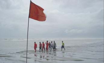 At least 1,500 fishermen remained missing in the Bay for the third day yesterday while 21 more bodies of storm victims were recovered as the low turned into a land depression and moved towards the west of the country.
Meanwhile, a tornado ripped through eight villages at Hatia upazila of Noakhali yesterday morning, destroying more than 200 houses and injuring some 25 people. Since the heavy storm on Tuesday evening, 46 bodies have been recovered from the coastal areas, said official sources. Different private TV channels reported that at least 73 bodies were recovered till yesterday evening.
The government has yet to take comprehensive measures to rescue the missing fishermen. A team of the navy however was searching for the officer who went missing during the storm. There was no trace of him as of late last night.
At least 1,500 fishermen remained missing in the Bay for the third day yesterday while 21 more bodies of storm victims were recovered as the low turned into a land depression and moved towards the west of the country.
Meanwhile, a tornado ripped through eight villages at Hatia upazila of Noakhali yesterday morning, destroying more than 200 houses and injuring some 25 people. Since the heavy storm on Tuesday evening, 46 bodies have been recovered from the coastal areas, said official sources. Different private TV channels reported that at least 73 bodies were recovered till yesterday evening.
The government has yet to take comprehensive measures to rescue the missing fishermen. A team of the navy however was searching for the officer who went missing during the storm. There was no trace of him as of late last night.
You've set me adrift
You've sunk me
The endless waters have no shore
Limitless, with no shores, the waters have no banks
O row with care boatman, my riven boat.
No Advance Warning, the Poor Fishermen Die
 No advance warning of Tuesday’s storm by the meteorologists caused the huge loss of lives and property in the coastal belt where most people depend on fishing in the Bay to earn their living, the disaster management ministry observed on Thursday (21. 09. 06). The ministry of disaster management at an emergency meeting on Thursday expressed its resentment at the weather forecast which did not mention any possibility of the sudden storm (New Age Sept. 22, 2006). The weather forecast are good for port users but to ordinary people these are unintelligible. While our disaster preparedness on the ground has been a success to a great extent we must gear up the forecasting system that will enable us to reduce deaths and destruction caused by such storms. The eight-hour gap between weather bulletins will have to be reduced to a maximum of three hours. It is our belief that given the current global awareness on natural disasters following the massive loss of life and widespread destruction caused by Tsunami, international assistance could be easily forthcoming in modernising our weather and storm warning systems.
 People devastated by Tuesday’s storm in the coastal region came down heavily on the weathermen for ‘wrong reading of the sharp change in weather.’
Wajed Ali, 60, in the fishing trade from the time he was in his twenties, held the weather office responsible for the huge loss of lives and property along the coast. ‘On several occasions, I went fishing in deep sea with Signal 3 or 4 flagged. People in the coast do not bother about lower signals and work as usual in such conditions.’
‘But Tuesday’s situation could in no way be flagged with Signal 3. It should be at least Signal 9 or 10. The reading was absolutely wrong,’ the fisherman said.
People devastated by Tuesday’s storm in the coastal region came down heavily on the weathermen for ‘wrong reading of the sharp change in weather.’
Wajed Ali, 60, in the fishing trade from the time he was in his twenties, held the weather office responsible for the huge loss of lives and property along the coast. ‘On several occasions, I went fishing in deep sea with Signal 3 or 4 flagged. People in the coast do not bother about lower signals and work as usual in such conditions.’
‘But Tuesday’s situation could in no way be flagged with Signal 3. It should be at least Signal 9 or 10. The reading was absolutely wrong,’ the fisherman said.
‘I heard the news of Signal 3 in the afternoon and it was the same at night. The wind speed intensified at about 9:00pm. And in an hour, the landscape in the chars changed.’
‘I have been living on the coast for 30 years and faced Signal 10 several times. But none of the situations was as horrific as was Tuesday’s,’ he(fisherman Zainul) said. ‘I never saw waves 15 to 20 feet high.’
While any serious official attempt to rescue fishermen caught in Tuesday’s devastating storm was too rare to find, an eight-strong group of fishermen freed at least 50 of their fellows from the clutch of the hungry seas.
The eight fishermen led by Abdul Jalil aboard FB Nazma saved others putting their own lives at stake, hauling them on board from the raging waters.
On the darkest night of their life, the sudden change of weather scared the hell out of the eight fishermen on the fishing boat and they started a frantic return journey towards the shore about 50 kilometres away.
Within seconds, the sea became even more riotous with mountainous waves and heavy downpours blinding them so that they could not see even their own bodies.
‘I’ve never seen such darkness. I could not see even my hands,’ Jalil described.
He said although they were trying to steer the boat towards the shore but it was tough for him to determine in which direction the coast lied (New Age, September 25, 2006).
The AL (Opposition Party) president demanded formation of a parliamentary committee to investigate why fishermen were not alerted by the weathermen and why locals were not evacuated before the storm struck.
Asma did not get promised Eid Sari
 Eid is the festival, when everyone get a new cloth. The most circulated Daily Newspaper "Ittefaqque" writes today (18.10. 06) from Kalapara, Patukhali that Noor Hawlader along with 70 fishermen did not return since September 17, 2006. Asmas father promised to buy a sari after his return. Asma and others in the village have fallen in a grief.
Still this village looks towards that village
Quitely trying to hear.
Sitting so still, the word so softly
.......
Over the field weeps the kolmi creeper
The lonely pea-flower weep.
Jasim Uddin The field of the embroidered quilt
LOWLANDS FLOODED IN RAJSHAHI
Heavy rains throughout the day flooded many low-lying areas of Rajshahi, Chapainawabganj, Naogaon and Natore districts. Due to a sharp rise in the water level in the Padma, a 17-kilometre stretch of the Padma Dam between Godagari and Charghat upazilas of Rajshahi was at the risk of being split open. The authorities have been dumping stone blocks and sandbags at vulnerable points to resist the surging water. Lowlands in 25 unions across six upazilas of Rajshahi and Chapainawabganj districts have gone under water.
 Masuma's home is a bamboo and polythene shack in one of the hundreds of slums colonising every square metre of unbuilt land in Dhaka, the capital of Bangladesh.
Masuma is an environmental refugee, fleeing from the floods which have always beset her homeland but which are predicted to strike more severely with climate change. She has found her way to the city from the rural district of Bogra - a low-lying area originally formed from Himalayan silt where the landscape is still being shaped by the mighty Brahmaputra river as it snakes and carves through the soft sandy soil. "In Bogra we had a straw-made house that was nice. When the flood came there was a big sucking of water and everything went down," Masuma says.
"Water was rising in the house and my sister left her baby upon the bed. When she came back in, the baby was gone. The baby had been washed away and later on we found the body," she recalls.
Sir Nicholas' approach is criticised by some economists who argue that as climate change is beyond human control we should continue to maximise economic growth so we will be able to afford to pay for adaptation in the future. In a recent article for the Spectator magazine, former chancellor Lord Lawson argued: "Far and away the most cost-effective policy for the world to adopt is to identify the most harmful consequences that may flow from global warming and, if they start to occur, to take action to counter them." (BBC, September, 2006)
Climate fears for Bangladesh's future
Java tsunami toll at 550
 An aftershock in Indonesia’s tsunami-ravaged region sent hundreds scrambling for high ground on Wednesday as the toll from Monday’s disaster climbed to 550.
Rescuers pulled bodies from the debris and aid trickled into worst-hit Pangandaran town while a search continued for about 275 people still missing after the tsunami smashed into a 300-km (185 mile) stretch of coast along southern Java.
Indonesian media questioned why there was no warning ahead of Monday’s killer waves despite regional efforts to set up early alert systems after the massive Indian Ocean tsunami of 2004.
An aftershock in Indonesia’s tsunami-ravaged region sent hundreds scrambling for high ground on Wednesday as the toll from Monday’s disaster climbed to 550.
Rescuers pulled bodies from the debris and aid trickled into worst-hit Pangandaran town while a search continued for about 275 people still missing after the tsunami smashed into a 300-km (185 mile) stretch of coast along southern Java.
Indonesian media questioned why there was no warning ahead of Monday’s killer waves despite regional efforts to set up early alert systems after the massive Indian Ocean tsunami of 2004.
The Jakarta Post said in an editorial the disaster agency had done ‘nothing of note to increase people’s preparedness for disasters’ . Government officials said as many as 54,000 people were displaced from wrecked fishing villages, farms and beach resorts, adding to the rehabilitation headache for authorities after an earthquake that killed more than 5,700 people in central Java less than two months earlier.
(Reuters, Pangandaran, Indonesia , July 20, 2006).
CONTENT
1. INTRODUCTION
2. FLOODS
2.1. North East India 2. 2. Floods in the Mekong basin, Himachal, Nepal
2. 3. Bangladesh- 2004
2.3.1. 20 million people in Bangladesh have been left homeless 2.3.2. Mass migration to slums of Dhaka 2.3.3 Waterborne Diseases 2. 3. 4. North East Bangladesh 2. 3. 5. Flood in Southern Coastal Districts 2. 3. 6. Trading on Human Misery 2. 4. Causes of Devastating Floods 2. 4. 1. Rapid Economic Development and Urbanisation
3. DESERTIFICATION and DROUGHT 4. WARN OF A GREAT HIMALAYAN QUAKE
5. TROPICAL CYCLONE
The floods today in 2004, therefore, are both a product of the flood control projects and also a good reason to prepare more projects in similar line. With the money taken from people's pocket, the flow of water is blocked, rivers are destroyed, the overflow of water become disastrous, water-logging become permanent, and the results are all around us.
Deforestation and soil erosion have already taken a savage toll of lives in the Indian subcontinent. As the slopes of Himalayas are cleared for habitation and agriculture, severe flooding is increasing throughout northern India, Nepal, Pakistan, and Bangladesh. These countries experience almost every year both severe flooding and subsequently drought. Deforestation in the Himalayas has been responsible for the flood disaster in the lower reaches of the Ganges-Brahmaputra and the higher incidence of flooding that has occurred since 1940; apparently flooding now affects some 18 x 106 ha of land as compared with 6 x 10⁶ ha in the early 1950s A large-scale irrigation system does simplify habitat resulting in an immediate reduction in the number and species complexity of both plants and animals. With the abolish of original trees and shrubs, shaded habitats are replaced by those exposed to sunlight. The shaded habitats are replaced by those exposed to sunlight. Simplification of the habitat results in the loss of plant groupings and zonation and their replacement by a sharp transition between the crop and field boundary. Irrigation schemes directly increase the acreage of above-ground water beyond the main impoundment. Such irrigation scheme is responsible for supporting large mosquito populations capable of transmitting disease agents. The flood prevention on the other hand shows a degrading quality of crops production. It is known in industrial countries that the quality of food is seriously degraded due to the use of agrochemical. Now 80 million and 20 million population of Bangladesh and India are poisoned by ground warter arsenic contamination. Terrestrialization of the semi-aquatic landscape of Bangladesh has the principal objective of intensification of agriculture to satisfy the "need" for foodgrain self-sufficiency. Yet as the human population becomes increasingly marginialized and landless, the survival strategies of those at the bottom have increasingly fallen back upon the remaining physical and biological diversity of regional ecosystem.... In so far as the poorest of the rural poor continue to eke out these (precious) livelihoods... bio-diversity reducing hydrological manipulations will make some human lives all the more precarious..... The loss of habitats has been so significant that little can now be done to restore the balance in the areas. The issue is not just of water quantity, but of water quality and socio-economic conditions of stakeholders. It is this more complex, subtle concept of scarcity that is the basis of the analysis of the situation in rural Bangladesh. It does not have the simple attractiveness or dramatic impact of many of the more conventionally used measures, but it does have one over-riding advantage: it provides a basis for understanding local-level reality that conventional measures do not.
Bangladesh also suffered flooding during 1998 as two months of rain inundated two-thirds of the country. Officials have said the death toll from more than two months of flooding passed 1,000 and could keep rising if a looming diarrhea epidemic is not contained. Diarrhea, caused by polluted water or rotten food, accounted for 227 of the 1,040 deaths caused by the disaster, the worst flooding in Bangladesh's history, officials said. Other deaths were caused by drowning, snakebites, collapsing houses and mudslides, disaster management officials said. The floods have destroyed crops worth $300 million and damaged close to 10,000 km (6,200 miles) of roads. Flooding is a natural phenomena that will always occur on a regular basis and it is part of the cycle of a river. No matter what protection techniques are used floods will always cause damage and, with the increase of urban areas on the flood plain, more people are within the flood prone areas of the world. It is also important that with all the techniques that engineers have developed that people do not feel complacent and the river has been tamed and they are safe as this is not the case.
NEW DELHI, Aug 4:–As international aid organizations accelerate relief efforts to help millions of people stalked by hunger and disease in flood ravaged Bangladesh, they warn that the country is hovering on the brink of another devastating flood ,writes Rahul Verma of One World South Asia
With life virtually grinding to a standstill as the country faces its worst flood in the past six years, experts caution that the worst is not yet over. The United Nations organization, World Food Programme (WFP), fears Bangladesh may face a "cataclysmic" flood in mid-August, when the already-waterlogged region will fail to drain the next bout of monsoon rains. The worst is not yet over as thousands of flood victims could die of disease unless urgent precautions are taken, relief workers from the World Health Organisation and other bodies warned yesterday.
Health experts repeated their cautions against an epidemic outbreak in the deluge-ravaged areas, while an official with the United Nations, asking not to be named, told official news agency BSS (August 5, 2004): "The situation is quickly heading towards the worst and it may go beyond control." A large swath of the area inside the Dhaka-Narayanganj-Demra (DND) embankment faces permanent waterlogging because of unplanned urbanisation at the cost of proper drainage system.
Fifteen days after the heavy rains that left the area reeling under four to five feet of water, many low-lying areas are still waterlogged. Water and Sewerage Authority (WASA) officials fear stagnant water might become a permanent feature of these localities. Residents of Konapara, Basherpool and Dholla do not have to wade through logged water now, but East Boxnagar, South Boxnagar and several low-lying areas such as Bank Colony, Hajinagar, Barabangha, Dogaior and southern part of Matuail of Demra are still under knee-deep water.
Moreover, Shanarpar, Nemaikashari, Bagmara, Kadaltali, Rasulbagh, Jalkuri, Bhuigarh, Delpara, Lamapara, Tusharpara, Pathantali, Godhnail and Kadamtali of Siddirganj thana in Narayanganj district are also waterlogged. The DND dam area goes under water every monsoon because of near absent drainage system, but this time around the situation became really bad because of record rainfall between September 12 and 15 (Dqaily Star, October 6, 2004).. The UN says more than two-thirds of the country (Bangladesh) is underwater and is warning of a humanitarian crisis.
(BBC, 28. 07. 04) Normal floods are considered a blessing for Bangladesh-providing
vital moisture and fertility to the soil through the alluvial silt deposition. Only abnormal floods are
considered disastrous, i.e., the high-magnitude events that inundate large areas, and cause widespread damage to crops and properties.
During the peak flow season (July, August and September), most of the rivers overflow their banks, and deposit silt on the flood plains -
providing vital moisture and fertility to the soil. Thus, the normal floods are considered a blessing for Bangladesh. Flooding in Bangladesh is a regular occurrence; about 26,000 sq. km or 18 per cent of the country is flooded every year by monsoon rains. But Bangladesh faced severe floods in 1954, 1955, 1956, 1962, 1964, 1966, 1969, 1970, 1971, 1973, 1974, 1985, 1987, 1988, and 1993. The severe 1988 floods were generated by intensive rainfall that extended over North and North East Bangladesh, India, Nepal and Bhutan, the most intense local concentrations being in Assam, Meghalaya, Bhutan and Arunachal Pradesh. The Ganges and the Brahmaputra rivers drain an area inhabited by 500 million people. A tenth of the population of our planet faced the catastrophic events of 1987 and 1988 floods which led to widespread destruction, misery and loss of life. The flood in 1988 affected nearly half of the population and over 60 per cent of the net cultivable land. A joint UN/Government of Bangladesh has estimated the cost of "Reconstruction and Rehabilitation Programme" at U.S. dollars 1.1 billion. It is estimated that the food grain loss was about two million MT compared to annual food grain production in a normal year of over 12 million MT. Flood is more or less a recurring phenomenon in Bangladesh, and often within tolerable limits.
Occasionally, it becomes devastating. In 1997, 1988, 1998, and 2000, Bangladesh faced unprecedented floods, causing
massive loss of life and property During the peak flow season (July - September) most of the rivers normally overflow their banks
onto the low-lying surrounding flat land, which is essential for providing vital moisture and fertility to the soil. However, occasionally abnormal conditions lead to drainage congestion, excessive rainfall run-off, and storm-tidal surges that induce high-magnitude flooding that inundates large areas, and causes widespread damage to crops and
property. The mean annual rainfall in Bangladesh varies from about 1400 mm. in the western part of the
country, to almost 5000 mm. in the northeast region. There are wide seasonal fluctuations, with
about 90 per cent of the rainfall occurring during the four months of the monsoon period (June-
September). This is the worst flooding in recent memory with 22 of the 24 districts in Assam under floodwater," Assam Chief Minister Tarun Gogoi told AFP.
"The high water current has washed away rows and rows of villages. The condition of the people is really devastating."
About 3.7 million people have been displaced with an estimated 3,200 villages under water, a flood control official said. The Brahmaputra River which criss-crosses the state was flowing at least 1.5 to 2.6 meters (5.00-8.25 feet) above the danger level. Several parts of the state remained cut off as floodwaters swamped highways and created craters.
Hundreds of thousands of people were taking shelter on raised bamboo stilts and on mud embankments, with some trapped on rooftops of their mud-and-straw huts. "A vast stretch of the Kaziranga National Park has come under floodwater and in some areas the water level rose to about five feet (1.5 metres)," H.K. Bhuyan, a park ranger, told AFP. Monsoon is here with all its devastating effect. Flood waters are overrunning all major habitats in adjoining Assam and the north of Bangladesh. It is indeed, ironic, that Bangladesh and India are continuing a long feud over the distribution of fresh water when it causes so much damage to both, annually. The argument for India is that the eastern part of the subcontinent and the monsoon is water-surplus while the west and the rest of the year is short of it. There is very little that can be done about nature’s ways except perhaps holding back the rain water which has been a part of culture in the western part of the subcontinent for centuries In the north-eastern Indian state of Assam, all but one of 27 districts are battling the floods, and over 100 people have died, officials say.
Millions are homeless and crops, homes and roads have all suffered huge damage. Millions of people have been badly affected and essential supplies are running low.
"There is an acute scarcity of baby food and over 500,000 babies affected during the floods are starving," Assam Health Minister Bhumidhar Burman said (BBC, 27. 07. 04). The latest floods in the Mekong basin - said to be the worst in decades - have been blamed on logging in Tibet that has left vast swaths of the Chinese-controlled region denuded of forest cover. The tragedy echoes devastating floods on the Yangtse in 1998 that prompted the Government to introduce limits on logging in the river's upper reaches. Indiscriminate tree-felling destabilises topsoil, which is washed by rain into rivers, raising the water level and diminishing the rivers' ability to absorb annual rains. "Projects to build dams and reservoirs to harness Tibet's rivers for hydro-electricity schemes to power western China have caused fragmentation of ecology and fish species and finally extinction to already endangered plant and aquatic species," the report says. More than 100 people were reported to have died in flash floods in the northern state of Himachal Pradesh earlier this week.
The River Sutlej, which runs through the state, was reported to have risen to more than 40 feet above its normal level in some places.
Dozens of bridges were washed away, leaving villages stranded. The local authorities have asked the central government for a grant of about $200m.
It has approved less than a quarter of the amount.
The Sutlej river, which normally runs in a deep gorge, overflowed in a matter of minutes. The Flora and Vegetation of Nepal The flooding inundated 40 of the 64 districts and left about 30 million people homeless or cut off. The cost of the damage to property and infrastructure was put at 6.6 billion dollars. As many as 2,59,938 people took refuge in 227 temporary shelters in the capital (Daily Star, August 2, 2004). Monsoon flooding triggered by days of torrential rains and raging torrents cascading down hills across the border marooned several lakh people, displaced many more and destroyed crops in the fields in 15 districts yesterday. At least three people including a girl drowned in floodwaters in Sherpur, Bhola and Sirajganj and fierce-flowing rivers ate metres into their banks in the northern, northeastern and southern districts, making thousands of people homeless. A man was missing after a boat capsize in Sylhet. The meager relief the flood hit people so far received was mostly distributed by some social service oriented and private organisations. Government's share in the relief operation is very negligible, as its coordination and monitoring activity have totally broken down at the field level (The Bangladesh Observer, 30 July, 2004). The prices of food items and vegetables have already been sources in the hats and bazars of the district The low-income groups of people have been worst hit by the upward swing in the prices of daily necessities of life. Janu Begum could not sleep for the last two days, as she was hungry. "I do not worry much about me but my children," she said.
Janu who lived in a slum in Mugda took shelter in a government school in Motijheel with 500 others after floodwaters submerged her shanty. "When I heard some schools were opened as shelters for flood victims, I thought I can save my other children. But now I think they will starve to death," Janu sobbed. Most flood victims have similar stories to tell. The number of flood victims is rising every day, crowding the flood shelters. Dhaka City Corporation (DCC) opened 206 shelters where at least 1,50,724 people took refuge (Sabrina Karim Murshed, 28 July, 2004). Women suffer more than men during flood Stinking water More than two million city residents are in acute drinking water crisis as supply has become contaminated with
30 water pumps of Dhaka Water and Sewerage Authority (Wasa) already inundated by rising floodwater.
Water pipelines stretching over a few hundred kilometres and many reservoirs have also gone under water, posing a serious threat to public health.
According to media reports, floods have already affected more than 50 lakh people or half the total city population. People in 18 thanas of 22 are already marooned (Daily Star, 26. 07. 04). Kabir (1997) describes in Dhaka Courier: But now it is undesbribable. Agriculture accounts for about 40 per cent of Bangladesh's GDP and about 60 per cent of employment. Landless small farmers and as well as urban informal groups constitute 50 per cent of Bangladesh's population. Fifty three per cent of rural population are virtually landless and the result of that a very large percentage of urban population live in slums. The population of Dhaka city increased by several hundred per cent in three decades (1974-2003) due to the increasing developments of landless peasants and no job in rural areas. A joint donor-government assessment yesterday put the floods damage at Tk 13,000 crore or $ 2 billion, apparently putting to rest a controversy over the damage estimate.
The assessment mission led by the World Bank (WB) and the Asian Development Bank (ADB) submitted the draft report at a pre-wrap-up meeting of the mission at the Planning Commission yesterday. Finance Minister M Saifur Rahman presided over the meeting. The joint assessment has apparently put to rest a controversy over flood loss estimate by various organisations. The UNDP first came up with an astronomical damage figure of Tk 40,000 crore or about $7 billion, a figure that was also supported by the government. But an independent think-tank, the Centre for Policy Dialogue (CPD) estimated the loss at between $1.9 and $2.5 billion (Daily Star, September 26, 2004). At railway and bus stations and launch-terminals, numerous new faces can be seen every day, as they were forced out of their villages by the devastating floods
All the 44 sluice gates of the Teesta Barrage were opened to reduce pressure of the water flowing 64 centimeters above the danger mark.
Local residents said two flood control dams at Holdibari and Banpara in Jaldhaka upazila were damaged, threatening further inundation.
UNB adds about 25,000 people were marooned in Sadar, Aditmari, Kaliganj and Hatibandha upazilas in Lalmonirhat district. Waterborne diseases are spreading fast in 25 districts because of flooding that killed at least 35 people in six days and stranded close to three million in the north and northeast.
The fast-rising floods closed hundreds of educational institutions and forced thousands of villagers to move to safety or live on their own without food and shelter "We can go without food for a couple of days but scarcity of drinking water has endangered our lives. We are now exposed to various diseases including diarrhoea," said Kanai Lal of village Chatiyan in Narayanganj. Diarrhoea attacked one-year-old Nayeem at Domepara on Friday. His mother Nargis said the saline water is being used but her son is yet to show any sign of improvement. She said the saline was prepared in water fetched from a house, located a kilometre west of Domepara.
But the water she had used looked almost black in colour. Health experts said waterborne diseases would continue to ravage the affected areas for at least the next three months while UN officials here, on condition anonymity, told BSS that Bangladesh would need more than $43 million to tackle the health crisis alone (Daily Star, August 8, 2004). The picture surely gets grimmer when one learns that medical officers at the flood-ravaged districts have reportedly treated more than one hundred thousand people with health complaints in three weeks. These figures should be enough for the concerned authorities to seriously consider intensifying medical care in the flooded villages around the country. With more than half the country under floodwater and millions homeless, the people in the submerged areas are battling against a disease that could soon turn out to be the biggest catastrophe. Lack of safe drinking water, water purifying tablets, medical supplies like ORS and other medicines only add to the woes people have been suffering since the beginning of the flood season. There have been reports about people using water from the wells without boiling or chlorinating it in any way. The prices of water purification tablets and ORS have also gone up (Daily Star, August 2, 2004). BSS reports from the affected districts reported outbreak of water-born diseases from different areas including Gazipur and Habiganj due to scarcity of pure water and collapse of sewerage systems, causing extra miseries for the flood victims.
In many areas the deluge continued to disrupt communication lines, marooning more people and damaging more infrastructures prompting more social, voluntary and international organisations to launch relief campaigns along with the government initiatives. Health officials yesterday said more than 47,000 people contracted diarrhoea in 36 districts and 31 of them died from the disease. Unofficial sources put the figure as high as a few lakh (1 lakh= 100 000).
Most of the relief centres located at remotest areas do not have adequate health-care treatment for mitigating diarrhoea and other waterborne diseases. Apart from diarrhoea, skin disease, jaundice, fever, dysentery and pneumonia have already been broken out among flood victims taken shelter at relief camps in the city and across the country. According to a source of the Health Department that the number of diarrhoea affected victims in 38 flood-hit districts has already crossed 10,000 as against 7,000 recorded twenty four hours before. On the other hand, death caused by diarrhoea now rose to 30 from 24, sources said.
Lack of coordination among the concerned bodies under the Ministry of Health and Family Welfare and Ministry of Disaster Management has also been surfaced in health care services to the flood victims. For this, the number of diarrhoea infected death toll is increasing as the floodwater starts to recede. (Bangladesh Observer, August 1, 2004) In recent years Bangladesh has been confronted with severe environmental degradation. Urban pollution, ground water contamination with arsenic, improper disposal of industrial, medical and household wastes have added environmental hazards in the country. Poverty leads to unhygienic and unsanitary practices that in turn cause pollution.
Massive deforestation beyond the borders of Bangladesh has a direct impact on the country as with less vegetation to absorb the rains, floods have risen to higher levels destroying agricultural crops. This year India, Nepal and Bangladesh are again in grip of floods which have caused about 900 deaths in the three countries (floods have caused about 1,000 deaths in China as well). The spread of diarrhoea and other water-borne diseases in an epidemic form in the country's flood-stricken areas looks all the more likely now. Already diarrhoea has claimed the majority of the death toll which, according to the official figure so far, is 544. Unofficial figure however is much higher. Although the health ministry officials claim as many as 3,296 government medical teams and a good number of non-government teams are working in the affected areas, reports say they are only conspicuous by their absence. Indeed, there is a connection between the receding flood-waters and the spread of the water-borne diseases. But what is not admitted is the lack of government preparation for an overwhelming situation like this (Editorial, Bangladesh Observer, August 3, 2004).
About 1,00,000 people have been affected with diarrhoea. About 7,000 were contracted the disease in the 24 hours ending Friday morning. One thousand and twenty-six people, the highest, were affected with diarrhoea on Friday in Dhaka alone
(New Age, July 31, 2004). "This is already serious, but diarrhoea outbreak will peak in the form of an epidemic as floodwaters recede," said Dr PK Bardhan, a scientist at the ICDDR,B.
He, however, said adequate supply of pure drinking water to the affected areas is now urgently needed to arrest spread of the waterborne disease. The flood shelters are hit hard by the disease because of a dearth of drinking water. Hospitals and clinics are flooding with an increased number of diarrhoea patients every day.
The situation has turned even worse as sewerage water has got stuck over almost one-third of the city, escaping into water pipelines and reservoirs.As a result many flood-hit people are compelled to drink contaminated water
(Daily Star,28 July, 2004). A Wasa (Water and Sewerage Authority) expert says the 260km network of storm sewers in Dhaka is in 'a bad shape' as city dwellers and sweepers and cleaners of Dhaka City Corporation (DCC) dump rubbish onto roads.
"The major problem is the amount of solid rubbish and dust dumped into storm sewers," a Wasa official said.
Whenever the DCC street cleaners sweep the streets, they dump all rubbish into the drains through the 'catch pits'. The catch pits as a result get blocked and the flow of rainwater into the drains is hindered. The situation has not turned that critical in other areas, but it is clear that water-logging has become a major concern for the city dwellers. In the first place, traffic congestion, a perennial problem in the city, is further aggravated. The man hours lost on the road constitute a national loss. Furthermore, the already potholed roads are being damaged by stationary water, let alone the vehicles wading heavily through them. And the least said about health hazards the better. Now, it is imperative that the reasons behind such constant water-logging are recognised and remedies found by the city engineering authorities. Digging of roads, an almost round-the-year phenomenon, contributes to water-logging, particularly because the ruptured roads are almost never put back to their original position. Then we have witnessed a lot of activities like construction and demolition of road dividers. Only experts can say how much these changes have had a bearing on water-logging, but there is no doubt that the situation is worsening day by day. Monsoon is here, much to the relief of the city dwellers. It is not good news for all, however. Large parts of the city have gone under water much to the chagrin of the dwellers of the low-lying areas. Many of the roads are water logged creating great inconvenience to traffic. The much trumpeted multi-million dollar storm sewerage system that was built in the last decade does not seem to be fully effective, although one must agree that it has had some effect That the flood is receding is welcome news but the news of the severe health hazards that the flood-affected people are facing is far from solace to us. We are concerned at the rising number of deaths due to various diseases, malnutrition, lack of adequate relief and drowning.
Admittedly, our forecasting mechanism is unable to make a long-term flood prognostication but, given that we are visited by flood almost every year, merited a contingency plan to tackle its aftereffects. Incidences of gastrointestinal disease, a consequence of unclean drinking water; respiratory disease in children, a consequence of exposure to the elements due to lack of shelter; and incidences of dengue and malaria, give us an impression that the government's measures to tackle the after-flood situation are not as exhaustive as they might be. In one twenty-four hour period two days ago, more than six hundred persons were admitted to hospitals suffering from diarrhoea alone (Editorial, Daily Star, August 3, 2004). . The incidence of snakebites has increased as flood water has entered many houses in low-lying areas in and around the Dhaka city over the past few days.
According to hospital sources, although most victims were bitten by non-poisonous victims, at least four of them died in the absence of proper treatment facilities in city hospitals.
Two hundred people were bitten by snakes last month. As in the past the correct death tolls will be never known. Raging floods that relive the memory of the 1988 devastating deluge inundated half a kilometre of rail tracks in Brahmanbaria and part of Dhaka-Aricha Road yesterday, threatening the capital's rail links to Chittagong and long-haul travels to the south by road.
Tens of thousands of people are struggling against chaos in the flood-ravaged central district of Munshiganj surrounded by three rivers rising by the day. Officials of the local administration in Bogra announced by loudspeaker that 45 kilometres of the flood control dam there are highly vulnerable to collapse as the water levels in the Brahmaputra river overtook all records.
Hundreds of people scrambled to repair the Meghna-Dhonagoda embankment in Matlab upazila in Chandpur that collapsed in part as floodwater gushed through an opening of about 100 feet spreading panic in the neighbourhood. The official death toll in flooding that has submerged half of Bangladesh rose to 202 as floodwater spread to the heart of the capital, the official news agency BSS said.
Slum dwellers living on the fringes of the city are the worst affected -- struggling to build new homes from bamboo and plastic sheeting on higher ground. People in outlying areas took to boats and rafts crafted out of banana trees for an easy access to safety. Thousands of people living their days out without medicine and drinking water were taken ill with diarrhoea in the northern, northeastern and central districts as the waterborne disease is spreading fast, according to news dispatches from different correspondents. Devastation, disease: Relief, medicine scarce Thousands queue for relief in Gaibandha It will not be wrong to say that the two previous floods, in 1988 and 1998, were more severe and more prolonged than the current one provided we do not get a second bout in mid-August. Yet, unfortunately, the impact in terms of the number of human casualties in this case is relatively higher than in the past two instances. Incidences of gastrointestinal disease, a consequence of unclean drinking water; respiratory disease in children, a consequence of exposure to the elements due to lack of shelter; and incidences of dengue and malaria, give us an impression that the government's measures to tackle the after-flood situation are not as exhaustive as they might be. The news that the government does not have adequate water purifying tablets will come as a shock to the multitudes that are suffering from lack of proper drinking water. While the government can do very little to enhance recession of flood under the present circumstances, its inability to provide the very basic necessities to keep people alive is woeful (Editorial, Daily Star, August 4, 2004). Surma-Kusyara (Syleht Basin) Floodplain:The meander flood plains of rivers include the upper Meghna,Surma, Kusyiara, Manu; Dhalat and Khowai etc. flowing from Shillong plateau included in this unit. It mainly comprises extensive, low-lying basins(the harors) bordered by relatively narrow ridges.
The region experiences some of the most extreme hydrological conditions and is prone to severe flooding. Annual rainfall ranges from 2200 mm along the western boundary to 5800 mm in its north-east corner and as high as 12,000 mm in the headwater of some catchments extending into the bordering state of India. The flooding depth is usually 3 to 5 meter but may be as deep as 6 meter in the worst case. The principal rivers of the region include the Surma and the Kushiyara which drain the eastern side of the region and, the Kangsha the western side while the rivers Kalni and Baulai drain the central basin. The loss of natural vegetation and over exploitation throgh agriculture and deforestation in the hilly area lead to regular pre-monsoon flooding, monsoon flooding and post-monsoon flooding. Stranded families in remote areas have no access to food, drinking water or adequate shelter. Waterborne diseases such as diarrhoea, dysentery and malaria are also on the increase.
In Sylhet and Sunamganj districts an estimated 40-80% of rice crops have been destroyed, spelling disaster for farming families who depend upon agriculture for their livelihoods. With over two months of monsoon rains remaining, there are fears that the worst is yet to come (BBC, july 23, 2004).. Floods rising in three Southern districts - Sea turbulent: Tentulia, Karkhana rivers swell due to low in Bay
In Barisal district, most of areas of the Hizla, Banaripara Muladi, Vandaria and Sadar upazilas have reeled under floodwater as Tentulia and Karkhana rivers swelled further as waters from the central districts rolled down but can not floe into the sea.
The situation however improved in other areas of Barisal division. At least 10 of the 30 wards of Barisal city including Tiakhali, C and B, Mallick Bari, Kazi Para, Harinafulia, Kalizira and the city outskirts are under knee deep water. Ferry operation in Kirtankhola river is often disrupted as pontoons go under water during high tide.
Ten unions of Barisal Sadar upazila and five out of the fourteen unions in Bakerganj upazila went under water. The unions include Dudhal, Faridpur, Kabai, Nalua, Durgapasha, Durgapasha and Kabai.
At least 70,000 people are marooned in Hizla, Banaripara and Muladi upazilas, according to leaders of local bodies there. Five thousand people have been affected in Vandaria upazila and Aman paddy on at least 2300 hectares damaged in Kawkhali upazila in Jhalakati district. In Patuakhali, at least 200 feet of the ring embankment at Shibbaria in Khapravanga union in Kalapara upazila have been washed away by the floodwater. About twenty thousand people are marooned in the upazila.
Nine unions in Dshmina, Baufal and Dumki upazilas and 35 shoals in the district are badly affected (Daily Star, August 7, 2004). A new phenomenon of this year’s floods is the water-borne gangsters. This has never occurred in the past. The people of this country have responded to calamities with great resolve and unprecedented unity. This is for the first time that some people are taking advantage of the human misery. The police, as usual, is saying that they do not have the logistics to face such a unique spate of crime. While criminals are innovative, the lawmen are looking for pleas (Bangladesh Observe, August2, 2004).r Director general of the NGO Bureau Mizanur Rahman blamed some organisations for claiming to have fed hundreds of families after distributing only two kilograms of rice ‘which is not fair’. A number of opposition lawmakers on Monday accused the government of deliberately leaving out their constituencies of its relief operations.
(New Age, 27 July, 2004). Most of the non-government organisations that disburse micro-credit are pressuring the borrowers to pay back their loans, instead of relief distribution to the flood-affected people.
If compared with the total number of the NGOs, enlisted with different government bodies, a very small number of them are conducting relief operation in the flood-affected areas.
When we hear that workers from no less than 53 NGOs have moved into the flooded areas not so much to offer relief but to collect arrears and the current installment that is due, we can but despair that we have completely lost our humanity. Even the people who are used to being treated as sub-human calling them inhuman and are comparing the activities of these NGOs to the leeches and poisonous snakes that are in the flood waters. Surely these microcredit NGOs can forgo the payment due against the loans until the floods are over and their client / debtors can once again pick up the threads of their lives? If as is said, workers and officials from the NGOs are travelling by boat to enable them to go from place to place for this one purpose instead of providing relief or doing any rehabilitation work, we are reminded of a similar situation that took place in 1988. But, as we recall, it was that flood that revealed the weaknesses in the system. We were also told that the microcredit organisations would not allow it to happen again because it was counter-productive. They were also supposed to take the measures necessary to protect themselves against such occurrences therefore this time round, these organisations should have handled it differently. If as reported, one of the main weaknesses in the system that emerged in 1988 was the lack of a Revolving Emergency Loan Fund or something similar that would have allowed them to respond to the needs of their clients when a natural disaster hit that prohibited the repayment of loans, why wasn't this done? If it was clear then that there was a need for a system that would provide "bail out" loans to defaulters, especially for those who had lost their assets, why isn't it clear now? But what is most disturbing is that these workers are said to be from very reputable organisations like Caritas, Proshika, BRAC, Grameen Bank, CHCP, VOSD, GHOST, CCDB, Aloshikha, HDEO, BARD, PSUC, BRAVE, BRDB etc. and though we understand the importance of maintaining a strict repayment schedule, surely under conditions with such as these, they can bend over a little?.(Editorial, The Daily Observer, August 7, 2004). A union parishad (UP) chairman of Bogra's Dhunat upazila drew relief for 17 villages eight of which were obliterated from the map and the rest partially lost to river erosion 15 years ago, villagers alleged. The latest reports indicate that the relief operations are plagued by anomalies and corruption, apart from shortage of the materials that the marooned people need to survive. Locals have complained that relief materials have been procured even in the name of non-existent villages As people of almost all parts of the country are battling against the worsening floods for their survival, a section of unscrupulous and fiendish among them are taking advantage of the condition. This is not for the first time that such people trade on human miseries, they do so on every opportune occasion—from the time of genuine scarcity of goods to festival times when people are a little more generous in their expenditure. In this country of floods, our politics operate in water-tight compartments. The gridlock has paralysed the nation into a monomania of masterly inactivity. In this ICT Age, the communication gap between the two major political parties in Dhaka is starkly contradictory to the smooth flow of democratic rhetoric. Oct 29, 2004: Despite government's directive to the bank officials to ensure a corruption free atmosphere for the disbursement of agricultural loans involving no delay, the farmers are facing harassment from the bank officials in getting agricultural loan.
The government, in view of extensive loss in the agricultural sector due to the last devastating flood, sanctioned loans for the flood affected farmers under agriculture rehabilitation programme issuing a directive to the bank officials that the loan be disbursed quickly and that the farmers be free from all sorts of harassment in the availability of loan. But defying the government's directive, the bank officials have exposed the farmers to harassment in the availability of loan.
It is alleged that the bank officials in connivance with brokers and middlemen force the farmers to pay them Tk 100 to Tk 200 for sanctioning loan to the tune of Tk 1000.
'If their hands are greased, loans are available in a day, in case of otherwise, the disbursement of loan is delayed on different pleas', said a farmer of Chalak Char village under Monohardi Upazila. Ex-member of Daulatpur Union and farmer Zahirul Haque of Monohardi Upazila said, "Loans are not disbursed according to list submitted by the block supervisors of Agriculture Department. Any body can get loan if he gives bribe even if he is not a farmer''. The government sanctioned Tk.7.28 crore loan for disbursement among the flood affected farmers through 14 branches of Bangladesh Krishi Bank and Tk.22.28 crore loan for disbursement among 375 member farmers through 21 samities of Bangladesh Rural Development Board (BRDB) under agriculture rehabilitation programme (The Independent, October 30, 2004). Farmers of Joypurhat district are badly affected by flood in last aman season. Many farmers failed to realise cost of cultivation and they are not in position to afford money to purchase potato seeds and fertilizers at an exhorbitant price.
Some unscrupulus money lenders are taking advantage of the situation of needy farmers they are taking signatures or thumb impressions on non-judicial stamps as a document for giving loan to them, it is further complained. Meanwhile, commercial banks and NGOs imposed hard conditions to grant credit on crop production. Failing to follow conditions of banks, farmers are approaching the village money lenders to take loan at high rate of interest. Abdul Kuddus, Chairman, Punat Union Parishad confirmed the news and said that farmers are going to village money lenders for loan (The Bangladesh Observer, December 7, 2004). If there is any gain from this year's floods it is unquestionably the capacity for self-help among the affected people demonstrated on a scale not hitherto witnessed.
Bangladesh people's resilience tested through one catastrophe to another in their chequered history has acquired almost a proverbial recognition abroad. It is a kind of self-eulogy perhaps that we shouldn't hesitate to indulge in once in a while. For, here is a matter of not certification by anybody but an expression of admiration for the invincibility of the human spirit against daunting odds. The floods have certainly raised the consciousness level of our people to try and fend for each other. That remains an asset for us (Editorial, Daily Star, August 14, 2004). RAJBARI, Dec 15, 2004:–The Fertilizers and seeds for free distribution among the flood hit people are being sold in open market in Rajbari district at high prices.
One Fazlul Haque Patuary (60) a flood affected farmer of village West Mulghar under Bosontopur union of Rajbari sadar upazila, has a plot of land, and he lost the crops of his land due to recent flood and heavy rainfall but he could not get money or relief goods from the relief committee. He said on Thursday that he could not prepare for planting and seedling of his land. On the other hand some dishonest fertilizer traders of Rajbari bazaar are selling relief's seeds and fertilizers at high prices in the nose of law enforcing agencies. The Water Development Board in a flood assessment report says that over 150 kilometres of those embankments are likely to cave in.
The current flooding has completely washed away over 100 kilometres of embankments and partially damaged nearly 432 kilometres of dams so far, it says. The report enumerated several endangered embankments. Those are: Bhuanpur-Tarakandi embankments at Tangail and Jamalpur, Brahmaputra Right Bank; Rangpur, Gaibandha, Sirajganj and Bogra districts, Teesta Right and Left Bank embankments at Rangpur; Rajshahi City Protection Embankment; Shikaripara (Khailshakhali Dam Project) in Dhaka; Dhaka South West Project; Chandpur Irrigation Project; Faridpur Barisal Project; Agrani Irrigation Project in Narsingdi and Narayanganj; Bhola Irrigation Project, and Ichhamati Banks Protection dam in Chittagong and Rangamati (New Age, 27. 07. 04). The size of any flood hazard is dependant upon two points; the primary causes of floods, such as heavy rainfall, storm surges etc., and any secondary intensifying conditions, such as deforestation. With this in mind we can asses the conditions that might bring the most catastrophic flood. Heavy rainfall and a storm surge at a low lying estuary that is heavily urbanised would probably bring the worst possible flood though there are many other considerations to think of. The floods today in 2004, therefore, are both a product of the flood control projects and also a good reason to prepare more projects in similar line. With the money taken from people's pocket, the flow of water is blocked, rivers are destroyed, the overflow of water become disastrous, water-logging become permanent, and the results are all around us. More than two million people living in the 56-square-kilometre area within the perimeter of the DND embankment have been the worst sufferers from the record rainfall of last week.
Officials of the Water Development Board said Saturday that about two crore cubic metres of water had stagnated in the area from the weeklong heavy downpour and that it would take at least two more weeks to remove the excess and stagnant water with existing capacity in its lone pump station in Shimrail. Officials and local people urged the government to set up another pump station immediately to increase the dam's water disposal capacity. The estimated Tk 50-crore project can save properties from damages wrought by the water-logging as also mitigate the sufferings of the marooned people even under average rainfall in the growing suburbia surrounding the dam.
"At least two crore cubic metres of water have become stagnant inside the DND area while the existing capacity of four machines to pump out the water at the Shimrail pump station is 12.52 lakh cubic metres in 24 hours," Mojibur Rahman Chowdhury, superintendent engineer of the Dhaka circle of the water board, told New Age. The board obtained 12 low capacity machines from WASA for emergency disposal, the capacity of which altogether is less than one machine in Shimrail pump station.
Seventy per cent areas of the DND embankment under Demra, Fatullah, and Siddhirganj thanas and some parts of the capital are still under one meter-plus of water on the average, said officials.
The stagnant water has already caused damages to the dwellers' household belongings. "At least 50 per cent of estimated one lakh households in the areas are among the affected," said an official. At Dogair, Bhuigahr and Shumilpara and Enayet Nagor unions on Saturday, many businesses, including poultry farms packaging factories, were found inundated; and the distressed entrepreneurs said they would be counting tens of crores of taka in financial losses.
"We lost a minimum of Tk 1 crore from damages of saplings in our 15 nurseries," said Matin Mia, owners of one of 17 nurseries at Shanarpar.
Near the nursery at the estuary of the DND canal, species of fish, like pangas, rui and sharputi, spilled over from the many ponds under pisciculture within the DND areas to the delight of children catching them in merriment, but at a great cost to the fisheries.
Many of these amateurs were seen selling fish to enthusiastic customers at a rate much cheaper than their market price. "Managing the huge sewerage of around 2 million people and occasional water stagnancy of water can not be managed by a single station designed to dispose irrigation water 40 years ago," said a senior official of the Water Development Board.
He said last year they heard about the planning of a new station, but nothing was heard of it since.
Narayanganj district administration officials estimated that nearly 30,000 people had left their homes and took shelter on high ground or roadsides.
"We don't want you [reporters] to write about our sorrows every time, we need a permanent solution to the problem and the government should immediately think of it," said Abu Salek, a schoolteacher residing near the Institute of Mother and Child Health Care in the vicinity of Matuail
(New Age, 19. 09. 04).
1. Projects of Mass Destruction As waterlogging disrupts life even after a splash of shower in the capital, authorities in charge of clearing sewage say encroachments on different canals obstruct normal flow of water leading to severe water stagnation in Dhaka.
A network of 26 canals that used to form the natural drainage system for Dhaka city has disappeared or shrunk drastically over the last four decades, they said. The disappearance of the canal network has not only aggravated the city's drainage problem apart from depriving the city of its natural beauty, it has also blocked the regular recharge of groundwater beneath the city, which leads to the alarming fall of groundwater table every year.
Among the city canals, Dholai Khal once was an important navigational route for country boats in and out of destinations within the metropolis but has now disappeared due to wrong policies of the city administration to construct roads by filling up canals. A study of Dhaka Water Supply and Sewerage Authority (Wasa) on the causes of waterlogging reveals that unplanned urbanisation coupled with encroachments on the outlet canals have destroyed the city sewer network.
Most outlets have either died or become clogged up as the canals have been occupied by private developers and public and autonomous bodies like Rajdhani Unnayan Kartripakkha (Rajuk) and Dhaka City Corporation (DCC). In most cases, big structures have been constructed on the outlet canals. Construction of sluice gate by the Water Development Board (WDB) and sealing of manhole covers during road carpeting are also responsible for waterlogging.
The drainage problem will become more acute if the 'unplanned' development of eastern Dhaka proceeds further, Wasa warns (Daily Star, September 22, 2004).. The Dutch have rolled back the sea to create the Netherlands, literally meaning the land of the sea bed. The Dutch experts who are always there wherever there is water-engineering projects also do not take into account the monsoon which does not occur in their part of the world. Polders, embankments and draining of water reservoirs like the huge Chalan Beel are some of the adversial impact of Dutch water engineering in Bangladesh. This has resulted in water deserts and drowning of highlands The devastating floods of the recent past are due to excessive rainfall in the GBM catchment
area, and synchronization of peak flow of the Ganges and the Brahmaputra-Jamuna rivers.
Effects of El-Nino, La-Nina, and synchronization of high tide are also considered to be the causes of the flood of 1998. The likelihood of abnormal floods is also increased due to infrastructure
development activities that neglect proper concern about environmental impacts and drainage
facilities. Many urban areas also have flooding problems as the urban area itself causes water to get into the river quickly in different ways : Northern consumers who love the Bangladeshi shrimp and the cheap price - because they're not paying the costs of these mangrove forests which people have managed for hundreds of years. And the World Bank came and told them that the only way they could solve their balance of payments problem was only by going into the export of non-traditional items: shrimp, turtles, things which change everything related to the environment (F. Mazhar, 2004). As predicted by environmentalists floods are increasing both in frequency and devastation because of global warming. Snows and glaciers at the source of the rivers flowing into Bangladesh are melting at an unprecedented scale causing massive damage to lives and crops in the entire subcontinent. Due to the growing incidence of floods the world has gotten used to the miseries entailed. The Western dominated news media is circulating reports of snow melting in the Andes but there is no information on the ice-melting in the Himalayas. While the monsoon season always brings flooding in Bangladesh, devastation on the current scale is less frequent.
Recently it has been happening on a 10-year cycle. The last major floods were in 1998 and 1988.
But this year (2004)the floods have arrived three years early. Deforestation may be partly to blame, causing soil erosion which reduces the ability of the land to absorb water Irrigation for farming is a factor, because this causes river channels to silt up, reducing their capacity to hold flood waters.
According to some experts, irrigation interferes with river drainage into the sea. Climate experts also believe global warming is partly to blame, by increasing monsoon rainfall and speeding up the melting of Himalayan snows. Melting of glaciers in the Himalayas There are 3,300 glaciers in the Nepalese Himalayas and 2,300 of them contain glacial lakes. These lakes are quietly growing because of rising temperatures, but a sufficiently close eye is not being kept on them, campaigners say. A burst lake would cause flash floods which could sweep away people, houses, roads and bridges in Nepal, Bhutan, Bangladesh and India. In the long term, researchers fear that global warming may switch the problem from too much water in the region to too little.
Nearly 70% of discharge to the Ganges is from Nepalese rivers, which means that if Himalayan glaciers dry up so will the Ganges downstream in India (Richard Black, BBC, November 17, 2004). The causes of natural disasters in Bangladesh have an international dimension. The 57 main rivers
flowing through Bangladesh are trans-boundary; 54 of them have origins in India, and 3 in
Myanmar. The upstream deforestation, heavy rainfall, melting of glaciers, and soil erosion play a
vital role in causing siltation in riverbeds. This in turn leads to natural disasters like floods, flash
floods, etc. The upstream activities also enhance Bangladesh is one of those poor countries which
may face the irony of adapting to and mitigating the consequences of man-made global warming
and climate change, which are largely not of their own making; while they have little human,
societal, technological, or financial capability for such adaptation and mitigation (Huq et al., 1999). Bangladesh is thought to be one of the most vulnerable countries in the world to Climate
Change and Sea Level Rise (SLR). The apprehended Climate Change and SLR will lead to
coastal inundation throughout the world, particularly along low-lying coastal areas. An Example - Napa Country, California, USA: At one time, the Napa River supported a dense riparian forest, provided significant
wetland habitat alongside the river, and included significant spawning areas for fish such as salmon and steelhead.
However, the pressures of urbanization, agriculture, and grazing have degraded these habitats and the quality of the
natural environment around the river so that the existing natural drainage system provided by the Napa River and Napa
Creek is not sufficient to prevent extensive periodic flooding and associated property damage in the project area. In Bangladesh, it is likely to inundate wetlands and lowlands, accelerate coastal erosion, increase the
risk of flood and cyclone disasters, change rainfall pattern, create drainage and irrigation problems;
and increase salt water intrusion into ground water, rivers, agricultural, and coastal forestlands. As floods ravage Asia in what experts say are, in some cases, the worst in memory, analysts have warned such calamities are likely to increase with rapid economic development in the region.
While rain levels have remained pretty steady for the past few years, changes in land use, especially deforestation and urbanisation, that go hand in hand with economic growth have led to worse flooding. The main cause of flooding is rain run-off. While most rainfall is absorbed into the soil and lakes in rural areas, in concrete and stone-built towns and cities precipitation literally swills around with nowhere to go. Riverbed aggradation is most pronounced for the Ganges and its distributaries. From the border with India to the point where the Ganges meets the Brahmaputra River, the riverbed has aggraded as much as 5-7 meters in recent years. The average width of the Ganges has decreased from 1.27 km in 1973 to 1.01 km in 1985. Riverbed aggradation is so pronounced in Bangladesh that changes in riverbed level can be observed during one's lifetime. For example, the Old Brahmaputra River was navigable for steamers only about 30 years ago, and is presently an abandoned channel. This situation is true for many other distributaries of the Ganges and Meghna Rivers, such as the Madhumati, Bhairab, Chitra, Gorai, Ghorautra Rivers, etc. Riverbed aggradation reduces the water carrying capacity of rivers, causing floods due to bank overflow. Siltation of riverbeds in rivers in northern Bihar has been reported in recent years. This recent increase in riverbed levels has undoubtedly contributed to the increased flooding propensity (M. Khalequzzaman, 2004). Structural solutions, such as the building of embankments along the rivers and polders in coastal regions in Bangladesh, will not solve the flooding problems, but will result in many adverse environmental, hydrologic, economic, ecological, and geologic consequences. Solutions to flooding problems can be achieved by adopting and exercising watershed-scale best management practices. Deforestation does much the same thing in rural areas, removing vital tree and shrub roots that help hold the water in the soil.
The worst floods this year have happened in the areas of greatest economic and urban expansion, China and India.
In China 381 people have died from rainfall-related disasters since the beginning of the year, with 98 people still missing and 45.7 million affected, according to the State Flood Control and Drought Relief Headquarters.
Last year floods in China claimed more than 1,900 lives by October and left millions homeless. The worst floods in recent years happened in 1998 when more than 4,000 people died. Meanwhile, in South Asia deaths continue to mount as monsoon rains cause floods in eastern India and in Bangladesh more than 11 million people of the country's 140 million have been affected by similar deluges. All facts and figures from various departments show the flooding this year is among the worst in living memory.
It is the worst since the devastating floods following the great Indian earthquake in 1950. At least 23 million people have been hit by the floods in Bangladesh, Bhutan, India and Nepal, which began with the annual monsoon rains mid-June, according to latest estimates by authorities in the four countries.
The total number of dead or missing in India stands at 178, in Nepal 86, in Bhutan three and 16 in Afghanistan, according to an AFP tally based on official figures. Media reports say the overall toll may be far higher. Tens of thousands of people in India's eastern Bihar and northeastern Assam states, meanwhile, are trapped on rooftops or high ground awaiting rescue, as the army and airforce mount massive operations to reach remote areas and airdrop food packets and water purifying tablets. Many of these criteria were satisfied in 1988 in Bangladesh when both the Ganges and the Brahmalutra burst their banks affecting 45 million people directly. 30 million people were made homeless, 2 million tons of crop were lost, over 3000 people died and more than 100,000 caught water-borne diseases The flood-prone capital runs the risk of edging towards an ecological disaster as most flood-flow zones and water bodies have been filled up over the years in a disturbing sign of reckless urban growth.
The filling-up of vast areas in Ashulia, Banashree, Aftabnagar, Meradia, Baunia, Badda, Amin Bazar and Hatirjheel, known as water catchments, increased the hazards of floods that swamped much of the city.
The Dhaka Master Plan has clearly marked these areas for flood retention and the Wetland Conservation Act, 2000 bars land development in water bodies. "The intensity of the three-day downpour is unprecedented and any other city would have been flooded. But the extensiveness of the flood could have been prevented if we had a proper drainage system," urban planning expert Professor Nazrul Islam told New Age on Tuesday.
He said that the drainage system does not only mean there have to be some sewerage and drainage lines. "Besides the sewerage and drainage network all the natural reservoirs like ponds, lakes and canals help to drain water," he said. "But about 19 canals and natural reservoirs in the city are now filled up due to encroachment and unplanned urbanisation, which has made the city vulnerable to flood during prolonged rainfall," Islam said.
Besides, low-lying areas around the city including areas in Savar, Ashulia and eastern areas are now being filled up in the name of so-called city development, resulting in water-logging in the city even after a little shower.
According to urban experts, encroachment on natural water reservoirs including Katasur Khal, Ramchandrapur Khal, Segunbagicha Khal, Jirani Khal, Shahjahanpur Khal, Mohakhali Khal and Kalyanpur Khal is the major reason the city suffers from water-logging. They said encroachment on Katasur Khal is the main cause of water-logging in the Rayerbazar and Mohammadpur areas. Encroachment on the Ramchandrapur canal is also responsible for water-logging in the Islambagh, Nawabganj and Hazaribagh areas.
A more than 30-meter wide open channel in the southern part of the city, Dholai Khal, was replaced with a 2.5 metre by 2.5 metre box culvert. Narrowing the canal has led to water-logging in the BUET, Bakhsibazar, Hosnidalan, Nimtali, Nazimuddin Road, Bangshal, KA Road, Aga Sadek Road, Gandaria, Postogola and Faridabad areas. WASA's managing director, ANH Akhtar Hossain, admitted that the drainage system of the city is inadequate as the network covers only 38 per cent of the city areas.
But he also blamed unplanned urbanisation for the current state of water-logging in the city. "All the peripheral low-lying areas are now being filled up by the private builders and even by Rajuk, causing water-logging in the city," he said.
"Covering the surface of many areas in the city has also increased over the years. The water has nowhere to go but the roads and houses," he said.
Hossain also blamed the lack of proper planning by the city development authorities and the non-enforcement of regulations. "No low-lying areas and canals have so far been demarcated and made off-limits by the city's development authorities, giving the private developers the chance to encroach on them," he said.
The water supply agency's managing director said that they have sent a list of the canals of the city that have been encroached on and government has already started the process of reclaiming them.
Rajuk's chairman and chief engineer were not available for comment (New Age Sept. 15, 2004). Both the mouzas are in the Dhaka west flood-flow zone, where Dhaka Metropolitan Development Plan (1995-2015) specifically discouraged any real estate development.
"This is a flood plane and all development should be discouraged here to enable free flow of floodwater. There will be considerable negative effect on the surrounding areas if natural flow of floodwater is prevented," warned urban planning experts in the plan.
Experts think this year's prolonged flooding in the capital was partly a payback for the massive land filling in the flood-flow zone and other low-lying areas. Metromakers has not only obtained no permission of Rajdhani Unnayan Kartripakkha (Rajuk) for the earth filling but actually has been forbidden it several times by the city planning authorities.
"Metromakers is registered with the Rajuk as a real estate developer. But we neither approved its Modhumoti Model Town project nor permitted to fill land in the flood-flow zone," said Rajuk Member (Administration and Land) H M Zahurul Haq. The High Court on September 1 vacated yet another stay of the project work that it had ordered earlier upon a petition of Bangladesh Environment Lawyer's Association (Bela) filed on August 14 against the Rajuk and Modhumoti. In that writ, the court had barred all activities including land filling, advertisement, and sales and purchase of Modhumoti plots.
Ironically, with repeal of the stay orders, Metromakers is now authorised by law court to break city laws (P. Roy, September, 2004).. Bangladesh is fed through 57 trans-boundary rivers, 54 of them entering from India. The major proportion of the water is being withdrawn from these rivers during dry season causing havoc to agriculture, irrigation, fisheries, navigation, forestry, power system, economy and the environment of the lower riparian Bangladesh. India has undertaken a multi-million dollar project to maximise the utilisation of flows of the rivers in her territory. Under the ambitious project 37 rivers in her territory will be linked to an exchange regime with around thirty other river catchments. The Brahmaputra river is now the main source of dry season flow into Bangladesh. Till now there has been no significant withdrawal from the Brahmaputra in the upstream. Under the project that India is currently pursuing to divert her river flows, it is apprehended that withdrawal of water from the Brahmaputra will create havoc to the environment of Bangladesh and accelerate the process of desertification. The Indian Foreign Minister Natwar Singh has proposed that they will sit with counterparts from Nepal, Bhutan and China for a permanent solution of the flood problem. This is the first time that India has agreed to involve China in the process. The prime minister Manmohan Singh has also constituted a panel to recommend a solution to the floods within six months. It is unfortunate that the Indian authorities are not including Bangladesh in their scheme of things. Bangladesh should request India to involve the lower riparian as well (The Bangladesh Observer, 28 July, 2004). Drought is an abnormal condition where there is lack of sufficient water to meet the normal needs of
agriculture, livestock, industry, or for human use.While generally associated with semi-arid or desert climates, drought can also occur in areas that
normally enjoy adequate rainfall, and moisture levels (ADB, 1991). Drought is the result of insufficient or no rainfall for an extended period, and causes a
considerable hydrological (water) imbalance. The ensuing water shortage leads to stream flow
reduction, depletion of ground water and soil moisture, and hence, crop damage. In drought
conditions, evaporation and transpiration exceed normal levels. If it continues for a prolonged period, a
serious threat is posed to agricultural production. It is considered as a drought in India, if annual rainfall is less than 75 per cent. On this basis, 13.2 per cent of India's surface area faces drought more than every three year. 1970s and 1980s were the decades of drought. As in Africa, there is a widespread fear that climate is changing for the drier. In India a study of vegetation and rainfall records over the past 100 years has shown that deforestation tends to be accompanied by both lower rainfall and fewer rainy days (Bandyopadhyay, 1989). According to climatologist K. Hare (1984) human interference may be prolonging and intensifying the dry spells natural to the climate. The drought of 1979 was one of the severest in recent times. The percentage of drought-affected areas was 31.63 per
cent in 1951, 46.54 per cent in 1957, 37.47 per cent in 1958, 22.39 per cent in 1961, 18.42 per cent in 1966, 42.48 per cent in 1972, and 42.04 per cent in 1979
(Chowdhury and Hussain 1981). During 1981 and 1982, drought affected the production of the monsoon
crop only. Among the most dramatic and visible creations of plate-tectonic forces are the lofty Himalayas, which stretch 2,900 km along the border between India and Tibet. This immense mountain range began to form between 40 and 50 million years ago, when two large landmasses, India and Eurasia, driven by plate movement, collided. Because both these continental landmasses have about the same rock density, one plate could not be subducted under the other. The pressure of the impinging plates could only be relieved by thrusting skyward, contorting the collision zone, and forming the jagged Himalayan peaks. The Himalayas and the Tibetan Plateau to the north have risen very rapidly. In just 50 million years, peaks such as Mt. Everest have risen to heights of more than 9 km. The impinging of the two landmasses has yet to end. The Himalayas continue to rise more than 1 cm a year -- a growth rate of 10 km in a million years! If that is so, why aren't the Himalayas even higher? Scientists believe that the Eurasian Plate may now be stretching out rather than thrusting up, and such stretching would result in some subsidence due to gravity. PORT BLAIR, India (Reuters) - India's dwindling aboriginal population in the remote Andaman and Nicobar islands is safe as most lived in jungles, far away from the coast hit by a devastating tsunami, a coast guard official said on Thursday.
Experts had feared that some Stone Age tribal people, who have been living on the far-flung archipelago for thousands of years, could be on the verge of extinction after the killer waves that have killed more than 120,000 people across Asia.
"There have been several media reports talking about a threat to the aborigines, indigenous people and tribals of the islands," Vice Admiral Arun Kumar Singh, director-general of the Coast Guard, which is involved in rescue operations, told reporters.
"I have personally verified the extent of this claim and let me tell you that it is absolutely rubbish." The Andaman and Nicobar group is a cluster of more than 550 islands, of which only about three dozen are inhabited.
The island chain is home to about six tribes of Mongoloid and Negrito origin. Many of the indigenous people are semi-nomadic and subsist on hunting with spears, bows and arrows as well as fishing and gathering fruit and roots. They still cover themselves with tree bark or leaves (Reuter, December 30, 2004). Cartoon cross sections showing the meeting of these two plates before and after their collision. The reference points (small squares) show the amount of uplift of an imaginary point in the Earth's crust during this mountain-building process: Bangladesh can be divided into three main earthquake zones: The entire northern region from lalmonirhat to Bogora and greater Mymensingh and Syleht are prone to powerful earthquake. The recent rise and mushroom growth of high-rise buildings in and around Dhaka and other main cities could be great disaster, if a major tremor of the magnitude is over 7 on richter scale. There has been no effective post-quake disaster management programme that could tackle emergency. The narrow belt facing the Shillong Plateau is, as we know, prone to earthquakes and though it may be possible to depend on proven technologies provided we have the equipment, this in turn will be dependent on it being given proper publicity. For example although a team of earthquake specialists from the United States issued a warning that Bangladesh could be rocked by major earthquakes in the near future, few people heard about it, yet the warning was based on a study showing that shifting tectonic plates below the earth's crust and other pre-earthquake phenomena had turned this possibility into a threat. A recently published UN report identifies Dhaka and Tehran as earthquake-prone cities and makes the ominous prediction that if these cities are hit by earthquake reaching 6 on the Richter scale then the death toll would reach upto 8 million. If Dhaka experiences a major earthquake, then the most vulnerable area would be the old part of the city. Unplanned construction, dilapidated buildings and narrow alleys make this part a high danger zone. Major Earthquakes Affecting Bangladesh: Several lines of evidence show that one or more great earthquakes may be overdue in the Gangetic belt below the Himalayas threatening millions of people in the thickly populated region ( Science, 2001). Roger Bilham and Peter Molnar of the University of Colorado and Vinod K. Gaur of the Indian Institute for Astrophysics in Bangalore base their grim conclusions on several lines of evidence. Geophysical data, they note, demonstrate that India's basement rock flexes and slides beneath the Himalaya much like the earthquake-ridden subducting oceanic crust. Second, satellite-based measurements reveal that India and southern Tibet are colliding and converging at a rate of about two meters a century, and that a relatively small swathe of the Tibetan Plateau's southern edge is absorbing most of this convergence. Third, the team observes, in the Himalaya, potential slip accumulates as elastic, rather than inelastic, strain. As such, massive earthquakes may well offer the only release for the mounting convergence strain in this belt. "The main driving engine in the system is the movement of the Indian plate, which winds up the Greater Himalaya like a giant spring compressed against the Himalayan plateau. Deep beneath Tibet, India slides northward with relative ease," Bilham explains. "We know the inevitable outcome. The lock holding the spring will break, propelling the Himalaya southward in a giant earthquake." He adds that "to have the Indian and Himalayan plates unzip to remove the geologic stress requires one or more giant earthquakes to occur." Maximum Earthquake Magitude in different Tectonic Blocks: Bilham and Molnar suggest that up to seven earthquakes in the 8.1 to 8.3 magnitude range are overdue in this region. Considering past human tolls from earthquakes and the population increases that have occurred since then, the authors estimate that 200,000 people could perish in a single quake. If a massive earthquake strikes near one of the heavily populated cities in the Ganges Plain, however, "such an estimate may be too low by an order of magnitude." The capital cities of Bangladesh, Bhutan, India, Nepal, and Pakistan and several other cities with more than a million inhabitants are vulnerable to damage from some of these future earthquakes. "Today, about 50 million people are at risk from great Himalayan earthquakes, many of them in towns and villages in the Ganges plain," the magazine warns in a paper written by three researchers. Prefacing their report with a reference to the Bhuj earthquake, the researchers say "it focused the eyes of the public away from a part of India where even worse damage and loss of life should be expected." The areas below the Himalayas are just grinding with strain and even a repeat of the relatively small 1905 Kangra quake could cause 200,000 predictable fatalities. "Such an estimate may be too low by an order of magnitude should a great earthquake occur near one of the megacities in the Ganges Plain (where the urban population alone exceeds 40 million)," the paper warns. It gives no timeframe of when such a mega quake can occur. Tibet converge at 20 mm (± 3 mm) per yea According to the researchers, Global Positioning System (GPS) measurements show that India and southern Tibet converge at 20 mm (± 3 mm) per year. A 50-km-wide region centered on the southern edge of the Tibetan Plateau strains to absorb about 80% of this convergence. The surrounding Himalaya accommodates the remaining 20%. Two meters of potential slip in earthquakes thus accumulate each century (in contrast, control points in southern India approach each other no faster than a few millimeters per year.) "Earthquakes must therefore release most, if not all, of India's 2 m per century convergence with southern Tibet," the paper concludes. Even if only one segment has stored potential slip comparable to that of the 1950 Assam earthquake, the largest intracontinental earthquake in recorded history, a replication of that earthquake along the more populous segments of the Himalaya would be devastating. Earthquake Engineering Research Center (EERC), country's lone high profile institute dedicated to research on earthquake engineering has been carrying out wide range of activities on research, training and mass awareness to minimize the possible loss of human lives and properties from such unpredictable natural disasters like tremors, reports BSS. Now more than 15 millon population lives in Dhaka or Kolkatta, can you imagine aftermath of a quake at richter scale 7? The lineaments are: Recent earthquake in Chittagong has created a panic in the minds of the inhabitants of Dhaka city also, especially those who are living in high-rise buildings. Many of them have had no scope to know the quality of construction of the buildings or their properly regulated design and construction. Construction materials and their quality are also a major unknown factor. Many of the people are hostage to developers or land lords i.e. owners of buildings. Many of them are quite happy and spending their lives as usual but suddenly the earth quake jolts have plunged them in great anxiety and discomfort. Dhaka stands perilously on an earthquake hotspot and only just narrowly escaped the massive quake in the southern Asia measured at 7.36 on the Richter scale in Chittagong Sunday morning.
"If a tremor of an intensity of 7 hits the capital, at least a quarter of its houses will collapse. The percentage will shoot up to 42 percent if the intensity is 8," says Prof Jamilur Reza Choudhury, vice chancellor of Brac University and an expert in structural engineering.
He says, in case of a large earthquake "the number of deaths will be at least several thousands, with wounded in lakhs".
Choudhury puts Dhaka, which houses about 13 million people and an unbelievable number of poorly constructed, dilapidated buildings, at the top of an earthquake disaster risk index of the world's 20 most vulnerable cities he had prepared back in 1998. If we look at the old buildings constructed during the British regime, we will notice that most of the large buildings are two-storied, symmetrical i.e. same plan in ground floor and first floor, thick walls (wall thickness as much as 2 to 3 feet) on wide foundations using lime mortars in all bonding layers. These buildings lasted for many years and even the great earthquake of 1897 and 1935 could not destroy them. Later with advanced building technology and knowledge, we started making 3 to 4 storied buildings on 10-inch wall in cement mortar and concrete slab roofs, often unsymmetrical on the top level plan with wall to wall wide open windows. In the 1897 earthquake, the 33-metre high Shree Chaitanya Bijoy Stambha (Minar) of Joypurhat collapsed. The 9 Ratnas (Minars) of the Great Kanta Temple of Dinajpur Maharaja shared the same fate but the palace made of small bricks in thick lime mortar was intact. In the USA, frequent earthquake happens in California, as in Japan. There is the "Standard for Structural Design of Masonry Construction" and "Japan Architectural Standard Specifications (JASS)". They specify that:
If one wants to live in safety one should follow the above rules. It is wise to build a two-storied house and if more stories are required then go for an RCC framed building designed and built as per building codes ( Prof. M. Harunar Rashid, 2003). If Dhaka experiences a major earthquake, then the most vulnerable area would be the old part of the city. Unplanned construction, dilapidated buildings and narrow alleys make this part a high danger zone. To make the people ready for an emergency the Ministry of Relief and Disaster has planned to carry out a mock earthquake drill in the old part of the city after Eid. Meanwhile, all ministries have been asked if they are sufficiently equipped to deal with such a situation. Discussion is going on with embassies of countries with a history of earthquakes, and there is an initiative to buy post-earthquake rescue instruments through a joint SAARC proposal.
An earthquake on a 'moderate scale' could create devastation in Dhaka, with hundreds of buildings collapsing, and rescue workers being unable to launch any effective rescue operation due to the complete lack of supportive equipment, according to sources in the Geographical Survey of Bangladesh (GSB).
"75 per cent of the city's population are extremely vulnerable to
serious tremors. 80 per cent of all buildings in Dhaka have been constructed on weak filling materials on low-lying areas with poor foundations without any regard to the dangers that may lie ahead.
However, neither the Department of Disaster Management nor the Department of Fire Brigade and Civil Defense lack trained manpower or equipment to manage any big disaster like an earthquake Officials have warned that, "thousands of these buildings would collapse like sand castles in case of a moderately strong tremor" measuring about 5.2 on the Richter scale. Oct 14, 2004: Speakers at a workshop here yesterday said that at least 42 per cent houses in the metropolis would be destroyed if a major earthquake hits the capital city. "Since we are living with natural calamities like cyclone, flood and drought, we must face the aftermath of earthquake with courage and fortitude," they said.
The workshop titled "Society-based Earthquake Disaster Management" was organised jointly by Dhaka City Corporation (DCC), OXFAM and the Bangladesh Disaster Preparedness Centre (BDPC) at the Nagar Bhaban here (BSS; October 14, 2004). Dr ASM Maksud Kamal, an assistant professor of geology, in association with Professor Saburoh Midorikawa of the Tokyo Institute of Technology, has completed the three-year-long research project recently.
As part of the research, a micro-zoning map detailing the soil and its seismic characteristics in Dhaka city areas up to a depth of 30 metres has also been made for the first time in the country.
The micro-zoning map, which deals with the effects of local geology in a detailed scale for code-based structural design, is extensively used for urban land use planning and remedial measures for protection of the existing structures and facilities from earthquake. According to the researcher, a seismic micro-zoning study has been conducted for the Dhaka city area, which also covers the Turag and Balu rivers and the Tongi canal through GIS, remote sensing and micro-tremor data analyses.
The study encompasses soil mapping, using the remote sensing techniques and borehole data up to a depth of 30 metres, he said.
A total of 187 micro-tremor records have been collected from 187 points across the study area in digital format, and numerical analyses have been done by computer programming in the Tokyo Institute of Technology. Kamal told New Age that three factors - such as source, path and site effects - contribute to the level of ground-shaking at a site during an earthquake, and the effects of surface sediment in the site is more critical than the other two factors.
"Earthquake records in different stations for the same earthquakes are different because of the different soil characteristics of the sites. On the other hand, for different earthquakes, the same site gives almost the same type of records," he said
He said during an earthquake, peak accelerations of certain incoming motions are amplified about 4 to 5 times on the clay soils of old lakebeds, causing severe structural damage and human casualties. "Following the 1988 Armenian earthquake and 1989 San Francisco earthquake, where there were strong evidences of specific site response that contributed significantly to the level of damage, several attempts have been made to identify and appraise site-based geotechnical hazards and to represent them in the form of zoning maps," he told New Age.
The micro-zoning maps of the Dhaka city reveal that buildings of 9-14 storeys in height are especially vulnerable. The high risk zone is about 100 square kilometres out of the 305 sq km of the study area. For 9-14 storey buildings, the high-risk areas are Kamrangir Char, Rayer Bazar, Adabar, the lower part of Mirpur, Uttarkhan, Dakkhinkhan, Bashundhara, Badda, Banasri (Rampura), Meradia, Bashabo, Madhubagh, and part of Begunbari and Gulshan.
The buildings of 5-8 stories are also very vulnerable to earthquake, especially in the filled sites of deep marshy land.
"The high-rise buildings of between 15 to 20 stories are exposed to moderate hazard in most of the study areas. The filled sites of deep alluvial (sandy) valley, moderately deep alluvial valley and shallow marshy land exhibit moderate hazard," said Kamal.
The study also reveals that the buildings of up to four stories are relatively safe in Dhaka. Kamal said considering the huge damage patterns of Mexico City, which was 350km away from the epicentre of the Michoacan earthquake in 1985, it can be apprehended that Dhaka might also experience a huge amount of damage from distant earthquakes as the modern urbanisation is rapidly advancing on the marshy land composed of thick and soft clay materials. Dhaka belongs to the 20 most vulnerable cities of the world in term of the Earthquake Disaster Risk Index due to poor quality of buildings and other structures, high population density, and poor emergency response as well as recovery capabilities.
Kamal suggested that the people living in the high-risk zone should consult experienced engineers and geologists before erecting high-rise buildings (New Age, November 20, 2004). Bangladesh is relatively more vulnerable to earthquake than to tsunami. This was observed at a seminar on ‘Earthquake and tsunami: Vulnerability of Bangladesh,’ organised by National Oceanographic and Maritime Institute (NOAMI) at Atomic Energy Centre auditorium in the city yesterday.
The northwestern zone of Bangladesh comprising Sylhet area runs greater risk of earthquake than other zones of Bangladesh, speakers at the seminar said.
Dhaka-Chittagong area comes next in order of earthquake risk. Khulna-Satkhira area is less vulnerable to this natural disaster than other areas.
In event of a countrywide earthquake of colossal magnitude some 2.30 crore people of Bangladesh will die, speakers said. The speakers said, Dhaka, which is on of the 20 earthquake-prone cities of the world will experience deaths of 3 lakh people if an earthquake rocks it at midnight at 8 Richter scale. In the event of an earthquake of such a magnitude 42 per cent of its buildings will crumble to pieces. In the event of quake measuring 9 on the Richter scale, 63 per cent of the buildings of the city will be destroyed (The Independent, April 9, 2005). Male (Maldives : Besides causing immense loss to human life and property, tsunamis may have caused untold environmental damage, with reports of destroyed coral reefs and uprooted mangrove forests begin trickling in.
While attention is clearly focused on the rising human toll, some dive operators and marine biologists are reporting that corals are suffocating under layers of mud and heaps of rotten fish clogging beachfronts, and rare turtle nesting sites have been washed out to sea, reports Haveeru newspaper.
"There is a huge natural cost but what it is, is still to be determined," said Lynne Hale, director of the global marine initiative for the Nature Conservancy, who worked in Thailand's Phuket Island and Sri Lanka for many years. Both areas were hard hit by the tsunami.
Now based in Rhode Island in the US, Hale said the tsunami might have caused lasting environmental damage that may take decades or longer to recover from. "This is a massive, massive erosion event," she said.
A UN task force based in Geneva now plans to assess whether environmental damage threatens human health and the toll on the ecological resources -- many of which support tourism and the fishing industry.
The Indian Ocean region, with its aqua, shallow seas, hosts some of the most famous coral reefs in the world that support scores of fish species found nowhere else. Mangroves are critical nurseries for many varieties of fish. And the beaches of Sri Lanka, the Andaman and Nicobar islands and other places hit by the tsunami host prime nesting spots for some of the world's rarest sea turtles.
Scientists say they expect marine life from shore to about a mile out to have suffered the worst damage.
However, some biologists speculated that marine mammals such as whales and dolphins swimming near shore when the tsunami struck may have sensed the strange seas and headed for deeper waters where the giant waves were barely noticeable.
Land animals may have had the same "sixth sense" to move to safety. Wildlife officials in Sri Lanka's Yala National Park said they have not seen evidence that many animals died, despite the preserve's closeness to the ocean.
Scientists don't have comprehensive historical data about marine damage that tsunamis can cause, especially one of this magnitude. They do know that in 1883, when the Krakatoa volcano exploded and sent a giant tsunami washing over Indonesia, coral heads that weighed hundreds of tons were tossed hundreds of feet inland. And in 1964, when a tsunami hit Alaska, news reports noted that baby salmons were killed, although it's unclear how many.
This week, dive operators and researchers began sending e-mails to the WorldFish Center in Malaysia, an international fisheries research centre, painting an early bleak picture of the region's treasured coastal waters.
On Phuket Island, one popular beach was piled with dead stag horn coral, starfish, gulper eels, sea cucumbers and sea grasses.
In the Maldives, dive operator Norbert Schmidt said the eastern part of the island was hit the worst, with dead coral and sand covering the runway at Hulule International Airport.
In Sri Lanka and Thailand, coral damage is reported to be severe, and trees have crashed down onto reefs, ripping apart many of the corals, some hundreds of years old.
"Many fish washed ashore, trees that were knocked down [smashed] into the reefs," Michiru Main, a researcher who was conducting a reef survey at Mu Ko Surin, a popular dive spot in Thailand when the tsunami struck, said in an e-mail. "I can definitely say there is damage in the area." Already stressed from fishing and tourism, many of the reefs may be covered in mud, which can block sunlight that fish and other organisms below them need.
Meanwhile, corals, which only grow a fraction of an inch each year, may be excreting mucus as a defensive mechanism against the mud -- "expensive in terms of energy [that] weakens the coral," e-mailed Marco Noordeloos of the WorldFish Centre.
Noordeloos said fish population have probably been damaged, too, although it's far too early to get a complete picture.
Some scientists said human activity in the coastal zone contributed to the immense damage on shore -- such as building tourist hotels too close to the water and tearing out mangrove forests to put in shrimp aquaculture farms throughout Asia. But others say that while the lack of mangrove forests probably exacerbated the destruction, it's unlikely that they would have slowed the tsunami's enormous volume of water.
"Maybe in East Africa where the waves weren't as high, but I'm not sure when you get a 40-foot wave a mangrove would have made a huge difference," said researcher Susi Moser (Indo-Asian News Service, Source: Team India News, January 03, 2005). Sylhet will be turned into a city of wrecked buildings and corpses buried under rubble if a strong earthquake takes place there, as 90 per cent of the buildings of the city located in the 'red zone', are vulnerable to quake.
The financial losses caused by the collapse of buildings will be more than Tk. 500 crore and at least 37,000 people will die during an earthquake of 7 to 9 degrees on the Richter scale.
The reports of two separate researches conducted by the Civil Engineering and Environmental Department and the Sylhet Disaster Forum have disclosed this. It is not possible for the authorities concerned to reduce the loss of lives by launching a speedy rescue operation after such an earthquake in Sylhet city due to the lack of modem equipment and trained manpower, sources said.
The work of the Earthquake Observation Centre in Sylhet is yet to be started, even four years after the construction of the building, as the necessary equipment, including the seismography machine, has not been supplied to the centre yet, sources said. According to a research report by Professor Roger Bilham, a geologist of the United States, a wide-ranging earthquake will occur in the subcontinent, particularly in India, Myanmar and Bangladesh. He revealed this in August, 2001 after conducting research on the tectonic plate of the subcontinent.
The probability of such an earthquake in Sylhet. especially its northern part, is very strong as it is located in the first zone of the earthquake-prone area of Bangladesh. Apart from Sylhet, other areas in the danger zone are Mymensingh, Rangpur and Chittagong districts. Experts and researchers at different seminars arranged by the Sylhet Disaster Forum have expressed their apprehension of the likelihood of a high-intensity earthquake in Sylhet as earthquakes take place after an interval of about one hundred years in the earthquake-prone regions.
There is a strong possibility of the occurrence of a high intensity earthquake in this region within a few years. They said mild earthquakes take place repeatedly in the earthquake-prone regions as foreshadows of a high-intensity one. So far at least 250 mild earthquakes have taken place in the Sylhet region from 1995 to 2003. About 37,000 thousand people may be killed if an earthquake of 5 to 7 degrees on the Richter scale or above occurs in Sylhet city.
About 56 per cent of Sylhet city's buildings, both public and private, have been constructed without following the national building code. Besides, Tilagar, Majortila, a part of the Shahjalal Upashahar and South Surma area in the city are not suitable for multi-story buildings (Independent, September 23, 2005). Bangladesh is susceptible to earthquakes due to its close location to the plate margins of Indian and Eurasian plates. The collision of the Indian plate moving northward with the Eurasian plate is the cause of frequent earthquakes in the region comprising Bangladesh and neighbouring India, Nepal and Myanmar. Bangladesh has many such fault lines under its surface. One of the most significant fault lines among them is the Dauki fault line, which runs east-west under the Sylhet region. The frequency of fault lines increases along the stretch of the earth from the north to the south of Bangladesh, with a high concentration in the Chittagong Hill Tracts (CHT) region. Historically Bangladesh has been affected by five earthquakes of large magnitude (M), greater than 7.0 (Richter scale), during the 61-year period from 1869 to 1930. Among them, the mighty 8+ magnitude 1897 Great Indian earthquake in Shillong, Assarn had an epicentre distance of about 230 km from Dhaka. That earthquake caused extensive damages to masonry buildings in many parts of Bangladesh including Dhaka. The 1885 Bengal earthquake (M=7.0, 170 km from Dhaka) and 1918 Srimongal earthquake (M=7.6, 150 km from Dhaka) had their epicentres within Bangladesh; they caused considerable damage locally. Two great (M>8) earthquakes occurred in Bihar in 1934 and in Assam in 1950, but they were too far to cause any damage in Bangladesh. But according to experts, after the recent earthquakes in Pakistan and India that have caused widespread destruction, Bangladesh is very much likely to be the disaster’s next stop.
Bangladesh faces a high risk of moderate to strong earthquakes that may result in widespread damage and loss of thousands of lives, said experts.
Bangladesh also faces the risk of tsunami as four active sources of earthquake in the Bay of Bengal can generate tremors with a magnitude of over 7 on the Richter scale in the Bay affecting the country seriously.
Coastal zones of the world are at short or long term risk from natural hazards associated with severe loss of lives and wealth. There are many individual stratigies for buffering the coast against natural and man-made impacts, but there is a big difference between developed and developing countries. Since three decades India and Bangladesh have been struck by at least eight tropical cyclones, each of which killed more than 10,000 people, whereas in Bangladesh the death rate was about 300,000 in 1970 and about 200 000 in 1990.
One month on, it is evident from the faces and the frequent tears of many of the survivors that they are still living constantly with the trauma of their homes and other places being battered for hours by both the cyclone and the tidal surge it triggered.
In many cases their loss is overwhelming. In human life, people tell of watching their children, elderly relatives, wives, husbands unable to cling on any longer and being swept away before their eyes - now they are without any means of livelihood.
A village-by-village count of the dead and missing has just begun.
Many of the aid agencies working in the area believe the eventual death toll could be 20,000 or more.
But they also say it may never be known accurately, not least because of the number of migrant workers who live in such coastal areas. The state's calculation now is that more than half a million animals perished, including bullocks, which are the mainstay for ploughing.
It says more than one and a half million coconut trees were uprooted - a major source of income for many.
There are industries expecting to take a year to resume normal working.
Criticism continues over lack of co-ordination in the relief operation (Mike Wooldridge, 22 November, 1999). Some 80,000 people were forced to leave their homes in the coastal areas due to a tidal wave from the Bay. Reports arriving from Chittagong, Cox’s Bazar, Patuakhali, Barguna, Bhola and Khulna said many of the costal towns were submerged by the tidal surge.
More than 500 fishermen are missing as nearly 100 trawlers, caught in rough weather due to the depression in the Bay of Bengal, have remained out of trace in the sea since Monday, according to fishing associations.
Leaders of those associations said at least 500 fishing trawlers left different sea ports for fishing in the Bay since last Sunday after the depression, but only 400 trawlers have returned to the ports, giving rise to the fear that the missing trawlers have either capsized or taken shelter in the coastal areas in Indian territory.
Back to Environment Last Modified: August 12, 20091.Introduction
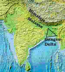
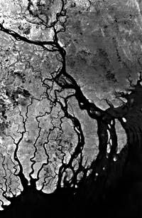 The Ganges-Brahmaputra- Meghna Delta Plain, the largest in the world, inhabited by a tenth of the population on our planet, is leading to a major catastrophe caused by deforestation, construction of dams, embankments, agrochemical, uncontrolled discharge of untreated municipal and industrial wastes etc. Many prohibited pollutants are directed to river waters.
 The Himalayan rivers contribute one-third of the global sediment transport to the world oceans (Millman et al., 1983). Since millions of years the Bengal basin received millions of flood that created this land to the present form. With the birth of the modern Himalayan Mountains about 35 million years ago the mighty rivers drained along paleoslopes and deposited about 16-18 kilometres of thick sediments in Bangladesh. Present relative plate motion between the Indian plate and the Asian plate is apparently in a north-east-south-west direction at a rate of convergence of between 5 and 6 cm per year, also plays an important role in channel migration, erosion, deposition and overflooding in Bangladesh.
Major changes in flow patterns of the main rivers are basically related to tectonic evolution of the sub-continent. In the past, the Ganges and Brahmaputra have changed their courses several times.
The Himalayan rivers contribute one-third of the global sediment transport to the world oceans (Millman et al., 1983). Since millions of years the Bengal basin received millions of flood that created this land to the present form. With the birth of the modern Himalayan Mountains about 35 million years ago the mighty rivers drained along paleoslopes and deposited about 16-18 kilometres of thick sediments in Bangladesh. Present relative plate motion between the Indian plate and the Asian plate is apparently in a north-east-south-west direction at a rate of convergence of between 5 and 6 cm per year, also plays an important role in channel migration, erosion, deposition and overflooding in Bangladesh.
Major changes in flow patterns of the main rivers are basically related to tectonic evolution of the sub-continent. In the past, the Ganges and Brahmaputra have changed their courses several times.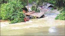 Environmentally unplanned embankments all over Bangladesh, India have created more harm rather than giving protection during flooding. It may be mentioned that after each flood record crop-yield was registered in Bangladesh.
From flood to scarcity of water: re-defining the water debate
A recent study found that scarcity not excess of monsoon floodwaters appeared to be the primary concern of the majority of livelihood groups. Scarcity of floodwaters is impacting on livelihood in multiple ways that include:
A need to re-think the prevalent paradigm in Bangladesh from how to cope with too much water in monsoon (i.e., flood) to how to cope with lack of water in future (Chadwick, M.; Soussan, J.G.; Alam, S.S.; Mallick, D., 1997).
Another devastating flood may follow: Experts
"We have to be vigilant," says the WFP Country Representative in Dhaka, Douglas Casson Coutts. "What we have seen so far is as bad as any floods in Bangladesh have been. But there may be worse to come, and we need to be ready," he says.
The New York-based UN Children's Fund (UNICEF ) says sewerage systems in cities including the Bangladesh capital, Dhaka, have collapsed. About 1.5 million people - including children - are camping in refugee shelters.
Among the diseases stalking an estimated 25 million people affected by the floods are an acute respiratory infection, diarrhea, watery dysentery, jaundice, typhoid and scabies.
World organizations stress that Bangladesh is exposed to epidemics because of filthy water. Reports say emergency medical teams from Bangladesh and neighboring India are treating thousands of people in Dhaka who fell ill after drinking contaminated water.
The July floods have ruined food stocks and, as WFP points out, removed sources of nutrition and income. A statement issued by the organization stresses that fish and poultry farms have been flooded. There is a distress sale of livestock as there is no fodder available for the animals.
The UN body stresses that it is concerned about food security in Bangladesh. "Even though people in Bangladesh are used to grappling with flood damage every year, they will need a lot of help this year in recovering their household stability and preparing for the next planting season," Coutts says. "The international community must not forget about the enormous problems here after the disaster images fade from the TV screen."
(Bangladesh Observer, August 5, 2004).New Flood, September 2004
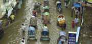 Only a couple of weeks since Dhakaites recovered from a prolonged flood, another rain-borne flood hit Dhaka on September 13. The three-day long heavy shower caused serious waterlogging in the city, yet again. For three days, life came to a virtual standstill. People were forced into self-imprisonment, business came to a halt, and acute crisis of drinking water made life unbearable. Waterlogging, once thought to be a problem only for a few low-lying areas in Dhaka, has suddenly threatened to become a regular event in the rainy season. Could this waterlogging have been avoided? What can we do to protect Dhaka from getting waterlogged in the future ?, (Daily Star, September 24, 2004).
 Dhaka-Narayanganj-Demra (DND) Embankment - Permanent Waterlogging
2.Floods
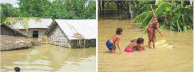
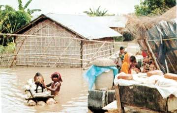
2.1. North East India
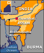 Massive flooding brought new death and disruption to northeast India yesterday and also threatened a national park famous for its rare one-horned rhinoceros population (July 14, 2004).
The 430-square-kilometre (266-square-mile) park east of Assam's principal city of Guwahati is home to the world's largest concentration of one-horned rhinoceros.
There are an estimated 1,600 rhinos at Kaziranga out of a total world population of some 2,300.
"Herds of elephants, deer, wild buffaloes and rhinos from the park are migrating to an adjoining hill for safety," another park official said.
Some 70 animals, including rhinos and wild buffaloes, were drowned by flooding in the sanctuary last year. Drinking water
The BBC's Subir Bhaumik, who is in the state, says the air force has been airlifting supplies of fresh drinking water.
"We will sleep in the open, we will do everything on the road but if we don't have drinking water, we will perish," one woman told him.
Bihar state has also been badly hit - the authorities say 225 people have died in heavy rains this month (BBC, July 23, 2004).
2. 2. Floods in the Mekong basin
Himachal Pradesh
Nepal
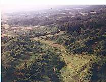 In Nepal, the authorities say more than 100 people are feared dead following torrential monsoon rain and landslides over the past two months.
The Nepalese Home Minister, Govinda Raj Joshi, said more than 100 people are missing as a result of the floods, and most of these are feared to have died.
In Nepal, the authorities say more than 100 people are feared dead following torrential monsoon rain and landslides over the past two months.
The Nepalese Home Minister, Govinda Raj Joshi, said more than 100 people are missing as a result of the floods, and most of these are feared to have died.
Thousands of others have been displaced, and hundreds of hectares of farm land has been washed away.
The damage caused by this year's monsoon rains has been more severe than in previous years.
Environmentalists say deforestation in hill areas is the one of main causes of flooding throughout the South Asia region.
Rainforest Destruction from Himalayas to Coastal Areas
2. 3. Bangladesh- 2004
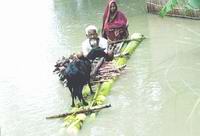
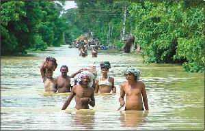
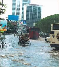
2.3.1. 20 million people in Bangladesh have been left homeless:
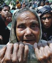 Residents of the Bangladeshi capital Dhaka are trying to build up defences against rising floodwaters which have already covered 40% of the city.
Nearly three-quarters of the country is under water, and more than 200 people are reported to have died.
Across the whole of South Asia, more than 550 people have been killed as a result of monsoon flooding since June.
Although the Ganges and Meghna rivers have begun to recede upstream in India, forecasts predict heavy rain to come.
At least 20 million people in Bangladesh have been left homeless.
Residents of the Bangladeshi capital Dhaka are trying to build up defences against rising floodwaters which have already covered 40% of the city.
Nearly three-quarters of the country is under water, and more than 200 people are reported to have died.
Across the whole of South Asia, more than 550 people have been killed as a result of monsoon flooding since June.
Although the Ganges and Meghna rivers have begun to recede upstream in India, forecasts predict heavy rain to come.
At least 20 million people in Bangladesh have been left homeless.
She tried to stay the last minute out in her shanty enduring all woes but left when one of her children drowned in floodwaters at the dead of night.
(BBC, 25 July, 2004)
We wonder whether Dhaka is the dirtiest, most mismanaged and polluted capital city of the world. It appears that there is no law and order, no discipline and decency in the public roads.. Dhaka is a city of melancholy contrast wherein a few people live and work in air-conditioned houses and offices, travel by expensive cars of latest model, hold meetings and seminars and have feast and festivals at luxurious hotels and majority of the people live in slums and pass their lives in absolutely poverty deprived of even basic civic amenities like water supply, sanitation and electricity...
The ordeal of a water-logged city
No alleviation measures in sight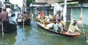 Why the city roads go under knee-deep water even after a moderate rainfall remains an annoying question in the minds of the citizens. The water-logging in the main thoroughfares disrupts normal life with vehicles and pedestrians getting stranded for hours. The already heightened traffic congestion is rendered intolerably worse.
The media has been crying hoarse in a bid to draw the attention of the city fathers to the problem but the latter's apathy only adds insult to the injury. The way water-logging has exacerbated in the city year after year would have provided sufficient ground for citizens' groups elsewhere to press public demands for an early solution to the problem or face condemnation. Unfortunately, no political party talks of the problem, they being distracted by high sounding political issues.
Why do city roads suffer from water-logging after a little rain? To quote some officials of the Dhaka Water Supply and Sewerage Authority, it was only slightly over 85 millimeters of rainfall on last Saturday, but that is not enough to flood the roads the way it did. So, what went wrong? The answer lies in the encroachment and filling up of the natural drainage sources like the numerous canals that crisscrossed the city once, and the moribund condition of the underground and surface drainage systems. While last year there was much ado about reclaiming some of those canals from the hands of the encroachers, the Dhaka City Corporation (DCC) suddenly stopped the drive.
The water-logging problem has to be addressed on both a short-term and long-term basis. What is imperative at the moment is to set up a taskforce during the rainy months whose job it will be to arrange for contingency pumping of water out to a safer zone and brick-soling the pot-holed roads so that transports can move unstuck on them. The authorities will also have to make the storm sewers operational through removing all materials that clog these outlets.
On the long-term side, we need to make the moribund canals within the city area and on its periphery operational. Secondly, the encroachments on the river banks must be removed so that the excess water can find its way into the larger rivers.
Unless the challenge is responded to on a national footing we have a serious problem lying in store for us in the shape of a more dysfunctional city (Editorial, Daily Star, September 25, 2006).
2.3.2. Mass migration to slums of Dhaka
Displaced streaming into city
 Ayesha Begum, 36, who abandoned her submerged home in Sirajganj, managed a tiny room at a flood shelter in Bashabo. She, along with her husband and their 8-year-old daughter Aklima, came to Dhaka a week ago and spent two nights at Kamalapur Railway Station.
"We have nowhere to go. We have finally come here after roaming many places and spent two nights without food or water," Ayesha said.
Desperate for a job, her farm worker husband Abul Kashem, 46, was out of the shelter and Ayesha does not know when he will be back. "He will grow mad if he does not find some food today. How can a child spend days without food," she asked.
Ayesha Begum, 36, who abandoned her submerged home in Sirajganj, managed a tiny room at a flood shelter in Bashabo. She, along with her husband and their 8-year-old daughter Aklima, came to Dhaka a week ago and spent two nights at Kamalapur Railway Station.
"We have nowhere to go. We have finally come here after roaming many places and spent two nights without food or water," Ayesha said.
Desperate for a job, her farm worker husband Abul Kashem, 46, was out of the shelter and Ayesha does not know when he will be back. "He will grow mad if he does not find some food today. How can a child spend days without food," she asked.
"If we stay in Dhaka, we will be able to find some baby food but there is nothing back at home."
Ayesha's is not a one-off story. Displaced people moved into the city because of the raging floodwaters that blighted two-thirds of Bangladesh.
Because of the floods, Dhaka has to provide shelters for new comers while the city is already overburdened with more than 13 million people. "Poor people have been coming to the city in search of jobs for long. Now the numbers will increase as they are driven by the deluge," a university student said.
The floodwaters left more than 30 million people homeless or cut off in 47 districts, while about five million people are affected in the capital.
The inflow of displaced people to the city is up. They are rushing to the capital like floodwaters. Most are living under flimsy shelters built with plastic sheeting on sidewalks and pavements.
(Daily Star, August 1, 2004)
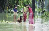 People in their swamped villages in Nilphamari, Gaibandha, Kurigram, Lalmonirhat, Rangpur, Bhola, Barisal, Bogra, Sherpur, Faridpur, Rajbari, Sirajganj, Sunamganj, Sylhet and Moulvi Bazar reeled under food, drinking water and medicine crisis.
 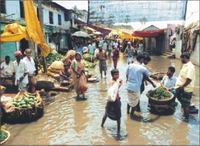 The flood situation in Bogra worsened because of heavy rains and rising waters in the Jamuna and Bangali rivers.
Reports of Sylhet correspondent say: The floods in badly-affected Sylhet remained unchanged with inundation of new areas in Jakiganj, Beanibazar and Fenchuganj upazilas and rivers flowing above the danger mark.
Abdul Momin drowned in a remote rain-fed water-body in Dharmapasha upazila in Sunamganj on Monday and a young man died in Chhatak upazila and two others, including a minor boy, in Jaintapur the same day.
The flood situation in Bogra worsened because of heavy rains and rising waters in the Jamuna and Bangali rivers.
Reports of Sylhet correspondent say: The floods in badly-affected Sylhet remained unchanged with inundation of new areas in Jakiganj, Beanibazar and Fenchuganj upazilas and rivers flowing above the danger mark.
Abdul Momin drowned in a remote rain-fed water-body in Dharmapasha upazila in Sunamganj on Monday and a young man died in Chhatak upazila and two others, including a minor boy, in Jaintapur the same day.
2.3.3. WATERBORNE DISEASES
"We have no choice but to take floodwater for the last 20 days. We are not getting water purifying tablets in the locality," said Solaiman of Keodala village (August 1, 2004).
She said, “The water of the tube-well was of that colour at the time of collection.”
“We do not bother whether the water is good, because we can hardly get any drinking water,” said Rahmat Ali at Begunbari Katherpool. He told New Age that of about 100 tube-wells in the village, only four still remain above the water level
(New Age, August 1, 2004).
WATERBORNE DISEASES Responsible pathogen
Route of exposure Mode of transmission
Cholera Vibrio cholerae bacteria l gastro-intestina
often waterborne
Botulism
Clostridium botulinum bacteria Clostridium botulinum bacteria
food/water borne; can grow in food
Typhoid
Salmonella typhi bacteria
gastro-intestinal
water/food borne
Hepatitis A Hepatitis A virus
gastro-intestinal
gastro-intestinal
Dysentery
Shigella dysenteriae bacteria or Entamoeba histolytica amoeba
gastro-intestinal
food/water
Cryptosporidiosis
Cryptosporidium parvum protozoa
gastro-intestinal
waterborne; resists chlorine
Polio
polioviruses
gastro-intestinal
exposure to untreated sewage; may also be waterborne
Giardia Giardia lamblia protozoa gastro-intestinal waterborne
Hospitals fill with diarrhoea patients:
Diarrhoea outbreak has taken a serious turn in the city's flood-hit areas and experts fear the worst will come when the floodwaters recede.
Sources at the International Centre for Diarrhoea Diseases Research, Bangladesh (ICDDR,B), popularly known as Mohakhali Cholera Hospital, said 475 patients, most of them children, were admitted to the centre yesterday. Only the previous day, the number was 441.
They said diarrhoea patients are increasing every day.The big risk is epidemics
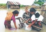 The victims of Bangladesh's floods are surviving for now, the death toll has been remarkably low, but every day their situation becomes more precarious.
"I think it will be dangerous if it continues for long because people will be suffering," said Mustafizur Rahman, deputy commissioner of Munshiganj.
"They have no shelter, their crops are damaged and there are health hazards. We are endeavouring to protect them but it is not sufficient. If it continues for long it will be very hard for us to protect them."
Snakebite incidents rise as flood water swells
Last week about 50 people, mostly women and children, were admitted to Dhaka Medical College Hospital with snakebites.
The victims were bitten at home and mostly during daytime.
The hospital records show, the patients came from Hazaribagh, Azimpur, Rampura, Badda, Kamalapur, Goran, Rajabazar, Mirpur, Banani and Gulshan in the city, and Kamrangirchar, Keraniganj, Savar and Tongi on the outskirts.
A large number of snakebite victims also came from Gazipur and Narayanganj.
Mehdi Hasan, a six-year-old boy of Manda in Badda, said he had been bitten by a large snake inside his bedroom and added that the serpent slipped away after biting his right foot. Mehdi was under observation at the DMCH paediatric ward.
“Snakebites kill a large number of people during monsoon in the country every year, but unfortunately, there were no adequate facilities for treating snakebite patients in government hospitals in the country, not even at the hospital,” said Professor FM Siddiqui of medicine at Dhaka Medical College.
Last month he treated two patients, who had been bitten by poisonous snakes, but could not save one of them. He had to borrow anti-snake venom from one of his colleagues as it was unavailable in the market.
He said snakebite incidences increase during flood because flood water reduces land area and flushes out snakes from underground dens.
The snakes while seeking shelter on higher grounds frequently encounter people, which results in snakebites.
Dr Anwar Ullah, a medical officer of Ward 3 at the DMCH, said most patients had been bitten by non-venomous snakes.
Some patients also come to hospital, taking injuries from sharp objects for snakebites, he added. “We discharge such patients after first aid and keep snakebite victims in hospital for 24 hours for observation.”
Doctors are facing difficulties to treat patients, bitten by venomous snakes, as antidotes are not available in the market.
An intern of the Ward 4 of the DMCH said last month one patient was referred to the hospital from the Mymensingh Medical College Hospital. He died because of delay in starting treatment in Mymensingh and in Dhaka.
Only the Chittagong Medical College Hospital is equipped with facilities for treating poisonous snakebites.
Professor M Abid Hossain, head of paediatrics, said it was impossible to prevent snakebite incidents during flood as people and snakes compete for shelter.
Health workers in flood affected areas should be trained to give first aid to snakebite patients and refer them to nearby hospitals. Tying tight ligatures proximal to the bite spots is not at all recommended, Abid said.
An estimated 10,000 people are bitten by snakes every year and the mortality rate is as high as 20 per cent.
There were 28 different species of venomous snakes including 12 species of sea snakes.
As public hospitals are not adequately equipped with logistics and trained manpower for managing life threatening venomous snakebites, people mostly rely on traditional healers
(New Age, 31 July, 2004).
1. Mosquitoes droning menacingly in Dhaka Bangladesh
2. Malaria strikes capital Dhaka Bangladesh
3. Dengue menace lurking in the wings
Official death toll 202
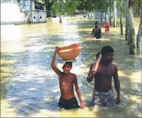 More than seven lakh people have been forced to take refuge in 1,752 makeshift flood shelters in the 35 districts while more others have been marooned or have taken shelter elsewhere.
The deluge completely eroded 5,630 kilometres of roads, partly damaged 21,844 kilometres of roads and destroyed 2,089 bridges and culverts.
The official statistics said the flood killed at least 4,000 cattle, destroyed standing crops on 7,27,697 acres of land and partly damaged yields on 1,165,790 acres.
More than seven lakh people have been forced to take refuge in 1,752 makeshift flood shelters in the 35 districts while more others have been marooned or have taken shelter elsewhere.
The deluge completely eroded 5,630 kilometres of roads, partly damaged 21,844 kilometres of roads and destroyed 2,089 bridges and culverts.
The official statistics said the flood killed at least 4,000 cattle, destroyed standing crops on 7,27,697 acres of land and partly damaged yields on 1,165,790 acres.
 Thousands are awaiting relief on Brahmaputra Flood Control Embankment and other high places while over five lakh families are still marooned in flood affected areas of Gaibandha.
They need cooked food and drinking water as most of them have no firewood and cooking utensils, many told this correspondent during a visit on Monday.
Thousands are awaiting relief on Brahmaputra Flood Control Embankment and other high places while over five lakh families are still marooned in flood affected areas of Gaibandha.
They need cooked food and drinking water as most of them have no firewood and cooking utensils, many told this correspondent during a visit on Monday.
"We are passing the daytime any how but sun set brings nightmare as we have no candle or lantern", said Nazly of Ghar Rahamtpur in Fulohari upazila, now on the Brahmaputra Flood Control Embankment.
"Where will we go? I looked on as the Brahmputra washed away my dwelling", said Hafizur of Daltipara village in Gaibandha Sadar upazila (Daily Star, 28 July, 2004)..
2. 3. 4. North East Bangladesh
Vast haor area is covered by crops threatened by regular floods
 The open water and the closed water bodies inclusive of haors, baors and beels are respectively of 40,47,000 ha and 3,51,000 ha totaling 43,98,000 ha that comprise 30 percent of the total surface area of Bangladesh. Haors (wetlands) are clustered in the north-east region and are large bowl-shaped flood plain depressions. The north-east region is one of the eight such distinct and defined units that hydrologically zone the entire country. Its area is estimated at 24,200 square kilometer i.e. 17.50 percent of the country's total land surface.The principal rivers of the region include the Surma and the Kushiyara which drain the eastern side of the region and, the Kangsha the western side while the rivers Kalni and Baulai drain the central basin.
Food Crisis
2. 3. 5. Flood in Southern Coastal Districts
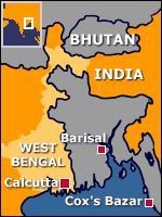 Fresh areas in Barisal, Jhalakathi and Patuakhali districts including parts of the district towns were flooded in the last two days as waters rolling down from the central districts can not recede due to a low in the Bay and the turbulent sea.
The floodwater continued to rise yesterday.
Meteorological Department officials said yesterday that the low could turn into a depression and cross over Orissa in India but may cause downpour in Bangladesh. The sea is very rough because of the low, they said.
Fresh areas in Barisal, Jhalakathi and Patuakhali districts including parts of the district towns were flooded in the last two days as waters rolling down from the central districts can not recede due to a low in the Bay and the turbulent sea.
The floodwater continued to rise yesterday.
Meteorological Department officials said yesterday that the low could turn into a depression and cross over Orissa in India but may cause downpour in Bangladesh. The sea is very rough because of the low, they said.
2. 3. 6. Trading On Human Misery
Micro-credit and NGOs
New Age has learnt that the number of the local and the national level NGOs are continuing to press, either directly or indirectly, the flood-hit micro-credit borrowers to pay back their loans.
Rahima Begum, a flood victim of Kadamtala in the city, said she had paid her BRAC loan instalment during the flood as she felt an indirect pressure to repay loan. "If I fail, I will have to lose my eligibility for receiving any loan in future," she said.
Flood victims Renu Begum of Mugda and Nazma Begum of Madinabagh Lane said although they tried their best to remain regular in paying instalments of the ASA, they failed for two weeks.
"The field officer did not put pressure on me but I will pay two instalments together this week as my failure to repay loans will be considered as non-cooperation," said Renu Begum, who took shelter at Haider Ali High School at East Manda.
Meanwhile, the Bangladesh Sangbad Sangstha, a state-owned news agency, reported that the loan officers of the NGOs, including the Bangladesh Rural
Development Board, have been moving door to door of the marooned borrowers by boats to realise the instalments that have put extra burden on the flood victims.
Besides, a number of the NGO field workers, preferring not to be named, said their salaries had been held up for failure to realise the instalments of micro-credit. (New Age, August 15, 2004).
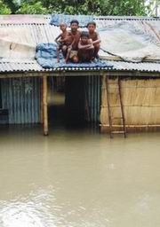 Ten kilograms of rice, enough to last a family for just a few days. It is a start but it is not much.
"It is not possible to survive on this food. I can only manage two or three days with this rice," said one man.
"It's not much but I have nothing else," said one woman. "At least now I can cook and eat."
Across the flood-affected regions hundreds of thousands, perhaps millions of people are moving to higher groundFarmers face harassment in getting loan
Village money lenders active, exact high interest
UN sees major humanitarian crisis after flood
The World Food Programme release said heavy flood in April destroyed substantial parts of the rice crop and another flood in July wiped out food stocks of many households. The next rice harvest is expected in 10 months, it said.
The UN agency expressed its concern about the forthcoming high tide in the Bay of Bengal, which would considerably limit the outflow of flood water into the sea.
With the high tide expected in early August, a serious humanitarian crisis could break out in a matter of weeks, it said.
The agency was also concerned about the current food shortage and its implications for the future.
The disease control room of the health directorate said 41 people died and 72,089 people have suffered from diarrhoea across the country in July till Saturday.
One died of diarrhoea and 1,513 were admitted to hospital across the country with complaints of the water-borne disease in 24 hours ending at 6:00pm Saturday, the control room said.
The death figure from flooding till Saturday stands at 205 as flood water continued to inundate fresh areas. The flood has so far affected 21 million people, according to an official statement.
Road communications between Sirajganj and the northern region was snapped as a portion of a bailey bridge on the Sirajganj-Bogra Highway at Kamarkhand upazila was washed away, the United News of Bangladesh reported.
Road communications between the south and the capital is also under threat as the Dhaka-Aricha Highway went under flood water at different points, the agency reported.
The flood situation in 17 districts continued worsening as rain-fed rivers remained in spate. The flood has affected 48 districts till Saturday, the flood forecasting centre said
(New Age,25 July, 2004)
" WE WILL STARVE RATHER THAN TAKING SUCH RELIEF”
Not Looking up to Governmentovt or NGOs
At Kulaura in Maulvibazar people from seven unions have joined hands to repair a damaged embankment. College and school students are moving sacks of freshly dug out earth from one corner of the breached embankment to another so as to reinforce it along the weak stretches.
Seeds, fertilizers for Rajbari flood victims sold in blackmarket
2. 4. Causes of Devastating Floods
29 flood-protection dams endangered
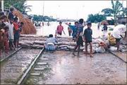 Two major cities, including the capital, and nineteen other towns are threatened by floodwater as 29 flood protection embankments built around those urban centres are reportedly either vulnerable to breaches or endangered for lack of maintenance
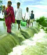 Structural interventions have aggravated the flood situation. Roads and embankments have been built without considering the nature of the water flow creating new flood prone areas. The major problem lies there. New areas are coming under floods and people of these regions are not used to it and therefore do not know how to cope with it. A number of measures in the past like the recommendation of the Krugg Mission in 1956 following the massive floods of 1954 have done more damage to the landscape and brought new areas under flooding. The Flood Action Plan (FAP) that followed the massive floods of 1988 was abandoned as it did not take the environment, adequately, into consideration. Besides, it was considered to expensive for a poor country like Bangladesh.
2m to remain marooned at DND for 2 weeks
2. Let Rivers be Returned to Rivers
3. The Brahmaputra's Changing River Ecology
4. The big melt has begunClogged up canals keep Dhaka city waterlogged
Dutch water engineering
KUMAR RIVER - THE RIVER OF SORROW
The problem of development
To be modern, people started developing communications systems like roads that is blocking the water, and s creating quite negative consequences for our ecosystem, and they're also creating different kinds of embankment and they're planning to divert the river waters and the river systems.
So a lot of this attempt at development has been about man trying to force himself on Nature and what you're telling me is that the traditional Bengali way has been to go with the flow and that has worked better.
If you compare the history of the old cyclones and flood waters, you'll see the misery has increased (into more modern times). The misery has increased with this kind of 'engineering' solution to water.Himalayan Snows
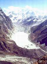 Environmentalists are warning that the melting of glaciers in the Himalayas could spell disaster for millions of people living in the region.
They claim the situation is not being adequately monitored; the last major studies having been done in the 1990s.
Swelling glacial lakes would increase the risk of catastrophic flooding.
Environmentalists are warning that the melting of glaciers in the Himalayas could spell disaster for millions of people living in the region.
They claim the situation is not being adequately monitored; the last major studies having been done in the 1990s.
Swelling glacial lakes would increase the risk of catastrophic flooding. This is a lake that should not exist. It is 6,000 metres above sea level, a kilometre long and 100 metres deep.
Twenty-five years ago it was a glacier. United Nations Environment Programme (Unep), shows anecdotal evidence that the Himalayas are changing. At an altitude of over 4,000m, the crew found a vast glacier lake, which according to their maps, had not been there a few decades before. But since then, temperatures in what is one of the world's largest ice fields have risen year after year. The lake is held in place by a wall of frozen rock known as its terminal moraine.
The ice that binds it together is melting and it is inevitable that sooner or later this natural dam will burst, releasing a massive wall of water down the valley.
This is a lake that should not exist. It is 6,000 metres above sea level, a kilometre long and 100 metres deep.
Twenty-five years ago it was a glacier. United Nations Environment Programme (Unep), shows anecdotal evidence that the Himalayas are changing. At an altitude of over 4,000m, the crew found a vast glacier lake, which according to their maps, had not been there a few decades before. But since then, temperatures in what is one of the world's largest ice fields have risen year after year. The lake is held in place by a wall of frozen rock known as its terminal moraine.
The ice that binds it together is melting and it is inevitable that sooner or later this natural dam will burst, releasing a massive wall of water down the valley.
There had, though, been a glacier. In the long term, the glaciers could disappear altogether, causing several rivers to shrink and threatening the survival of those who depend on them.UN conference (2003) in Milan on climate change reports:
Global warming is killing about 150,000 people a year, mostly in deprived and tropical areas, and the toll could rise dramatically if efforts are not made to combat climate change, the World Health Organisation (WHO) warned yesterday.
The United Nations agency said the health of millions of people was under threat as a consequence of rising temperatures and uncertain weather patterns, which many scientists claim are caused by greenhouse gas emissions.
The report said that even a rise of a few degrees in average annual temperatures could expose millions more people to the threat from malaria. This would be by both extending the malaria season in countries, where it is already endemic, and also by allowing the malaria mosquito to live in countries where, at present, it cannot survive, such as Europe. Other diseases spread by mosquitoes, such as dengue fever, could also increase.
Hotter and wetter conditions are also likely to increase the spread of diarrhoeal disease, which is particularly dangerous to children. And people living in deprived conditions who cannot afford proper refrigeration are more likely to eat food tainted with increased bacterial contamination, caused by higher temperatures. Countries which are heavily dependent on a predictable monsoon season for the cultivation of rice crops - such as India, Bangladesh and Burma - are more likely to suffer increases in malnutrition if the changes affect the reliability of the rainy season (Independent UK, 12 December, 2003).
Since 1862, more than 27 major floods have plagued the Napa Valley, resulting in significant loss of life and damage to
property. Among the most damaging was the flood of 1986 which caused more than $140 million in damage and led to the evacuation of 7,000 residents. The 1995
flood damaged an estimated 227.
Dhaka: Ecological Disaster
According to the Conservation Act, no-one has the right to develop wetlands, flood-flow zones or catchments. But developers and landowners have illegally occupied and filled up the areas.
Aerial photos show how water bodies are narrowing down because of land filling.
“The government also violates laws. The government plans to develop the city's last remaining water body in Hatirjheel area, spelling a disaster for the city," said Professor Nurul Hasan, chairman of Urban Planning Department at Bangladesh University of Engineering and Technology.
Experts said the areas could consume a huge volume of floodwaters and protect many areas from flooding. Moreover, the city had canals, 26 water-reservoirs, hundreds of small and large ponds and marshlands which preserved overflowing water while the canals sent it into different channels.
"If we had saved the water bodies, canals and ponds, it could have consumed a third of floodwater," said Selim Bhuiyan, executive engineer of the Flood Forecasting and Warning Centre of the Water Development Board (WDB).
A 1992 survey conducted by Flood Action Plan (FAP) under WDB, the area of Dhaka is 118.62 square kilometres, while it has about 736 hectares of water bodies that are only 6 percent of the total area.
"The flood-prone and densely populated city requires 25 percent wetland and water bodies for flood control, breathing space and sustainable habitats of flora and fauna," Nurul Hasan said.
Last year, a developer engaged more than 100 dredgers for dumping millions of cubic metres of earth in the large wetland, Ashulia, which is under the flood action plan-zone 8A. It planned to create 35,000 plots on 6,000 bighas.
Apart from this project, the developer has grabbed more than 73 acres of government land in Ashulia.
Rajuk filed a case under clauses 5 and 8 of the Wetland Conservation Act against the developer with Savar Police Station. The developer was accused of illegally occupying wetland in Ashulia and filling it up without an official clearance
The low-lying areas near Rampura towards the Balu river, which is now called Aftabnagar under the flood action plan zone 8B, have also been grabbed. "It has made the drainage system in Dhaka vulnerable. Now it will be a serious barrier to the recession of floodwaters," a WDB official said.
The government planned to impose regulations on real estate developers to control the trend of filling up low-lying lands. It was supposed to formulate a separate policy for regulating the unplanned growth of the high-rise buildings. The housing and public works ministry last year initiated the plan, which is now shelved.
Housing and Public Works Minister Mirza Abbas said the Wetland Protection Act would be strictly enforced from now on to ensure environmental balance and flooding.
The ministry will demarcate 'all flood flow zones' around the city on the basis of the Dhaka Master Plan and aerial photos and make a public announcement soon, giving clear guidelines for real estate development
(Sultana Rahman, August 2, 2004).
Unplanned urbanisation
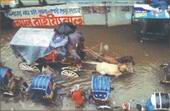 Unplanned urbanisation and inadequate drainage system have made the city a helpless victim of flooding due to the three-day downpour, disrupting the lives of millions of city dwellers.
Urban experts blamed the indifference of the authorities concerned, especially Rajdhani Unnayan Kartripakhya, for failure to stop the unabated filling up of water bodies and low-lying areas in and around the city, and for giving approval to high-rise buildings without considering the drainage and sewerage infrastructure.
Besides, the inadequate and dilapidated drainage network of the Dhaka Water Supply and Sewerage Authority is also blamed for the persistent water-logging during monsoon.
Unplanned urbanisation and inadequate drainage system have made the city a helpless victim of flooding due to the three-day downpour, disrupting the lives of millions of city dwellers.
Urban experts blamed the indifference of the authorities concerned, especially Rajdhani Unnayan Kartripakhya, for failure to stop the unabated filling up of water bodies and low-lying areas in and around the city, and for giving approval to high-rise buildings without considering the drainage and sewerage infrastructure.
Besides, the inadequate and dilapidated drainage network of the Dhaka Water Supply and Sewerage Authority is also blamed for the persistent water-logging during monsoon.Modhumoti Model Town: Lawful breach of the law
 A realty company has for long been filling up a vast area in the flood-flow zone near Amin Bazar to develop a housing estate in defiance of the city's master plan and the city planners, with an unexpected backing of the country's higher courts.
The developer, Metromakers and Developers Limited, is filling 350 acres of swampy land in two mouzas, Bilmalia and Baliarpur, at the city outskirts to build a township christened Modhumoti Model Town.
A realty company has for long been filling up a vast area in the flood-flow zone near Amin Bazar to develop a housing estate in defiance of the city's master plan and the city planners, with an unexpected backing of the country's higher courts.
The developer, Metromakers and Developers Limited, is filling 350 acres of swampy land in two mouzas, Bilmalia and Baliarpur, at the city outskirts to build a township christened Modhumoti Model Town.
Flood control measures must not alter natural system
Back to Content
3. Desertification and Drought
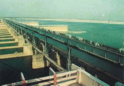 This unilateral withdrawal of river flows from the Ganges since 1975 through the construction of the Farakka Barrage by India has threatened the ecological balance in the south-western part of Bangladesh, and will turn this entire area into arid land if the river flows are not re-established. Around 123 miles of four rivers, along with the Ganges, have become non-navigable due to the formation of shoals, and soil degradation has affected agriculture.
In agricultural context drought affects the rice
production most. Due to drought severity, crop loss ranges between 20->60 per cent for T. Aman and
other rice varieties (Iqbal, 2000). It is one of the most insidious causes of human misery.
4. WARN OF A GREAT HIMALAYAN QUAKE
 About 225 million years ago, India was a large island still situated off the Australian coast, and a vast ocean (called Tethys Sea) separated India from the Asian continent. When Pangaea broke apart about 200 million years ago, India began to forge northward. By studying the history -- and ultimately the closing-- of the Tethys, scientists have reconstructed India's northward journey.
  About 80 million years ago, India was located roughly 6,400 km south of the Asian continent, moving northward at a rate of about 9 m a century. When India rammed into Asia about 40 to 50 million years ago, its northward advance slowed by about half. The collision and associated decrease in the rate of plate movement are interpreted to mark the beginning of the rapid uplift of the Himalayas.
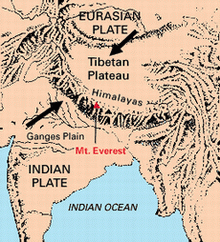 The India Plate is part of the great Indo-Australian Plate, which underlies the Indian Ocean and Bay of Bengal, and is drifting northeast at an average of 5 cm/yr (2 in/yr) (or 15 m (50 ft) per 300 years), relative to the Burma Plate. The Burma Plate carries the Nicobar and Andaman Islands and northern Sumatra, and is pushed by the Sunda Plate to its east. Both the Burma and Sunda Plates are considered portions of the great Eurasian Plate.
The tectonic activity that results as these plates scrape against each other led to the creation of the Sunda Arc. The 2004 Indian Ocean Earthquake was an undersea megathrust earthquake of moment magnitude 9.0 that struck the Indian Ocean off the western coast of northern Sumatra, Indonesia on December 26, 2004 at 00:58:49 UTC (07:58:49 local time in Jakarta and Bangkok). It was the largest earthquake on Earth since the 9.2-magnitude Good Friday Earthquake which struck Alaska, USA, on March 27, 1964, and the fourth largest since 1900. Tens of thousands were killed by the resulting tsunamis, which were as high as 15 m and struck between 15 minutes and 3 hours after the quake, causing one of the most cataclysmic disasters in modern history.
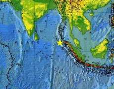 The hypocenter was at 3.298°N, 95.779°E, some 160 km (100 mi) west of Sumatra, at a depth of 10 km (6.2 mi) underwater, within the "Ring of Fire" zone of frequent earthquakes. The quake itself (apart from the tsunamis) was felt as far away as Bangladesh, India, Malaysia, Myanmar, Singapore, Thailand and the Maldives.
The earthquake was unusually large in geographical extent. An estimated 1,200 km (740 mi) of faultline slipped 15 m (50 ft) along the subduction zone where the India Plate dives under the Burma Plate. This formed a shock wave in the Indian Ocean, creating tsunamis that traveled at up to 800 km/h (500 mi/h) (USGS, 2004).
Traditional lifestyle saved dwindling aboriginal population in Andaman
 Major earthquakes occurring along subduction zones are especially hazardous, because they can trigger tsunamis (from the Japanese word tsunami meaning "harbor wave") and pose a potential danger to coastal communities and islands.
Tsunamis are often mistakenly called "tidal waves" when, in fact, they have nothing to do with tidal action. Rather, tsunamis are seismic sea waves caused by earthquakes, submarine landslides, and, infrequently, by eruptions of island volcanoes. During a major earthquake, the seafloor can move by several meters and an enormous amount of water is suddenly set into motion, sloshing back and forth for several hours. The result is a series of waves that race across the ocean at speeds of more than 800 km per hour, comparable to those of commercial jetliners.
The energy and momentum of these transoceanic waves can take them thousands of kilometers from their origin before slamming into far-distant islands or coastal areas. The 1883 eruption of Krakatau Volcano, located in the Sunda Straits between the islands of Sumatra and Java, Indonesia, provides an excellent example of an eruption-caused tsunami. A series of tsunamis washed away 165 coastal villages on Java and Sumatra, killing 36,000 people. The larger tsunamis were recorded by tide gauges as far away as the southern coast of the Arabian Peninsula-more than 7,000 km from Krakatau!Collision between the Indian and Eurasian plates
 The collision between the Indian and Eurasian plates has pushed up the Himalayas and the Tibetan Plateau.The Himalayan mountain range dramatically demonstrates one of the most visible and spectacular consequences of plate tectonics. When two continents meet head-on, neither is subducted because the continental rocks are relatively light and, like two colliding icebergs, resist downward motion. Instead, the crust tends to buckle and be pushed upward or sideways. The collision of India into Asia 50 million years ago caused the Eurasian Plate to crumple up and override the Indian Plate. After the collision, the slow continuous convergence of the two plates over millions of years pushed up the Himalayas and the Tibetan Plateau to their present heights. Most of this growth occurred during the past 10 million years. The Himalayas, towering as high as 8,854 m above sea level, form the highest continental mountains in the world. Moreover, the neighboring Tibetan Plateau, at an average elevation of about 4,600 m, is higher than all the peaks in the Alps except for Mont Blanc and Monte Rosa, and is well above the summits of most mountains in the United States
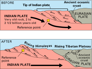
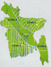 As Bangladesh is located close to the boundary of two active plates (Indian plate in the west and Eurasian plate in the east and north) the country has always been under threat of an earthquake that might be so catastrophic it will kill people in less than a minute. With the frequency of earthquakes on the increase, it is natural for people to be scared as experts consider them to be advance warning of what lies ahead. And with tremors in the Chittagong region increasing in frequency, experts believe we can expect a major one any day.
A tremor with intensity of 5. 1. on the Richter scale on July 22, 1999, left at least six people killed in the country's southeastern Maheshkhali (Chittagong district).
Date
Name of Earthquake Magnitude (Richter)
10 January, 1869 Cachar Earthquake 7.5
14 July, 1885
Bengal Earthquake
7.0
12 June, 1897 Great Indian Earthquake 8.7
8 July, 1918 Srimongal Earthquake 7.3
2 July, 1930 Dhuri Earthquake 7.1
15 January, 1934 Bihar-Nepal Earthquake 7.0
15 August Assam Earthquake 8.5
Tectonic block
Maximum Magnitude
of
Earthquake (Richter)
1. Bogra fault zone
7.0
2. Tripura fault zonr
7.0
3. Sub Dauki fault zone
7.3
4. Shillong Plateau
7.0
5. Assam fault zone
8.5
According to the researchers, although the major earthquakes that have occurred along the Himalayas since 1800 differed in dimensions, less than half of the Himalaya has ruptured in that period. When they divided the central Himalaya into 10 regions, with lengths roughly corresponding to those of great Himalayan ruptures (~220 km), they found six of these regions currently have a slip potential of at least 4m - equivalent to the slip inferred for the 1934 earthquake.
This implies that each of these regions now stores the strain necessary for such an earthquake. Moreover, the historic record has no great earthquake throughout most of the Himalaya since 1700, suggesting that the slip potential may exceed 6 m in some places. Fund shortage hinders activities of Earthquake Research Centre
EERC sources said acute fund crisis from the very beginning of its inception in late 1999 has virtually stopped its activities and that the center has failed to achieve the expected progress. Because of fund constraints, the center also could not conduct different types of academic and research works.
An institute under the Department of Civil Engineering of Chittagong University of Engineering and Technology (CUET), EERC plans to innovate appropriate but financially affordable technologies and methods on how to build earthquake proof concrete structures, easy determination of the intensity and magnitude of tremors and strengthening of earthen houses in rural areas by using low cost materials.
Some of the important research works now going on in the center include earthquake vulnerability study on the concrete structures of hospitals, educational institutions, residential buildings, liquefaction potentials and also lifeline structures like electricity, gas, water supply systems in Chittagong city areas.
Intensive studies are also going on under EERC to find out sustainability of concrete hollow blocks to increase the earthquake resistance, standardization of mild steel (as building materials) to prevent earthquake, increase the properties of cement manufactured by factories in the country, seismic design of masonry buildings and installation of earthquake intensity measuring fields.
Dr. Alam expressed his deep disappointment while stating that no significant step has been taken by the authorities concerned so far to the 9-point proposal submitted by EERC two years ago to the Disaster Management Board under the Ministry of Relief and Disaster Management for pre and post earthquake management.
He cautioned that a "strike by an earthquake measuring nearly 7 on the Richter Scale may led to heavy damage of human lives and properties in the densely populated metropolis in the country due to lack of awareness and necessary preparations".
In this context, he said it is not a matter to be resolved overnight but a well organized and practical plan which is needed to face such unpredictable natural catastrophe and also keeping in mind that time is running out fast as Bangladesh is located in one of the most earthquake vulnerable zone in the world (Bangladesh Observer, 4 August, 2004). The major faults and lineaments of Dhaka city
Dhaka ill prepared for quake disaster
Experts say Bangladesh is seismically active. The occurrences of earthquakes of an average magnitude of 5 in the Richter scale are quite frequent, especially in the eastern region.
According to them, micro-seismic data indicate that at least four earthquake source-points exist in and around the capital. They identify the western part of the city from Mirpur-Kalyanpur to Pagla along the Buriganga River and the eastern part from Uttar Khan-Badda to Demra along the Balu River as the two most high-risk zones.
The rate of strain accumulation is also high in the city's subsoil, which in case of a release may cause a tremor of an intensity of 6.8 in the Richter scale, experts say. The shallow subsurface of the city is also characterised by a number of faults.
Luckily, Dhaka has not experienced any moderate to large earthquakes in the recent past. Yet the earthquake on December 19, 2001 of a magnitude of 4.5 and a focal depth of 10km located very close to the city is a certain indication of its vulnerability (Daily Star, December 28, 2004).
One-third of capital (Dhaka) 'most vulnerable' to tremor
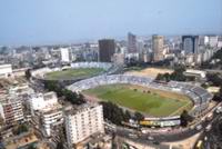 A recent research has found that about one-third area of the Dhaka city is "most vulnerable" to earthquake, and high-rise buildings, especially those between 9 and 14 storeys in height, will not be able to withstand a mid-level earthquake because of the city's typical soil characteristics.
Even 5-8 storey buildings will be vulnerable in some areas, including Bashundhara, low-lying parts of Rampura, Rupnagar to Duaripara in Mirpur, and Gabtoli to Rayerbazar embankment areas, because these areas have been recently filled with clay and silty materials.
A recent research has found that about one-third area of the Dhaka city is "most vulnerable" to earthquake, and high-rise buildings, especially those between 9 and 14 storeys in height, will not be able to withstand a mid-level earthquake because of the city's typical soil characteristics.
Even 5-8 storey buildings will be vulnerable in some areas, including Bashundhara, low-lying parts of Rampura, Rupnagar to Duaripara in Mirpur, and Gabtoli to Rayerbazar embankment areas, because these areas have been recently filled with clay and silty materials. Country more vulnerable to quake than tsunami
Tsunami may have caused untold ecological disaster
Earthquake jolts Chittagong
 Thousands of panicked residents came out of their houses after an earthquake measuring 4.8 in the Richkter scale jolted the Chittagong city Thursday afternoon. Seismic observatory officials said the earthquake with its epicentre 146 kilometres away from the port city lasted for 16 seconds from 5-41-18 seconds.
The police said no casualty was reported nor was any news of major damage of property received. Some old buildings at different places in the city developed cracks, the police said (New Age, Staff Correspondent, Chittagong, July 22, 2005) .
Thousands of panicked residents came out of their houses after an earthquake measuring 4.8 in the Richkter scale jolted the Chittagong city Thursday afternoon. Seismic observatory officials said the earthquake with its epicentre 146 kilometres away from the port city lasted for 16 seconds from 5-41-18 seconds.
The police said no casualty was reported nor was any news of major damage of property received. Some old buildings at different places in the city developed cracks, the police said (New Age, Staff Correspondent, Chittagong, July 22, 2005) . 90 per cent bldgs vulnerable to earth quake, NE Bangladesh (Syleht), Zone 1
Bangladesh susceptible to earthquakes
If Bangladesh is a fertile land where crops grow rather naturally then Dhaka city is the lushest land to grow urban infrastructures which often seem like developing rather ‘naturally’. And the result is the creation of a massive concrete jungle which is often referred as the ‘vertical slum’. And what will happen if earthquake hits this city?
According to RAJUK, about 90 per cent buildings of Dhaka city are vulnerable to earthquakes measuring above 7 on the Richter scale and 50 per cent of the buildings will be destroyed if an earthquake happens to be above six and all the building will be destroyed if an earthquake measures above 8 on the Richter scale. Besides, a study conducted in the eight wards of the capital in 2004 has revealed that most of the city’s 8-12 storey buildings (over 24,000 in number) could collapse in the event of an earthquake that is smaller in magnitude to the one that hit Pakistan. Crammed with more than 10 million people and packed with skyscrapers, the actual damage to Dhaka might exceed all studies and estimates, leading to a death-toll, experts say, which could be well over 100,000. And according to a study this number of deaths and injuries will have such an impact on emergency relief and healthcare infrastructure that Dhaka will not be able to function as the capital of Bangladesh.
The reasons for Dhaka being such vulnerable to earthquake destruction include high population density, construction lacking earthquake-resistant design, absence of legal enforcement of building code and its seismic design provisions, possibility of fire outbreaks due to rupture of gas pipelines or electric short-circuit during an earthquake and inadequate fire fighting facilities, inadequate road width and space between buildings preventing rescue operations and firefighting vehicles to reach certain areas and so on.
It’s like living on a time bomb. But concerned authorities must raise their level of awareness about the situation and precautionary measures must be taken in time to minimise the impact if and when such disaster strikes (God forbid!). There are some singular steps that an individual can undertake to stay safe. These include: if someone is on the ground floor and can get out very quickly (5-10 seconds), it is advised to rush outside to an open space away from buildings or electric posts. If that can’t be done, then it is advised that one must take shelter at selected places inside buildings which are relatively stronger against earthquakes such as near strong columns or near closely spaced walls in both directions. To avoid any casualty it is suggested to get under a table so that one is not hurt by falling objects from above, staying away from outer verandah, balconies, cantilever projections, outer walls, mirrors and doors (Source: New Age, September 26, 2006).Bangladesh runs high earthquake risk
The observatory at Bangladesh University of Engineering and Technology (Buet) recorded 86 tremors of over 4 magnitude during January 2006-May 2009. Another four earthquakes took place with magnitude of over 5 during the period.
The meteorological department detected at least 90 earthquakes taking place in the country between May 2007 and July 2008, nine of them above five on the Richter scale and epicentres of 95 percent being within a 600 kilometre radius of Dhaka city.
Experts say it is these minor tremors that indicate the possibility of much more powerful earthquakes hitting the country.
According to a seismic zoning map prepared by the Buet, 43 percent areas in Bangladesh are rated high risk, 41 percent moderate and 16 percent low, said Prof Mehdi Ahmed Ansary.
The map, which is being drawn up under the supervision of Prof Ansary with funding provided by the science and information and communications technology ministry, divides the country into three earthquake vulnerability zones.
Panchagarh, Rangpur, Gaibandha, Kurigram, Jamalpur, Sherpur, Mymensingh, Netrakona, Sunamganj, Kishoreganj, Moulvibazar, Sylhet, Habiganj and Brahmanbaria are placed in the highest risk zone. Parts of Thakurgaon, Sirajganj, Tangail, Rangamati, Khagrachhari and Cox's Bazar also fall into the category, said Prof Ansary.
Zone-2 includes Rajshahi, Natore, Magura, Meherpur, Comilla, Brahmanbaria, Feni and Dhaka while zone-3 is made up of all the islands, Barisal and Patuakhali.
The current zoning map has, however, not been included in the Bangladesh National Building Code (BNBC), which needs to be urgently updated, pointed out Ansary, who is also vice-president of the Bangladesh Earthquake Society.
In the zoning map of 1993, which was included in the BNBC, 26 percent of the country was high risk, 38 percent moderate and 36 percent low in terms of earthquake vulnerability.
ASM Maksud Kamal, an expert on earthquake and tsunami preparedness, said four sources of earthquake in the Bay of Bengal are active and can generate tsunami.
He said one of the sources generated an earthquake of 7.8 magnitude in 1762 which generated Fiche, waves caused by earthquakes in rivers and other closed water bodies, and around 100 people were killed in boat capsizes at that time in the Buriganga.
Kamal said all the four sources in the Bay called F1, F2, F3 and F4 have a capability of generating earthquakes of over 7 magnitude creating tsunami which will affect Bangladesh.
In that case the sea level will rise by 4-5 metres at Nijhum Dwip. The water level will rise 2-3 metres at the Sundarbans, Cox's Bazar and the estuary of the Meghna.
Kamal said seven major earthquakes struck Bangladesh during the last 150 years and only two had the epicentre within the country.
The Srimangal earthquake on July 8, 1918 was recorded at 7.6 on the Richter scale and its epicentre was in Balisera valley near Srimangal. Although there was damage, the intensity rapidly decreased due to the shallow focal depth and only minor effects were felt in Dhaka, he said.
The Bengal earthquake of July 14, 1885 caused considerable damage in the Sirajganj-Bogra region and perhaps more severe destruction in Jamalpur-Sherpur-Mymensingh region. The magnitude of the earthquake was more than 7.0 on the Richter scale and the epicentre was at Manikganj, he added.
During the 1762 earthquake in Chittagong-Arakan coast the magnitude was 7.6 but the exact epicentre remained unclear.
The great Indian earthquake of June 12, 1897 that had a magnitude of 8.7 with the epicentre in the central part of the Shillong plateau was recalled as one of the world's worst.
Based on the epicentres of earlier earthquakes, Dhaka has crossed 130 years, Chittagong has crossed 250 years and Sylhet about 100 years, which now raises the prospect of a major earthquake striking Bangladesh, said Kamal.
He observed that fault zones like Dauki fault zone, Shahjibazar fault zone and Tripura to Assam fault zone are very active and have been generating energy for quite a long time but as no earthquake occurred in those areas, it is a matter of time before the big one strikes.
Prof Ansary said eight fault zones are active in Bangladesh. They are Bogra fault zone, Tanore fault zone in Rajshahi, Tripura fault zone, Sitakunda-Teknaf fault zone, Dauki fault zone (Haluaghat Fault), Dhubri fault zone, Chittagong fault zone, Shahjibazar fault zone (sub-Dauki fault) and Rangamati fault zone (Borcal).
He said any minor earthquake might be due to the activity in the local small fault zones, thus increasing the chances of a major jolt happening. Besides, Ansary felt a strong earthquake could occur in the plate boundaries as the 100-year alarm bells have passed.
Bangladesh is close to the meeting point of the Indian, Eurasian and Burma (Myanmar) plates. The movement of Indian and Eurasian plates has been locked at the foot of the Himalayas for many years, storing strain energy, he said.
When the lock is released it will let out the strain energy causing major earthquakes that will affect Bangladesh, northeast part of India and Myanmar, Ansary explained.
Three strong earthquakes were recorded from the Indian-Eurasian plate, which jolted Bangladesh within 150 years, said Ansary.
Due to the Indian and Eurasian and Myanmar plates, the Bihar-Nepal earthquake took place in 1934 and it was felt as far away as Dinajpur and Rangpur, he said.
The Assam earthquake on August 15, 1950 had a magnitude of 8.6 on the Richter scale. The tremor was felt throughout Bangladesh but miraculously no damage was reported anywhere.
But the Mandelay earthquake that struck in 1858 with a magnitude of 7.9 did affected Chittagong division, he added (H. Alam, August 12, 2009).
5. TROPICAL CYCLONE
 A cylone in the Bay of Bengal need not start powerful than tropical storm elsewhere but the triangular shape of the Bay concentrates the force of the storm as it moves north and northeastward out of Indian Ocean. Of all the developing nation affilated by coastal storms, Bangladesh is the worst affected and posseses least preparedness to cope with such disaster. In industrial countries the same cylonic storm may cause deaths about 10, whereas in Bangladesh it will cause hundreds of thousands and turning the landscape into a mournful lake of floating corpses of human and animals desperate survivors.
There are no scientific and research oriented studies on morphological and gelogical changes in the cyclone-prone reigons of Bangladesh. A rapid land accreation along with forestation is an important aspect of economy and cyclone protection. Bangladesh needs coastal resource management in the light of poverty elimination programme, eclogical structural plan, cyclone preparedness, risk assesment, scietific studies on the effects of coastal storms, emergency programme (national and international) to fight against coastal disaster, protect water supply etc.
Situated at the head of the Bay of Bengal, most of Bangladesh is a delta formed by the convergence of three great rivers – the Ganges, the Brahmaputra and the Meghna. Eighty percent of Bangladesh is less than 1.5 metres above sea level and every year during the monsoon season the rivers flood half the country to a depth of 30 cm. The floods, which last for several months, have the environmental benefit of bringing fertile silt, but cause great disruption. Yet these annual floods are insignificant compared to the really disastrous floods caused by tropical cyclones.
 In 1970 a tropical cyclone and tidal surge killed more than 450,000 people. A repeat of this disaster occurred in 1991 when 125,000 people were killed. Apart from the loss of life, crops, livestock, roads, bridges, electricity pylons were destroyed. Salt water contaminated farmland and drinking water supplies were polluted. The Bangladesh government estimated the damage at US.5 billion.
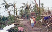 Currently the tendency to over exploit coastal resources is placing increasing stress on viability of the ecosystem. The growing population pressure and the related socio-economic consequences put extensive pressure on the development of land use patterns and infrastructure management for exploitation of water resources, thus risking the quality of life of our future generation. Around 80 per cent of the total poor live in rural areas. The larger part of their income, about 30 per cent of GDP and 60 per cent of rural employment come from this sector. The poverty rate is 53 per cent in the coastal area against 48 per cent in whole of the nation
Cyclone toll 'may never be known'
Bodies continue to surface in paddy fields and along river banks, as volunteers and seconded municipal workers carry on the grim task of disposing of those retrieved earlier. Tidal waves submerge coastal areas
80,000 forced to leave flooded homes, 500 fishermen missing, September 21, 2005
Water entered the island easily through the breaches in the embankment after the tidal wave, said Rabbani, adding that the affected people were forced to take shelter in the cyclone centres.
Tidal waves that were 3-4 feet higher than normal also inundated some places at Anwara and Banshkhali coastal areas, causing considerable suffering to the local people (New Age September 21, 2005).1. Poor farmers losing lands to shrimp farm owners
2. Destruction of sustainable ecosystem for the finest kitchen of the Industrial Countries
3. Some Sobering Statistics On World's Poor
4. Will someone listen to the poor farmers’ tearful appeal?
Development Program
History of Bengal
HELP
Top of page
Home